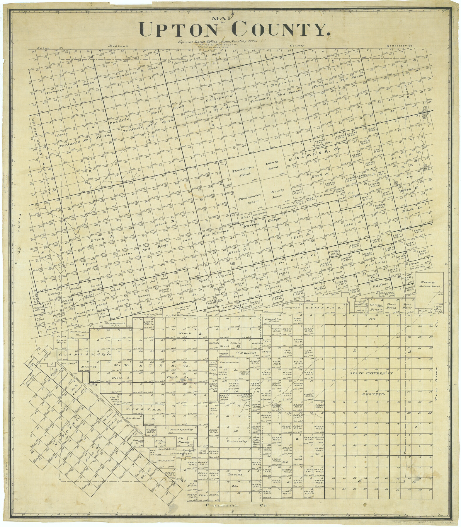
Map of Upton County
-
Map/Doc
63087
-
Collection
General Map Collection
-
Object Dates
1899 (Creation Date)
-
People and Organizations
Texas General Land Office (Publisher)
Sam Bonham (Compiler)
-
Counties
Upton
-
Subjects
County
-
Height x Width
46.0 x 40.2 inches
116.8 x 102.1 cm
-
Comments
Copied in June 1900.
Part of: General Map Collection
Flight Mission No. DIX-10P, Frame 178, Aransas County

Print $20.00
- Digital $50.00
Flight Mission No. DIX-10P, Frame 178, Aransas County
1956
Size 18.5 x 22.2 inches
Map/Doc 83968
Collingsworth County Working Sketch 4

Print $20.00
- Digital $50.00
Collingsworth County Working Sketch 4
1960
Size 42.6 x 17.3 inches
Map/Doc 68092
Collin County Sketch File 3

Print $20.00
- Digital $50.00
Collin County Sketch File 3
1852
Size 19.5 x 21.4 inches
Map/Doc 11126
Harris County Working Sketch 7

Print $20.00
- Digital $50.00
Harris County Working Sketch 7
1900
Size 34.2 x 28.6 inches
Map/Doc 65899
Montague County Sketch File 10

Print $4.00
- Digital $50.00
Montague County Sketch File 10
1873
Size 7.9 x 11.8 inches
Map/Doc 31732
[T. & G. Ry. Main Line, Texas, Right of Way Map, Center to Gary]
![64571, [T. & G. Ry. Main Line, Texas, Right of Way Map, Center to Gary], General Map Collection](https://historictexasmaps.com/wmedia_w700/maps/64571-1.tif.jpg)
Print $40.00
- Digital $50.00
[T. & G. Ry. Main Line, Texas, Right of Way Map, Center to Gary]
1917
Size 31.9 x 121.1 inches
Map/Doc 64571
Right-of-Way and Track Map, Texas State Railroad operated by the T. and N.O. R.R. Co.

Print $40.00
- Digital $50.00
Right-of-Way and Track Map, Texas State Railroad operated by the T. and N.O. R.R. Co.
1917
Size 25.2 x 56.1 inches
Map/Doc 64171
Glasscock County Rolled Sketch 2

Print $20.00
- Digital $50.00
Glasscock County Rolled Sketch 2
1906
Size 19.6 x 14.8 inches
Map/Doc 6013
Van Zandt County Sketch File 12

Print $6.00
- Digital $50.00
Van Zandt County Sketch File 12
1858
Size 10.2 x 8.0 inches
Map/Doc 39399

Uvalde County Sketch File 33

Print $56.00
- Digital $50.00
Uvalde County Sketch File 33
2017
Size 11.0 x 8.5 inches
Map/Doc 95251
Limestone County Sketch File 11

Print $4.00
- Digital $50.00
Limestone County Sketch File 11
1881
Size 7.9 x 9.5 inches
Map/Doc 30177
You may also like
Irrigation in West Texas - the Pecos and Toyah Valleys

Irrigation in West Texas - the Pecos and Toyah Valleys
1912
Size 9.3 x 4.5 inches
Map/Doc 97072
Gregg County Working Sketch 3

Print $20.00
- Digital $50.00
Gregg County Working Sketch 3
1931
Size 18.6 x 14.2 inches
Map/Doc 63269
Palo Pinto County Working Sketch 7

Print $20.00
- Digital $50.00
Palo Pinto County Working Sketch 7
1922
Map/Doc 71390
Map of Galveston Bay from Lawrence Cove to Stevenson's Station

Print $20.00
- Digital $50.00
Map of Galveston Bay from Lawrence Cove to Stevenson's Station
1851
Size 35.2 x 29.7 inches
Map/Doc 69921
Montague County Working Sketch 17

Print $20.00
- Digital $50.00
Montague County Working Sketch 17
1947
Size 22.1 x 30.0 inches
Map/Doc 71083
Hudspeth County Rolled Sketch 53

Print $77.00
- Digital $50.00
Hudspeth County Rolled Sketch 53
1977
Size 9.9 x 15.1 inches
Map/Doc 45849
[Texas Boundary Line]
![92069, [Texas Boundary Line], Twichell Survey Records](https://historictexasmaps.com/wmedia_w700/maps/92069-1.tif.jpg)
Print $20.00
- Digital $50.00
[Texas Boundary Line]
Size 31.8 x 18.1 inches
Map/Doc 92069
San Patricio County NRC Article 33.136 Location Key Sheet

Print $20.00
- Digital $50.00
San Patricio County NRC Article 33.136 Location Key Sheet
1975
Size 27.0 x 23.0 inches
Map/Doc 77036
Dawson County Sketch File 19

Print $20.00
- Digital $50.00
Dawson County Sketch File 19
1951
Size 18.5 x 24.7 inches
Map/Doc 11295
Hutchinson County Rolled Sketch 44-10

Print $20.00
- Digital $50.00
Hutchinson County Rolled Sketch 44-10
2002
Size 24.0 x 36.0 inches
Map/Doc 77546
Newton County Working Sketch 37

Print $20.00
- Digital $50.00
Newton County Working Sketch 37
1960
Size 31.7 x 22.7 inches
Map/Doc 71283
Presidio County Sketch File K

Print $8.00
- Digital $50.00
Presidio County Sketch File K
1907
Size 13.6 x 8.6 inches
Map/Doc 34456