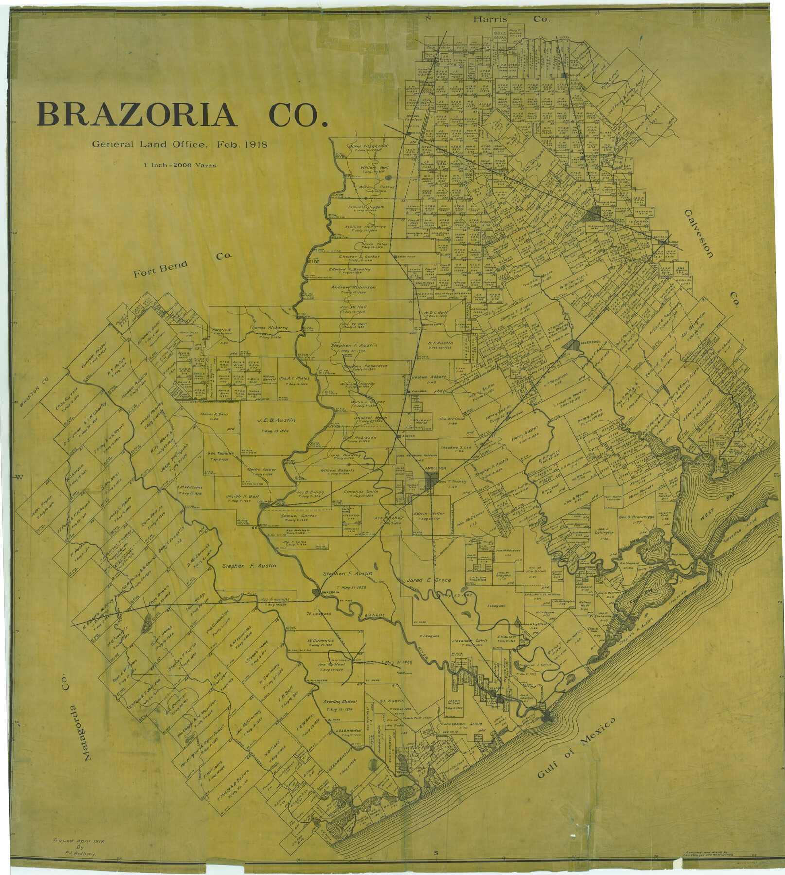
Brazoria Co.
-
Map/Doc
82067
-
Collection
General Map Collection
-
Object Dates
1918 (Creation Date)
-
People and Organizations
Texas General Land Office (Publisher)
Leo Ehlinger (Compiler)
Leo Ehlinger (Draftsman)
H.F. McDonald (Compiler)
H.F. McDonald (Draftsman)
-
Counties
Brazoria
-
Subjects
County
-
Height x Width
56.2 x 50.4 inches
142.7 x 128.0 cm
-
Comments
Traced by P. J. Anthony in 1918.
Part of: General Map Collection
Harris County Historic Topographic 29

Print $20.00
- Digital $50.00
Harris County Historic Topographic 29
1915
Size 29.1 x 23.0 inches
Map/Doc 65840

[Map of the Houston and Great Northern R. R. from Trinity River to Palestine]
![64550, [Map of the Houston and Great Northern R. R. from Trinity River to Palestine], General Map Collection](https://historictexasmaps.com/wmedia_w700/maps/64550.tif.jpg)
Print $40.00
- Digital $50.00
[Map of the Houston and Great Northern R. R. from Trinity River to Palestine]
1872
Size 30.0 x 88.0 inches
Map/Doc 64550
Galveston County Rolled Sketch Z62

Print $20.00
- Digital $50.00
Galveston County Rolled Sketch Z62
1933
Size 34.7 x 22.7 inches
Map/Doc 5994
Morris County Rolled Sketch 2A

Print $20.00
- Digital $50.00
Morris County Rolled Sketch 2A
Size 36.7 x 25.1 inches
Map/Doc 10259
La Salle County Working Sketch 44

Print $40.00
- Digital $50.00
La Salle County Working Sketch 44
1980
Size 34.7 x 65.8 inches
Map/Doc 70345
Aransas County Sketch File 36

Print $288.00
- Digital $50.00
Aransas County Sketch File 36
Size 8.5 x 10.9 inches
Map/Doc 13360
[Sketch for Mineral Application 1112 - Colorado River, H. E. Chambers]
![65635, [Sketch for Mineral Application 1112 - Colorado River, H. E. Chambers], General Map Collection](https://historictexasmaps.com/wmedia_w700/maps/65635.tif.jpg)
Print $40.00
- Digital $50.00
[Sketch for Mineral Application 1112 - Colorado River, H. E. Chambers]
1918
Size 25.8 x 48.1 inches
Map/Doc 65635
Crane County Sketch File 15 (C-1)

Print $6.00
- Digital $50.00
Crane County Sketch File 15 (C-1)
1925
Size 8.8 x 15.4 inches
Map/Doc 19579
Duval County Sketch File 26

Print $4.00
- Digital $50.00
Duval County Sketch File 26
1882
Size 13.0 x 9.0 inches
Map/Doc 21332
Flight Mission No. DAG-17K, Frame 74, Matagorda County

Print $20.00
- Digital $50.00
Flight Mission No. DAG-17K, Frame 74, Matagorda County
1952
Size 18.5 x 22.3 inches
Map/Doc 86333
Leon County Rolled Sketch 12

Print $20.00
- Digital $50.00
Leon County Rolled Sketch 12
1974
Size 46.5 x 40.7 inches
Map/Doc 9431
You may also like
Jefferson County Rolled Sketch 60

Print $20.00
- Digital $50.00
Jefferson County Rolled Sketch 60
1885
Size 34.0 x 35.9 inches
Map/Doc 9316
Webb County Sketch File 3a

Print $40.00
- Digital $50.00
Webb County Sketch File 3a
1855
Size 32.1 x 20.8 inches
Map/Doc 12613
Maverick County Working Sketch 20

Print $20.00
- Digital $50.00
Maverick County Working Sketch 20
1977
Size 26.1 x 22.0 inches
Map/Doc 70912

Controlled Mosaic by Jack Amman Photogrammetric Engineers, Inc - Sheet 26

Print $20.00
- Digital $50.00
Controlled Mosaic by Jack Amman Photogrammetric Engineers, Inc - Sheet 26
1954
Size 20.0 x 24.0 inches
Map/Doc 83477
[Surveys South of Levi Pruitt and Jno. Welch]
![92091, [Surveys South of Levi Pruitt and Jno. Welch], Twichell Survey Records](https://historictexasmaps.com/wmedia_w700/maps/92091-1.tif.jpg)
Print $20.00
- Digital $50.00
[Surveys South of Levi Pruitt and Jno. Welch]
Size 18.2 x 6.3 inches
Map/Doc 92091
Red River County Working Sketch 11

Print $20.00
- Digital $50.00
Red River County Working Sketch 11
1935
Size 19.4 x 24.6 inches
Map/Doc 71994
Map of the Houston & Great Northern Railroad

Print $40.00
- Digital $50.00
Map of the Houston & Great Northern Railroad
1871
Size 26.6 x 48.4 inches
Map/Doc 64472
Political Essay on the Kingdom of New Spain Vol. 4

Political Essay on the Kingdom of New Spain Vol. 4
1822
Map/Doc 97389

Val Verde County Rolled Sketch 70

Print $20.00
- Digital $50.00
Val Verde County Rolled Sketch 70
1958
Size 23.2 x 18.8 inches
Map/Doc 8132
The Chief Justice County of Harrisburg. Lands in Conflict with Brazoria, Liberty Counties

Print $20.00
The Chief Justice County of Harrisburg. Lands in Conflict with Brazoria, Liberty Counties
2020
Size 17.5 x 21.7 inches
Map/Doc 96050