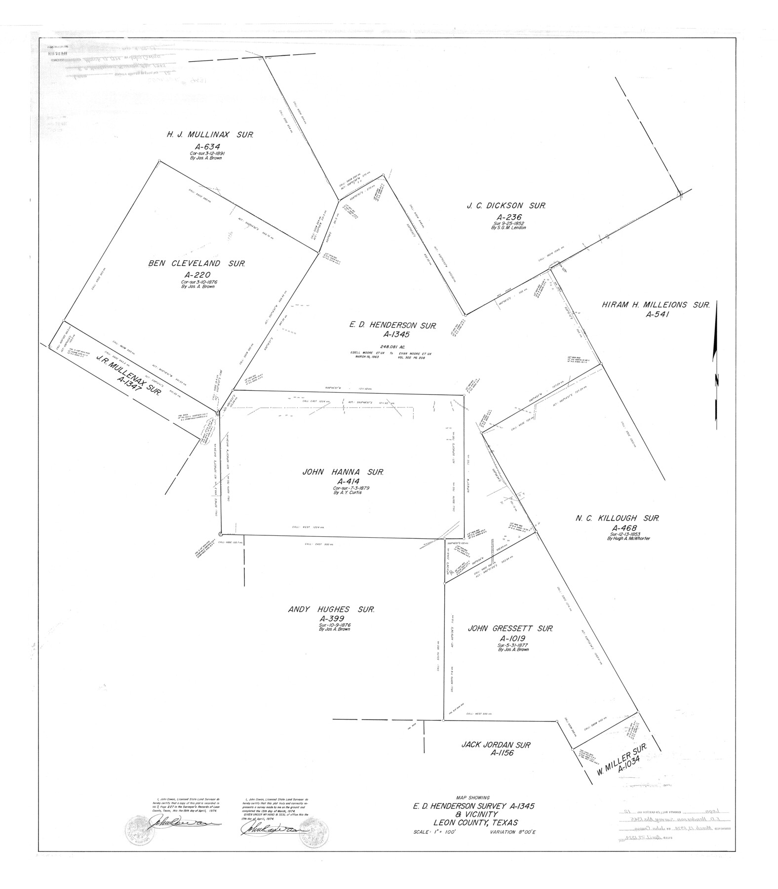
Leon County Rolled Sketch 12
Map showing E.D. Henderson survey A-1345 & vicinity, Leon County, Texas
-
Map/Doc
9431
-
Collection
General Map Collection
-
Object Dates
1974/3/13 (Survey Date)
1974/4/29 (File Date)
1974/4/17 (Creation Date)
-
People and Organizations
John Cowan (Surveyor/Engineer)
-
Counties
Leon
-
Subjects
Surveying Rolled Sketch
-
Height x Width
46.5 x 40.7 inches
118.1 x 103.4 cm
-
Scale
1" = 100 feet
Part of: General Map Collection
Travis County Rolled Sketch 56

Print $20.00
- Digital $50.00
Travis County Rolled Sketch 56
1885
Size 16.7 x 23.2 inches
Map/Doc 8047
Runnels County Sketch File 34

Print $20.00
Runnels County Sketch File 34
1889
Size 16.6 x 26.7 inches
Map/Doc 12265
Map of Bandera County
Print $20.00
- Digital $50.00
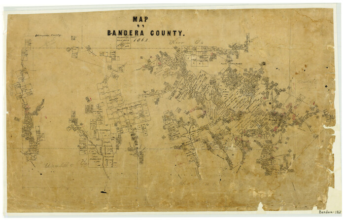
Map of Bandera County
1862
Size 19.0 x 30.1 inches
Map/Doc 3271
Current Miscellaneous File 49

Print $4.00
- Digital $50.00
Current Miscellaneous File 49
Size 11.2 x 8.8 inches
Map/Doc 74012
Val Verde County Sketch File 51c

Print $6.00
- Digital $50.00
Val Verde County Sketch File 51c
1959
Size 10.9 x 16.9 inches
Map/Doc 39332
Mason County Boundary File 5

Print $20.00
- Digital $50.00
Mason County Boundary File 5
Size 9.7 x 7.0 inches
Map/Doc 56862
Howard County Working Sketch 11

Print $20.00
- Digital $50.00
Howard County Working Sketch 11
1962
Size 20.5 x 20.3 inches
Map/Doc 66279
Matagorda Light to Aransas Pass

Print $20.00
- Digital $50.00
Matagorda Light to Aransas Pass
1974
Size 36.5 x 45.3 inches
Map/Doc 73401
Reeves County Sketch File 19

Print $9.00
- Digital $50.00
Reeves County Sketch File 19
1958
Size 11.3 x 8.9 inches
Map/Doc 35212
Stonewall County Rolled Sketch 28

Print $20.00
- Digital $50.00
Stonewall County Rolled Sketch 28
Size 42.8 x 46.5 inches
Map/Doc 9967
Parker County State Real Property Sketch 1

Print $20.00
- Digital $50.00
Parker County State Real Property Sketch 1
2022
Size 47.4 x 35.1 inches
Map/Doc 96678
Leon County Rolled Sketch 7

Print $40.00
- Digital $50.00
Leon County Rolled Sketch 7
1954
Size 55.9 x 35.0 inches
Map/Doc 9428
You may also like
Flight Mission No. CRK-7P, Frame 133, Refugio County

Print $20.00
- Digital $50.00
Flight Mission No. CRK-7P, Frame 133, Refugio County
1956
Size 18.3 x 22.1 inches
Map/Doc 86956
Map Showing Colonel A.W. Doniphan's Route through the States of New Mexico, Chihuahua and Coahuila

Print $20.00
Map Showing Colonel A.W. Doniphan's Route through the States of New Mexico, Chihuahua and Coahuila
1847
Size 16.9 x 14.0 inches
Map/Doc 79729
Harris County Rolled Sketch 89

Print $20.00
- Digital $50.00
Harris County Rolled Sketch 89
1899
Size 22.1 x 35.3 inches
Map/Doc 6128

Flight Mission No. CLL-1N, Frame 76, Willacy County

Print $20.00
- Digital $50.00
Flight Mission No. CLL-1N, Frame 76, Willacy County
1954
Size 18.3 x 22.0 inches
Map/Doc 87022
Presidio County Working Sketch 109

Print $20.00
- Digital $50.00
Presidio County Working Sketch 109
1980
Size 23.3 x 21.4 inches
Map/Doc 71786
Rains County Boundary File 71

Print $6.00
- Digital $50.00
Rains County Boundary File 71
Size 8.7 x 3.5 inches
Map/Doc 58094
Green & Lumsden's Ranch

Print $20.00
- Digital $50.00
Green & Lumsden's Ranch
Size 28.9 x 25.1 inches
Map/Doc 92946
Coleman County Working Sketch 9

Print $20.00
- Digital $50.00
Coleman County Working Sketch 9
1950
Size 24.9 x 30.5 inches
Map/Doc 68075
Stonewall County Sketch File 19

Print $20.00
- Digital $50.00
Stonewall County Sketch File 19
Size 33.2 x 33.6 inches
Map/Doc 10392
Hardin County

Print $20.00
- Digital $50.00
Hardin County
1894
Size 46.8 x 43.4 inches
Map/Doc 16846
Culberson County Sketch File 10

Print $4.00
- Digital $50.00
Culberson County Sketch File 10
1911
Size 14.6 x 9.0 inches
Map/Doc 20144