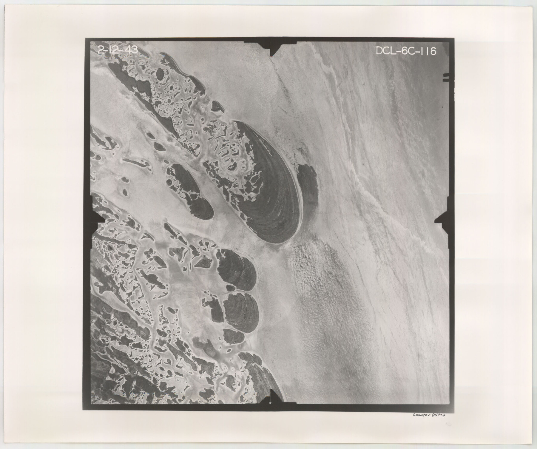
Flight Mission No. DCL-6C, Frame 116, Kenedy County
DCL-6C-116
-
Map/Doc
85946
-
Collection
General Map Collection
-
Object Dates
1943/2/12 (Creation Date)
-
People and Organizations
U. S. Department of Agriculture (Publisher)
-
Counties
Kenedy
-
Subjects
Aerial Photograph
-
Height x Width
18.6 x 22.2 inches
47.2 x 56.4 cm
-
Comments
Flown by Aerial Surveys of Pittsburgh, Inc. of Pittsburgh, Pennsylvania.
Part of: General Map Collection
Briscoe County Sketch File 3

Print $40.00
- Digital $50.00
Briscoe County Sketch File 3
1885
Size 22.6 x 20.7 inches
Map/Doc 10992
Brewster County Sketch File 23

Print $12.00
- Digital $50.00
Brewster County Sketch File 23
1958
Size 11.3 x 8.7 inches
Map/Doc 15825
Flight Mission No. DIX-5P, Frame 150, Aransas County

Print $20.00
- Digital $50.00
Flight Mission No. DIX-5P, Frame 150, Aransas County
1956
Size 17.8 x 18.3 inches
Map/Doc 83812
Map of Lamar County

Print $20.00
- Digital $50.00
Map of Lamar County
1849
Size 25.7 x 26.8 inches
Map/Doc 1236
Cottle County Working Sketch 5

Print $20.00
- Digital $50.00
Cottle County Working Sketch 5
1921
Size 13.5 x 25.5 inches
Map/Doc 68315
Map of Cherokee County

Print $20.00
- Digital $50.00
Map of Cherokee County
1863
Size 25.5 x 17.7 inches
Map/Doc 3387
Angelina County Working Sketch 38

Print $20.00
- Digital $50.00
Angelina County Working Sketch 38
1958
Size 26.4 x 33.0 inches
Map/Doc 67121
G. C. & S. F. Ry. Northern-Division, Alignment and Right of Way Map, Weatherford Branch, Johnson and Hood Counties, Texas

Print $40.00
- Digital $50.00
G. C. & S. F. Ry. Northern-Division, Alignment and Right of Way Map, Weatherford Branch, Johnson and Hood Counties, Texas
1935
Size 37.8 x 100.5 inches
Map/Doc 64649
Starr County Rolled Sketch 31

Print $20.00
- Digital $50.00
Starr County Rolled Sketch 31
1941
Size 22.5 x 32.6 inches
Map/Doc 7828
Mason County Sketch File 3a

Print $4.00
- Digital $50.00
Mason County Sketch File 3a
1877
Size 8.3 x 7.9 inches
Map/Doc 30682
Comanche County Working Sketch 26

Print $20.00
- Digital $50.00
Comanche County Working Sketch 26
1981
Size 26.0 x 32.4 inches
Map/Doc 68160
Lampasas County Boundary File 9

Print $6.00
- Digital $50.00
Lampasas County Boundary File 9
Size 11.2 x 8.7 inches
Map/Doc 56181
You may also like
Reagan County Sketch File 14

Print $6.00
- Digital $50.00
Reagan County Sketch File 14
Size 11.3 x 8.8 inches
Map/Doc 34993
Chambers County Rolled Sketch 23B

Print $20.00
- Digital $50.00
Chambers County Rolled Sketch 23B
1940
Size 40.9 x 40.8 inches
Map/Doc 8593
Cass County Working Sketch 13

Print $20.00
- Digital $50.00
Cass County Working Sketch 13
1945
Size 29.8 x 33.5 inches
Map/Doc 67916
Chambers County Working Sketch 11

Print $20.00
- Digital $50.00
Chambers County Working Sketch 11
1952
Size 40.6 x 26.7 inches
Map/Doc 67994
Part of the boundary between the United States and Texas; from Sabine River northward to the 36th mile mound

Print $2.00
- Digital $50.00
Part of the boundary between the United States and Texas; from Sabine River northward to the 36th mile mound
1842
Size 12.5 x 7.6 inches
Map/Doc 93769
[Sketch for Mineral Application 19560 - 19588 - San Bernard River]
![65660, [Sketch for Mineral Application 19560 - 19588 - San Bernard River], General Map Collection](https://historictexasmaps.com/wmedia_w700/maps/65660.tif.jpg)
Print $40.00
- Digital $50.00
[Sketch for Mineral Application 19560 - 19588 - San Bernard River]
Size 98.0 x 33.0 inches
Map/Doc 65660

Swisher County Sketch File 10

Print $6.00
- Digital $50.00
Swisher County Sketch File 10
1936
Size 11.0 x 15.9 inches
Map/Doc 37631
Fort Bend County Sketch File 36

Print $6.00
- Digital $50.00
Fort Bend County Sketch File 36
1997
Size 11.4 x 8.9 inches
Map/Doc 23007
Map of survey 189, T. C. R.R. Co. in Travis County, Texas

Print $20.00
- Digital $50.00
Map of survey 189, T. C. R.R. Co. in Travis County, Texas
1915
Size 18.6 x 15.2 inches
Map/Doc 78479
Bowie County Working Sketch 22

Print $40.00
- Digital $50.00
Bowie County Working Sketch 22
1968
Size 49.0 x 37.8 inches
Map/Doc 67426
Trinity County Working Sketch 7b

Print $20.00
- Digital $50.00
Trinity County Working Sketch 7b
1939
Size 27.4 x 24.7 inches
Map/Doc 69456