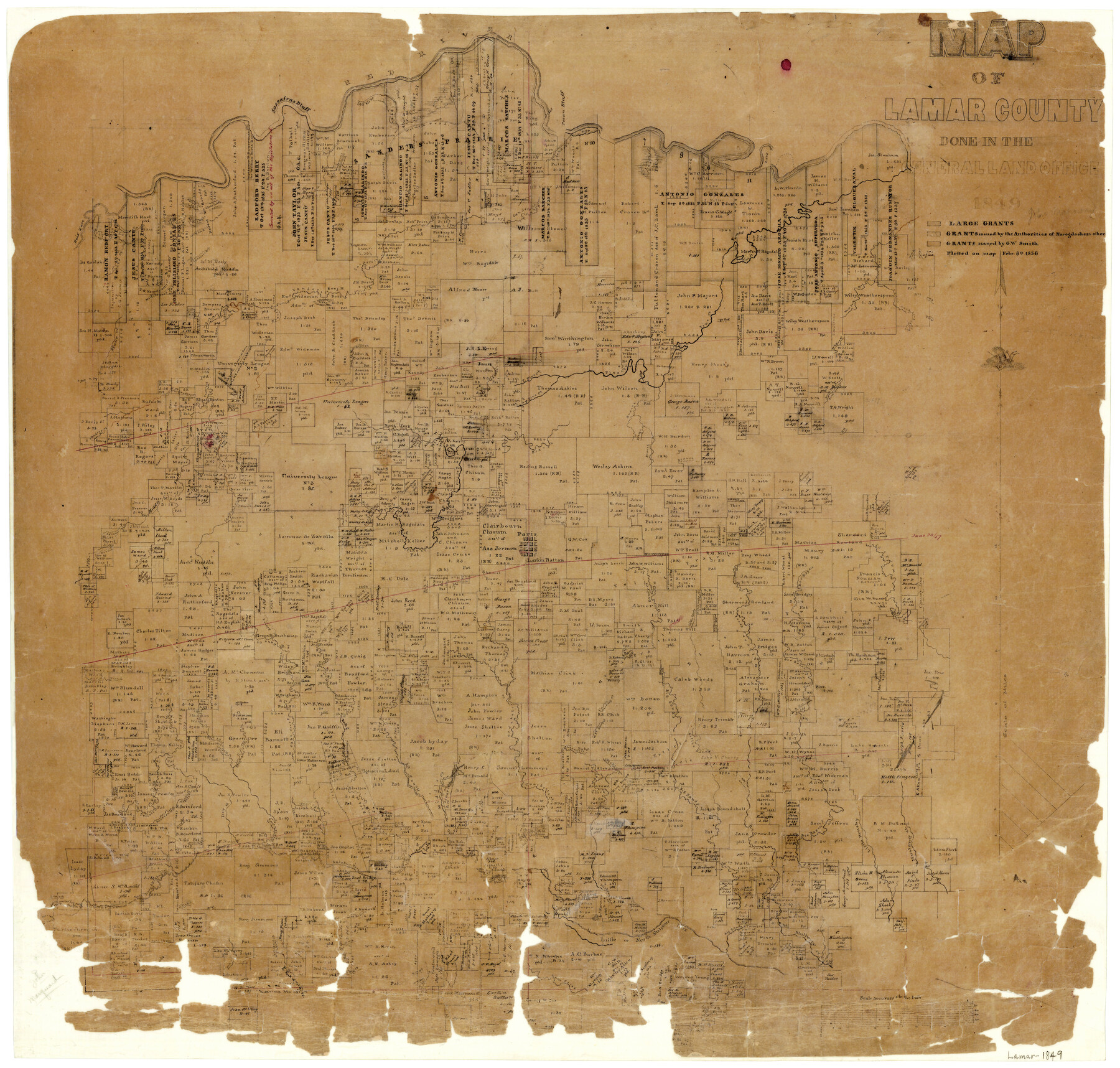
Map of Lamar County
-
Map/Doc
1236
-
Collection
General Map Collection
-
Object Dates
1849 (Creation Date)
-
People and Organizations
Texas General Land Office (Publisher)
-
Counties
Lamar
-
Subjects
County
-
Height x Width
25.7 x 26.8 inches
65.3 x 68.1 cm
-
Features
Big Sandy Creek
Middle Creek
Alexander's Creek
Click's Creek
Brushy Creek
Cherrys Creek
Bee Bayou
Little Brushy Creek
Mustang Creek
Honey Creek
West Fork of Sandy Creek
Hickory Creek
Rock Creek
Crocket's [sic] Creek
Sulphur Fork
Cane Creek
Sandy Creek
Little Sandy Creek
North Sulphur River
North Fork of Sulphur River
Dry Creek
Brigham's Creek
Nobels Creek
Sandsoury Creek
Tollets Creek
North Prong of Sulphur Fork
Lake Creek
Little Sulphur Fork
North Sulphur Fork
Words Creek
Little Fork
Richland Creek
East Fork of Big Creek
West Fork of Pine Creek
Martin's Road
Spencer's Branch
Clear Lake
Muddy Lake
Road [South of Muddy Lake]
East Fork of Pine Creek
Pine Creek
South Fork of Lower Pine Creek
Slew Creek
Sander's Creek
Pecan Bluff
Welmoth Road
Wideman's Road
Slew Lake
Old [Red] River
Red River
Sassafras Bluff
Red Gut Lake
Horseshoe Lake
Bois d'Arc [Creek]
Sluice Creek
Warton's Creek
South Fork of Pine Creek
Lower Pine Creek
Crocketts Creek
West Fork of Sanders Creek
North Fork of Sander's Creek
Middle Fork [of Sander's Creek]
Ward's Creek
North Fork of Pine Creek
Mulberry Creek
Paris
Part of: General Map Collection
Starr County Sketch File 42

Print $20.00
- Digital $50.00
Starr County Sketch File 42
1941
Size 19.0 x 21.6 inches
Map/Doc 12341
Kinney County Working Sketch 28

Print $20.00
- Digital $50.00
Kinney County Working Sketch 28
1957
Size 33.3 x 34.4 inches
Map/Doc 70210
Van Zandt County Boundary File 90

Print $10.00
- Digital $50.00
Van Zandt County Boundary File 90
Size 9.5 x 4.0 inches
Map/Doc 59650
Cherokee County Sketch File 5

Print $12.00
- Digital $50.00
Cherokee County Sketch File 5
1852
Size 12.4 x 8.6 inches
Map/Doc 18120
Lloyd's Map of the Southern States showing all the Railroads, their Stations & Distances, also the Counties, Towns, Villages, Harbors, Rivers, and Forts

Print $40.00
- Digital $50.00
Lloyd's Map of the Southern States showing all the Railroads, their Stations & Distances, also the Counties, Towns, Villages, Harbors, Rivers, and Forts
1861
Size 39.3 x 54.4 inches
Map/Doc 96556
[Surveys in Austin's Colony along the Colorado River]
![171, [Surveys in Austin's Colony along the Colorado River], General Map Collection](https://historictexasmaps.com/wmedia_w700/maps/171.tif.jpg)
Print $20.00
- Digital $50.00
[Surveys in Austin's Colony along the Colorado River]
1830
Size 30.5 x 12.7 inches
Map/Doc 171
Duval County Working Sketch 12

Print $20.00
- Digital $50.00
Duval County Working Sketch 12
1937
Size 22.1 x 27.8 inches
Map/Doc 68725
Sutton County Sketch File 55

Print $24.00
- Digital $50.00
Sutton County Sketch File 55
1952
Size 11.3 x 8.8 inches
Map/Doc 37536
Sabine County Working Sketch 14

Print $20.00
- Digital $50.00
Sabine County Working Sketch 14
1953
Size 29.3 x 38.6 inches
Map/Doc 63685
Palo Pinto County Working Sketch 15

Print $20.00
- Digital $50.00
Palo Pinto County Working Sketch 15
1971
Size 26.4 x 30.8 inches
Map/Doc 71398
Sutton County Sketch File JT

Print $12.00
- Digital $50.00
Sutton County Sketch File JT
Size 14.4 x 8.6 inches
Map/Doc 37453
[Sketch for Mineral Application 12206 - Cow Bayou, O. B. Sawyer]
![65570, [Sketch for Mineral Application 12206 - Cow Bayou, O. B. Sawyer], General Map Collection](https://historictexasmaps.com/wmedia_w700/maps/65570.tif.jpg)
Print $40.00
- Digital $50.00
[Sketch for Mineral Application 12206 - Cow Bayou, O. B. Sawyer]
Size 37.0 x 63.3 inches
Map/Doc 65570
You may also like
General Highway Map, Williamson County, Texas

Print $20.00
General Highway Map, Williamson County, Texas
1961
Size 24.8 x 18.2 inches
Map/Doc 79713
Orange County Rolled Sketch 18

Print $20.00
- Digital $50.00
Orange County Rolled Sketch 18
Size 11.6 x 12.6 inches
Map/Doc 7182
Nueces River, Corpus Christi Sheet No. 6

Print $6.00
- Digital $50.00
Nueces River, Corpus Christi Sheet No. 6
1938
Size 31.3 x 31.0 inches
Map/Doc 65095
West Part of Liberty Co.

Print $40.00
- Digital $50.00
West Part of Liberty Co.
1977
Size 48.0 x 36.9 inches
Map/Doc 95570
Houston County Sketch File 3

Print $6.00
- Digital $50.00
Houston County Sketch File 3
Size 13.1 x 8.2 inches
Map/Doc 26748
Webb County Sketch File 25

Print $20.00
- Digital $50.00
Webb County Sketch File 25
1936
Size 18.2 x 30.7 inches
Map/Doc 12639
Sabine River, Merrill Lake Sheet

Print $20.00
- Digital $50.00
Sabine River, Merrill Lake Sheet
1933
Size 26.4 x 43.6 inches
Map/Doc 65137
O'Neall Terrace Annex, a Re-Subdivision of the South One-half of Blocks 25 and 31 and all of Blocks 30, 32, and 33 of McCrummen's Second Addition, Lubbock, Texas

Print $20.00
- Digital $50.00
O'Neall Terrace Annex, a Re-Subdivision of the South One-half of Blocks 25 and 31 and all of Blocks 30, 32, and 33 of McCrummen's Second Addition, Lubbock, Texas
1928
Size 23.2 x 27.6 inches
Map/Doc 92747
Angelina County

Print $40.00
- Digital $50.00
Angelina County
1945
Size 39.0 x 48.4 inches
Map/Doc 73068
Fayette County Boundary File 2a

Print $8.00
- Digital $50.00
Fayette County Boundary File 2a
Size 14.9 x 9.3 inches
Map/Doc 53345
Castro County Sketch File 4b

Print $4.00
- Digital $50.00
Castro County Sketch File 4b
Size 13.5 x 8.9 inches
Map/Doc 17467
[Resurvey of Block 1 - W. H. Godair]
![92898, [Resurvey of Block 1 - W. H. Godair], Twichell Survey Records](https://historictexasmaps.com/wmedia_w700/maps/92898-1.tif.jpg)
Print $20.00
- Digital $50.00
[Resurvey of Block 1 - W. H. Godair]
1923
Size 22.4 x 9.5 inches
Map/Doc 92898