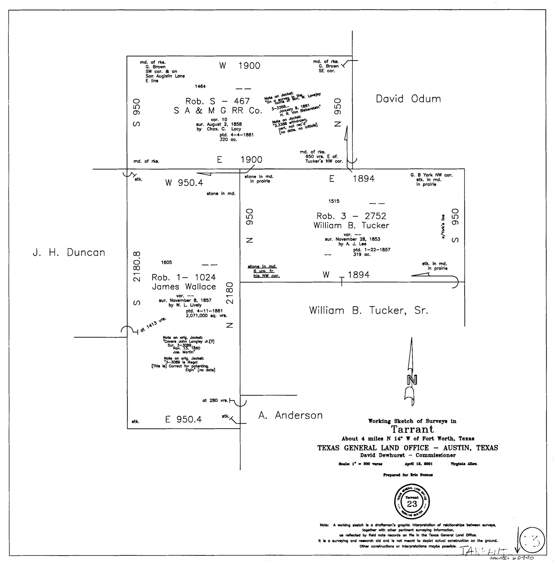
Tarrant County Working Sketch 23
-
Map/Doc
62440
-
Collection
General Map Collection
-
Object Dates
4/12/2001 (Creation Date)
-
People and Organizations
Virginia Allen (Draftsman)
-
Counties
Tarrant
-
Subjects
Surveying Working Sketch
-
Height x Width
15.9 x 15.6 inches
40.4 x 39.6 cm
-
Scale
1" = 300 varas
Part of: General Map Collection
Galveston County NRC Article 33.136 Sketch 32

Print $26.00
- Digital $50.00
Galveston County NRC Article 33.136 Sketch 32
2005
Size 24.5 x 36.8 inches
Map/Doc 83173
Map of Anderson County

Print $20.00
- Digital $50.00
Map of Anderson County
1855
Size 23.7 x 28.9 inches
Map/Doc 3225
1988 Land Use - El Paso, Ciudad Juarez and Vicinity

Print $20.00
- Digital $50.00
1988 Land Use - El Paso, Ciudad Juarez and Vicinity
1988
Size 34.2 x 25.1 inches
Map/Doc 87369
Ellis County Sketch File 6

Print $24.00
- Digital $50.00
Ellis County Sketch File 6
Size 12.3 x 8.2 inches
Map/Doc 21836
Haskell County Working Sketch 15

Print $40.00
- Digital $50.00
Haskell County Working Sketch 15
1983
Size 48.0 x 57.5 inches
Map/Doc 66073
Lavaca County Working Sketch 9

Print $20.00
- Digital $50.00
Lavaca County Working Sketch 9
1949
Size 24.7 x 33.9 inches
Map/Doc 70362
Mason County Sketch File 21

Print $6.00
- Digital $50.00
Mason County Sketch File 21
Size 15.7 x 10.9 inches
Map/Doc 30717
Hutchinson County

Print $20.00
- Digital $50.00
Hutchinson County
Size 18.4 x 17.7 inches
Map/Doc 3695
Hood County Working Sketch 31

Print $20.00
- Digital $50.00
Hood County Working Sketch 31
1998
Size 33.6 x 35.8 inches
Map/Doc 66225
Flight Mission No. DCL-7C, Frame 16, Kenedy County

Print $20.00
- Digital $50.00
Flight Mission No. DCL-7C, Frame 16, Kenedy County
1943
Size 15.2 x 15.4 inches
Map/Doc 86008
Flight Mission No. CRC-2R, Frame 3, Chambers County

Print $20.00
- Digital $50.00
Flight Mission No. CRC-2R, Frame 3, Chambers County
1956
Size 18.8 x 22.5 inches
Map/Doc 84722
Cherokee County Boundary File 3

Print $34.00
- Digital $50.00
Cherokee County Boundary File 3
Size 11.2 x 8.8 inches
Map/Doc 51285
You may also like
Taylor County Sketch File 16

Print $20.00
- Digital $50.00
Taylor County Sketch File 16
1883
Size 34.3 x 9.0 inches
Map/Doc 12409
Map of surveys 191 & 192 T. C. R.R. Co. in Travis County, Texas

Print $20.00
- Digital $50.00
Map of surveys 191 & 192 T. C. R.R. Co. in Travis County, Texas
1915
Size 20.6 x 13.5 inches
Map/Doc 75556
Bell County Sketch File 27

Print $4.00
- Digital $50.00
Bell County Sketch File 27
1870
Size 8.9 x 9.4 inches
Map/Doc 14435
Gonzales County Sketch File 12

Print $4.00
- Digital $50.00
Gonzales County Sketch File 12
Size 10.8 x 8.7 inches
Map/Doc 24394
El Paso County Working Sketch 48

Print $20.00
- Digital $50.00
El Paso County Working Sketch 48
1987
Size 32.7 x 29.4 inches
Map/Doc 69070
[Map showing connecting line from New Mexico to Double Lakes]
![91997, [Map showing connecting line from New Mexico to Double Lakes], Twichell Survey Records](https://historictexasmaps.com/wmedia_w700/maps/91997-1.tif.jpg)
Print $20.00
- Digital $50.00
[Map showing connecting line from New Mexico to Double Lakes]
1913
Size 39.3 x 24.2 inches
Map/Doc 91997
[Working Sketch Survey 46]
![90955, [Working Sketch Survey 46], Twichell Survey Records](https://historictexasmaps.com/wmedia_w700/maps/90955-1.tif.jpg)
Print $20.00
- Digital $50.00
[Working Sketch Survey 46]
Size 19.0 x 11.8 inches
Map/Doc 90955
Trinity River, Rockwall Sheet/East Fork of Trinity River

Print $4.00
- Digital $50.00
Trinity River, Rockwall Sheet/East Fork of Trinity River
1936
Size 29.6 x 22.9 inches
Map/Doc 65193
Tom Green County Working Sketch 13

Print $20.00
- Digital $50.00
Tom Green County Working Sketch 13
1981
Size 34.3 x 26.4 inches
Map/Doc 69382
McMullen County

Print $40.00
- Digital $50.00
McMullen County
1918
Size 48.3 x 36.1 inches
Map/Doc 66923
Presidio County Sketch File 56

Print $4.00
- Digital $50.00
Presidio County Sketch File 56
1933
Size 11.3 x 8.8 inches
Map/Doc 34622
Nueces County Sketch File 69

Print $6.00
- Digital $50.00
Nueces County Sketch File 69
Size 11.1 x 8.7 inches
Map/Doc 33004