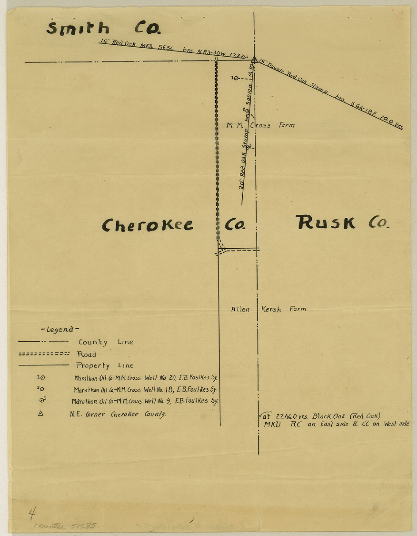
Cherokee County Boundary File 3
[Fieldnotes and sketch of a portion of the county line between Cherokee and Rusk Counties]
-
Map/Doc
51285
-
Collection
General Map Collection
-
Counties
Cherokee
-
Subjects
County Boundaries
-
Height x Width
11.2 x 8.8 inches
28.5 x 22.4 cm
Part of: General Map Collection
Ward County Working Sketch 25

Print $40.00
- Digital $50.00
Ward County Working Sketch 25
1957
Size 74.3 x 25.6 inches
Map/Doc 72331
Presidio County Working Sketch 98

Print $20.00
- Digital $50.00
Presidio County Working Sketch 98
1978
Size 30.9 x 31.7 inches
Map/Doc 71775
Blanco County Sketch File 17

Print $4.00
- Digital $50.00
Blanco County Sketch File 17
Size 12.2 x 7.9 inches
Map/Doc 14592
Maverick County Sketch File 4

Print $4.00
- Digital $50.00
Maverick County Sketch File 4
1876
Size 9.1 x 8.2 inches
Map/Doc 31051

Medina County Sketch File 16

Print $8.00
- Digital $50.00
Medina County Sketch File 16
1948
Size 11.4 x 8.8 inches
Map/Doc 31476
Gillespie County Sketch File 3a

Print $4.00
- Digital $50.00
Gillespie County Sketch File 3a
1860
Size 7.6 x 8.3 inches
Map/Doc 24131
Upton County Rolled Sketch JSP

Print $40.00
- Digital $50.00
Upton County Rolled Sketch JSP
1937
Size 39.2 x 68.0 inches
Map/Doc 10042
Maverick County Rolled Sketch 23

Print $91.00
- Digital $50.00
Maverick County Rolled Sketch 23
1965
Size 9.5 x 14.8 inches
Map/Doc 46786

Orange County Boundary File 9

Print $16.00
- Digital $50.00
Orange County Boundary File 9
Size 11.2 x 8.7 inches
Map/Doc 57782
Zavala County Working Sketch 6

Print $20.00
- Digital $50.00
Zavala County Working Sketch 6
1942
Size 30.8 x 26.5 inches
Map/Doc 62081
You may also like

[McLennan County School Land Leagues Nos. 3 and 4]
![90879, [McLennan County School Land Leagues Nos. 3 and 4], Twichell Survey Records](https://historictexasmaps.com/wmedia_w700/maps/90879-2.tif.jpg)
Print $20.00
- Digital $50.00
[McLennan County School Land Leagues Nos. 3 and 4]
1919
Size 9.1 x 18.6 inches
Map/Doc 90879
Cooke County Sketch File 4

Print $6.00
- Digital $50.00
Cooke County Sketch File 4
1856
Size 6.6 x 5.4 inches
Map/Doc 19223

Limestone County Working Sketch 16

Print $40.00
- Digital $50.00
Limestone County Working Sketch 16
1951
Size 55.7 x 27.8 inches
Map/Doc 70566
Montague County Sketch File 1

Print $40.00
- Digital $50.00
Montague County Sketch File 1
1852
Size 19.4 x 12.4 inches
Map/Doc 31709
West Part of Jeff Davis Co.

Print $20.00
- Digital $50.00
West Part of Jeff Davis Co.
1977
Size 35.0 x 45.2 inches
Map/Doc 73195
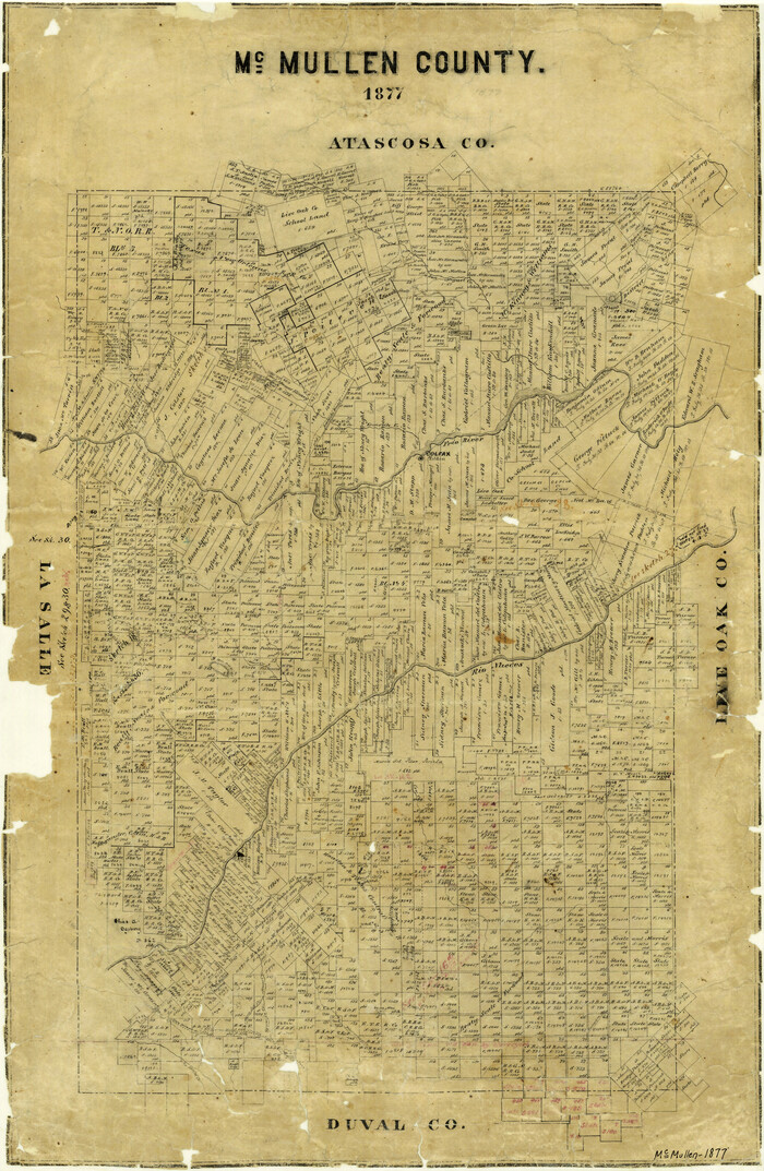
McMullen County
Print $20.00
- Digital $50.00
McMullen County
1877
Size 26.1 x 17.2 inches
Map/Doc 3867
Jackson County Rolled Sketch 7

Print $20.00
- Digital $50.00
Jackson County Rolled Sketch 7
1940
Size 23.0 x 32.2 inches
Map/Doc 6342
Starr County Sketch File 32B

Print $20.00
- Digital $50.00
Starr County Sketch File 32B
1938
Size 19.9 x 21.5 inches
Map/Doc 12336
Flight Mission No. CLL-1N, Frame 188, Willacy County

Print $20.00
- Digital $50.00
Flight Mission No. CLL-1N, Frame 188, Willacy County
1954
Size 18.4 x 22.0 inches
Map/Doc 87058
Crane County Sketch File 3a

Print $20.00
- Digital $50.00
Crane County Sketch File 3a
Size 20.8 x 13.0 inches
Map/Doc 11205