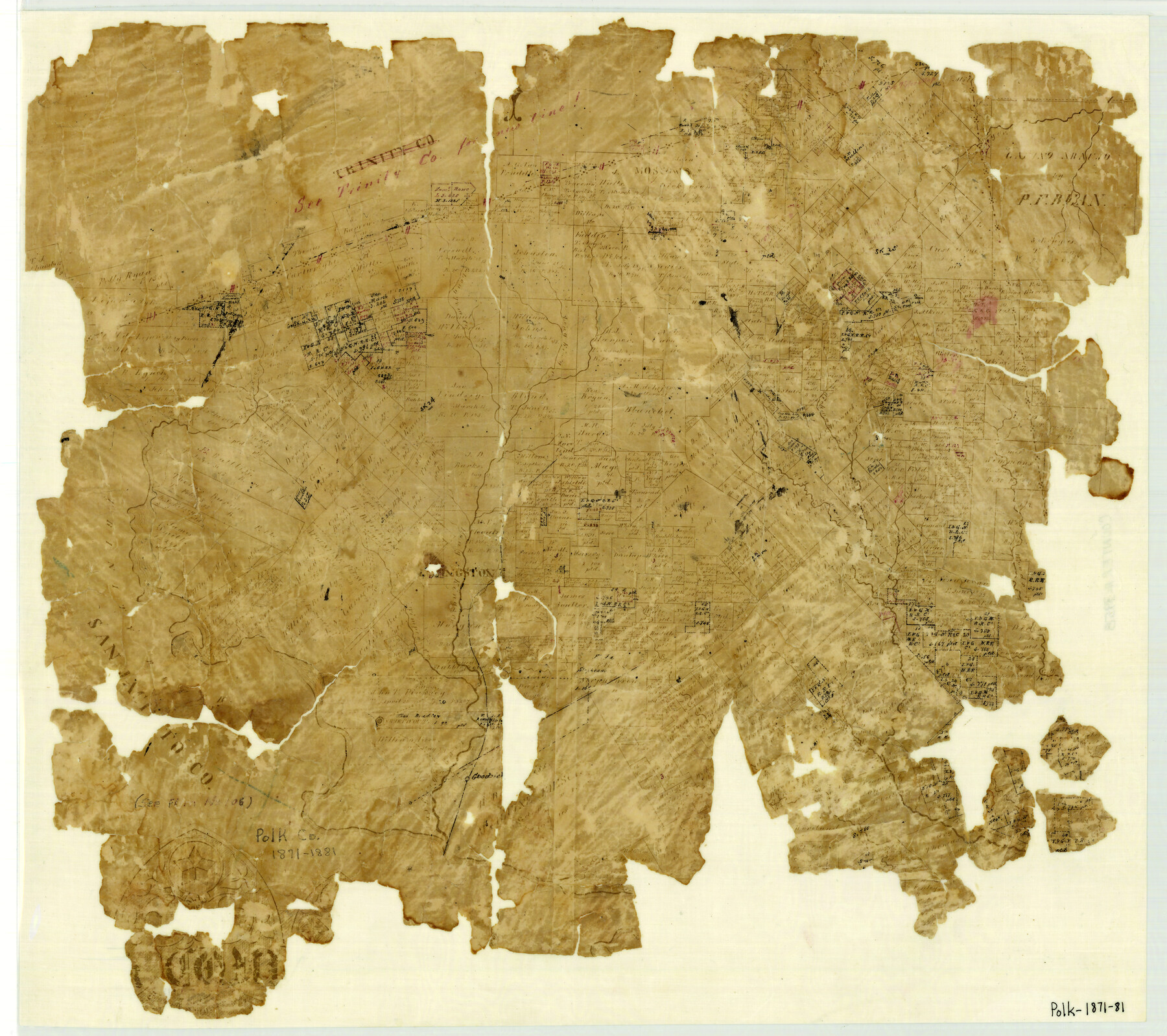
Polk County
-
Map/Doc
3958
-
Collection
General Map Collection
-
Object Dates
1871 (Creation Date)
-
People and Organizations
Texas General Land Office (Publisher)
Ed. Schutze (Compiler)
Ed. Schutze (Draftsman)
Herman Lungkwitz (Draftsman)
-
Counties
Polk
-
Subjects
County
-
Height x Width
17.4 x 19.6 inches
44.2 x 49.8 cm
-
Comments
Map covers from 1871 through 1881.
-
Features
Swartwout
West Prong of Double Bayou
East Prong of Double Bayou
Dickerson's Creek
Bundis Creek
Lewis' Ferry Road
[Road] from Duncan to Lewis' Ferry
Granca Creek
Duncan Road
Livingston
Burk's Fork of Trinity River
Double Head Creek
Goodrich
Caney Creek
Timpeys [sic] Creek
Wood's Creek
Mill Creek
Big Sandy Creek
Trinity River
Kickapoo Creek
Hickman Creek
Long King's Creek
Long Tom Creek
Nacogdoches Road
Moscow
Part of: General Map Collection
Edwards County Working Sketch 44

Print $20.00
- Digital $50.00
Edwards County Working Sketch 44
1950
Size 44.1 x 26.0 inches
Map/Doc 68920
Rio Grande, North Extension McAllen Sheet

Print $20.00
- Digital $50.00
Rio Grande, North Extension McAllen Sheet
1937
Size 18.5 x 42.1 inches
Map/Doc 65108
Lindner Subdivision out of the Baker Subdivision of the Cucharia Tract being Lots 11 and 14, San Salvador del Tule Grant Hidalgo Co. Texas and also showing the Ehlert-Krausse Sub. and the Townsite of Alsonia

Print $20.00
- Digital $50.00
Lindner Subdivision out of the Baker Subdivision of the Cucharia Tract being Lots 11 and 14, San Salvador del Tule Grant Hidalgo Co. Texas and also showing the Ehlert-Krausse Sub. and the Townsite of Alsonia
1927
Size 22.3 x 35.3 inches
Map/Doc 77093
Plan C, Part 1st Shewing that portion of the boundary between Texas and the United States, included between the intersection of the 32nd degree of Latitude with western bank of Sabine River and the 36th mile mound

Print $20.00
- Digital $50.00
Plan C, Part 1st Shewing that portion of the boundary between Texas and the United States, included between the intersection of the 32nd degree of Latitude with western bank of Sabine River and the 36th mile mound
1842
Size 19.4 x 27.7 inches
Map/Doc 65412
Flight Mission No. DAG-24K, Frame 151, Matagorda County

Print $20.00
- Digital $50.00
Flight Mission No. DAG-24K, Frame 151, Matagorda County
1953
Size 18.5 x 22.1 inches
Map/Doc 86565
Map of Cameron County

Print $20.00
- Digital $50.00
Map of Cameron County
1873
Size 42.9 x 24.3 inches
Map/Doc 66744
Taylor County Sketch File 11

Print $20.00
- Digital $50.00
Taylor County Sketch File 11
Size 34.8 x 28.3 inches
Map/Doc 10384
Walker County Miscellaneous Sketch 1

Print $20.00
- Digital $50.00
Walker County Miscellaneous Sketch 1
2003
Size 36.0 x 31.3 inches
Map/Doc 88868
Cass County Sketch File 22

Print $8.00
- Digital $50.00
Cass County Sketch File 22
1849
Size 12.8 x 7.8 inches
Map/Doc 17427
Edwards County Working Sketch 4

Print $20.00
- Digital $50.00
Edwards County Working Sketch 4
Size 28.7 x 28.3 inches
Map/Doc 68880
Flight Mission No. DQO-1K, Frame 89, Galveston County

Print $20.00
- Digital $50.00
Flight Mission No. DQO-1K, Frame 89, Galveston County
1952
Size 18.9 x 22.5 inches
Map/Doc 84985
Hunt County Sketch File 5a

Print $6.00
- Digital $50.00
Hunt County Sketch File 5a
1852
Size 10.2 x 15.8 inches
Map/Doc 27093
You may also like
Hutchinson County Working Sketch 10

Print $20.00
- Digital $50.00
Hutchinson County Working Sketch 10
1920
Size 42.4 x 32.4 inches
Map/Doc 66368
Harris County Sketch File AA3

Print $8.00
- Digital $50.00
Harris County Sketch File AA3
Size 8.2 x 8.5 inches
Map/Doc 25326
Hutchinson County Working Sketch 19

Print $20.00
- Digital $50.00
Hutchinson County Working Sketch 19
1960
Size 18.8 x 18.3 inches
Map/Doc 66379
Atascosa County Working Sketch 31

Print $20.00
- Digital $50.00
Atascosa County Working Sketch 31
1981
Size 21.4 x 16.6 inches
Map/Doc 67227
Flight Mission No. CZW-2R, Frame 25, Hardeman County

Print $20.00
- Digital $50.00
Flight Mission No. CZW-2R, Frame 25, Hardeman County
1956
Size 18.7 x 22.4 inches
Map/Doc 85237
[John S. Stephens Blk. S2, Lgs. 174-177, 186-193, 201-209]
![90104, [John S. Stephens Blk. S2, Lgs. 174-177, 186-193, 201-209], Twichell Survey Records](https://historictexasmaps.com/wmedia_w700/maps/90104-1.tif.jpg)
Print $2.00
- Digital $50.00
[John S. Stephens Blk. S2, Lgs. 174-177, 186-193, 201-209]
1912
Size 11.3 x 8.8 inches
Map/Doc 90104
Fisher County Rolled Sketch 4A

Print $20.00
- Digital $50.00
Fisher County Rolled Sketch 4A
1951
Size 31.0 x 36.6 inches
Map/Doc 8889
Presidio County Sketch File 3

Print $6.00
- Digital $50.00
Presidio County Sketch File 3
1941
Size 8.5 x 7.7 inches
Map/Doc 34423
Kimble County Working Sketch 14

Print $20.00
- Digital $50.00
Kimble County Working Sketch 14
1923
Size 17.2 x 13.2 inches
Map/Doc 70082

Floyd County Working Sketch 7

Print $20.00
- Digital $50.00
Floyd County Working Sketch 7
1922
Size 14.4 x 17.9 inches
Map/Doc 69186
