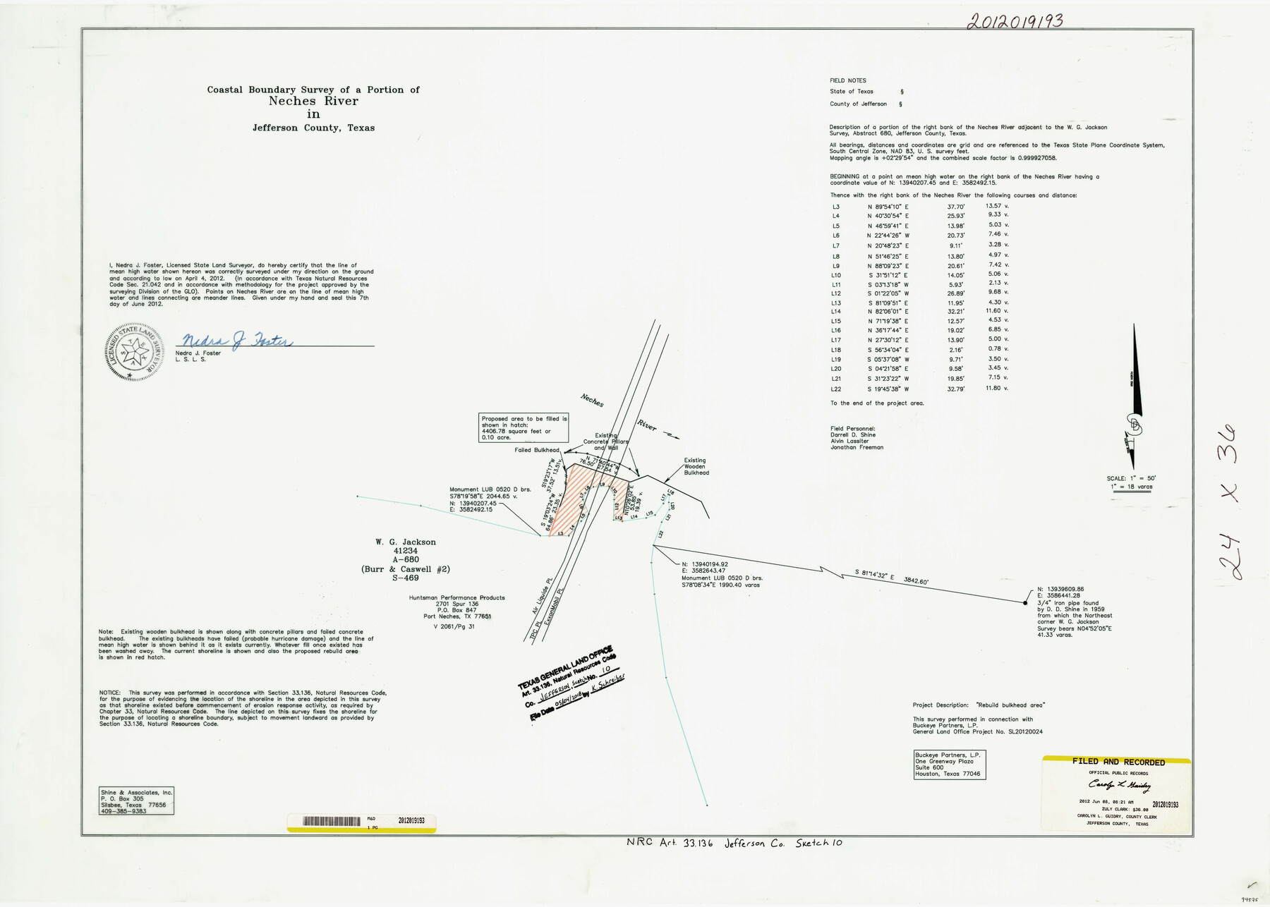
Jefferson County NRC Article 33.136 Sketch 10
Coastal Boundary Survey of a portion of Neches River in Jefferson County, Texas
-
Map/Doc
94575
-
Collection
General Map Collection
-
Object Dates
2012/6/7 (Creation Date)
2018/5/4 (File Date)
-
People and Organizations
Nedra J. Foster (Surveyor/Engineer)
-
Counties
Jefferson
-
Subjects
Surveying CBS
-
Height x Width
24.0 x 36.0 inches
61.0 x 91.4 cm
-
Medium
multi-page, multi-format
-
Comments
Project: Buckeye Partners - Bulkhead Repair Project No.: SL20120024 (GLO)
Part of: General Map Collection
Cooke County Sketch File 31

Print $22.00
- Digital $50.00
Cooke County Sketch File 31
1873
Size 8.0 x 12.9 inches
Map/Doc 19293
Baylor County Boundary File 2

Print $44.00
- Digital $50.00
Baylor County Boundary File 2
Size 8.9 x 25.9 inches
Map/Doc 50359

Gregg County Boundary File 6a

Print $46.00
- Digital $50.00
Gregg County Boundary File 6a
Size 12.7 x 8.2 inches
Map/Doc 54004
Kleberg County Boundary File 2

Print $22.00
- Digital $50.00
Kleberg County Boundary File 2
Size 14.3 x 8.7 inches
Map/Doc 64966
Runnels County Rolled Sketch 50

Print $20.00
- Digital $50.00
Runnels County Rolled Sketch 50
Size 31.3 x 26.7 inches
Map/Doc 7535
Morris County Boundary File 2

Print $6.00
- Digital $50.00
Morris County Boundary File 2
Size 14.1 x 8.7 inches
Map/Doc 57482
McMullen County Working Sketch 11

Print $20.00
- Digital $50.00
McMullen County Working Sketch 11
1938
Size 26.8 x 31.6 inches
Map/Doc 70712

Flight Mission No. BRE-1P, Frame 94, Nueces County

Print $20.00
- Digital $50.00
Flight Mission No. BRE-1P, Frame 94, Nueces County
1956
Size 18.6 x 22.4 inches
Map/Doc 86665
Reconnaissance for Triangulation along the Rio Grande from El Paso to the Gulf of Mexico

Print $20.00
- Digital $50.00
Reconnaissance for Triangulation along the Rio Grande from El Paso to the Gulf of Mexico
Size 16.9 x 22.6 inches
Map/Doc 96558
Flight Mission No. BRE-2P, Frame 22, Nueces County

Print $20.00
- Digital $50.00
Flight Mission No. BRE-2P, Frame 22, Nueces County
1956
Size 18.7 x 22.6 inches
Map/Doc 86731
You may also like
Real County Working Sketch 88

Print $20.00
- Digital $50.00
Real County Working Sketch 88
1989
Size 23.9 x 27.0 inches
Map/Doc 71980
Map showing surveys in Blocks 45, 3, R & 5T

Print $20.00
- Digital $50.00
Map showing surveys in Blocks 45, 3, R & 5T
1913
Size 30.2 x 37.5 inches
Map/Doc 496
Mills County Rolled Sketch 3

Print $20.00
- Digital $50.00
Mills County Rolled Sketch 3
1998
Size 26.4 x 37.9 inches
Map/Doc 6781
Presidio County Sketch File 74

Print $8.00
- Digital $50.00
Presidio County Sketch File 74
1946
Size 11.4 x 8.8 inches
Map/Doc 34687
Walker County Sketch File 3

Print $4.00
- Digital $50.00
Walker County Sketch File 3
1853
Size 12.8 x 8.2 inches
Map/Doc 39551
Controlled Mosaic by Jack Amman Photogrammetric Engineers, Inc - Sheet 39

Print $20.00
- Digital $50.00
Controlled Mosaic by Jack Amman Photogrammetric Engineers, Inc - Sheet 39
1954
Size 20.0 x 24.0 inches
Map/Doc 83494
Burleson County

Print $20.00
- Digital $50.00
Burleson County
1920
Size 40.7 x 45.2 inches
Map/Doc 66740
Map of Fisher and Miller's Colony made from the records in the Office of the District Surveyor of Bexar comprising also all the recent surveys

Print $20.00
- Digital $50.00
Map of Fisher and Miller's Colony made from the records in the Office of the District Surveyor of Bexar comprising also all the recent surveys
1855
Size 23.7 x 35.2 inches
Map/Doc 1971
Stephens County Sketch File 10c

Print $6.00
- Digital $50.00
Stephens County Sketch File 10c
Size 7.8 x 11.5 inches
Map/Doc 37052
Baylor County Aerial Photograph Index Sheet 1

Print $20.00
- Digital $50.00
Baylor County Aerial Photograph Index Sheet 1
1950
Size 21.4 x 17.4 inches
Map/Doc 83663
Presidio County Sketch File K

Print $8.00
- Digital $50.00
Presidio County Sketch File K
1907
Size 13.6 x 8.6 inches
Map/Doc 34456
Map of Matagorda County

Print $20.00
- Digital $50.00
Map of Matagorda County
1839
Size 23.5 x 32.2 inches
Map/Doc 3844