Schleicher County Rolled Sketch 2
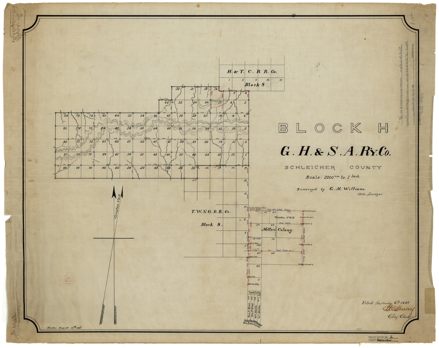
Block H, G. H. & S. A. Ry. Co., Schleicher County
-
Map/Doc
7746
-
Collection
General Map Collection
-
Object Dates
8/15/1888 (Creation Date)
9/6/1888 (File Date)
-
People and Organizations
G.M. Williams (Surveyor/Engineer)
-
Counties
Schleicher
-
Subjects
Surveying Rolled Sketch
-
Height x Width
25.8 x 32.6 inches
65.5 x 82.8 cm
-
Medium
linen, manuscript
-
Scale
1" = 2000 varas
Part of: General Map Collection
Duval County Sketch File 42

Print $4.00
- Digital $50.00
Duval County Sketch File 42
1936
Size 14.4 x 8.8 inches
Map/Doc 21394
Parker County Sketch File 12

Print $4.00
- Digital $50.00
Parker County Sketch File 12
1858
Size 9.1 x 7.1 inches
Map/Doc 33544
Kaufman County Working Sketch 4

Print $40.00
- Digital $50.00
Kaufman County Working Sketch 4
1922
Size 52.1 x 36.2 inches
Map/Doc 66667
Upton County Rolled Sketch 39

Print $40.00
- Digital $50.00
Upton County Rolled Sketch 39
Size 53.4 x 44.1 inches
Map/Doc 10055
Shelby County Working Sketch 1

Print $20.00
- Digital $50.00
Shelby County Working Sketch 1
1917
Size 26.2 x 30.0 inches
Map/Doc 63854
Fannin County Boundary File 10a and 10b and 10c

Print $2.00
- Digital $50.00
Fannin County Boundary File 10a and 10b and 10c
Size 11.2 x 9.1 inches
Map/Doc 53327
Harris County Working Sketch 115

Print $40.00
- Digital $50.00
Harris County Working Sketch 115
1983
Size 48.8 x 44.5 inches
Map/Doc 66007
Colorado County Sketch File 24

Print $20.00
- Digital $50.00
Colorado County Sketch File 24
Size 22.7 x 16.6 inches
Map/Doc 11137
Edwards County Rolled Sketch 7

Print $20.00
- Digital $50.00
Edwards County Rolled Sketch 7
1881
Size 24.4 x 23.2 inches
Map/Doc 5800
Schleicher County Sketch File 27

Print $20.00
- Digital $50.00
Schleicher County Sketch File 27
Size 23.0 x 19.2 inches
Map/Doc 12305
Baylor County Sketch File A10

Print $8.00
- Digital $50.00
Baylor County Sketch File A10
1927
Size 11.3 x 8.9 inches
Map/Doc 14100
Wheeler County Boundary File 1b

Print $2.00
- Digital $50.00
Wheeler County Boundary File 1b
Size 12.3 x 8.8 inches
Map/Doc 59869
You may also like
Lampasas County Boundary File 5

Print $16.00
- Digital $50.00
Lampasas County Boundary File 5
Size 11.1 x 8.7 inches
Map/Doc 56128
Map of the United States with its territories: also Mexico and the West Indies

Print $20.00
- Digital $50.00
Map of the United States with its territories: also Mexico and the West Indies
1851
Size 40.1 x 36.7 inches
Map/Doc 93925
Martin County Rolled Sketch 10A

Print $20.00
- Digital $50.00
Martin County Rolled Sketch 10A
1994
Size 18.3 x 24.5 inches
Map/Doc 6671
Bailey County Sketch File 2a

Print $6.00
- Digital $50.00
Bailey County Sketch File 2a
1892
Size 13.0 x 8.3 inches
Map/Doc 13935
Brewster County Rolled Sketch 60

Print $20.00
- Digital $50.00
Brewster County Rolled Sketch 60
Size 25.0 x 37.5 inches
Map/Doc 8484
Dickens County

Print $20.00
- Digital $50.00
Dickens County
1891
Size 24.5 x 20.2 inches
Map/Doc 4533
Map of the River Sabine from its Mouth on the Gulf of Mexico in the Sea to Logan's Ferry in Latitude 31°58'24" north

Print $40.00
Map of the River Sabine from its Mouth on the Gulf of Mexico in the Sea to Logan's Ferry in Latitude 31°58'24" north
1840
Size 35.0 x 170.0 inches
Map/Doc 88901
Harrison County Sketch File 2

Print $4.00
- Digital $50.00
Harrison County Sketch File 2
1853
Size 8.1 x 9.9 inches
Map/Doc 26034
Wise County Sketch File 25

Print $4.00
- Digital $50.00
Wise County Sketch File 25
1860
Size 12.5 x 8.1 inches
Map/Doc 40572
Hall County Working Sketch 5

Print $20.00
- Digital $50.00
Hall County Working Sketch 5
1938
Size 21.7 x 25.2 inches
Map/Doc 63333
Zavala County Working Sketch 23

Print $40.00
- Digital $50.00
Zavala County Working Sketch 23
1980
Size 77.3 x 43.6 inches
Map/Doc 62098
Flight Mission No. BRE-1P, Frame 27, Nueces County

Print $20.00
- Digital $50.00
Flight Mission No. BRE-1P, Frame 27, Nueces County
1956
Size 18.5 x 22.4 inches
Map/Doc 86622