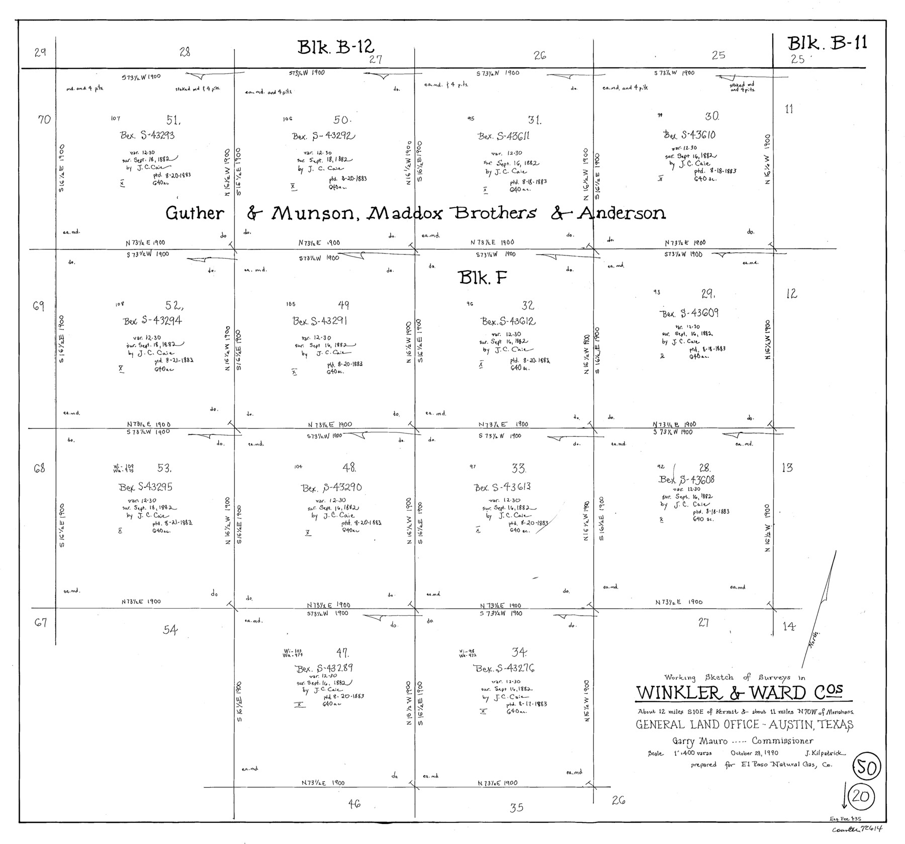
Winkler County Working Sketch 20
-
Map/Doc
72614
-
Collection
General Map Collection
-
Object Dates
10/29/1990 (Creation Date)
-
People and Organizations
Joan Kilpatrick (Draftsman)
-
Counties
Winkler Ward
-
Subjects
Surveying Working Sketch
-
Height x Width
22.3 x 24.0 inches
56.6 x 61.0 cm
-
Scale
1" = 400 varas
Part of: General Map Collection
Flight Mission No. BRA-8M, Frame 88, Jefferson County

Print $20.00
- Digital $50.00
Flight Mission No. BRA-8M, Frame 88, Jefferson County
1953
Size 18.6 x 22.3 inches
Map/Doc 85608
Map of the Lands Surveyed by the Memphis, El Paso & Pacific R.R. Company

Print $20.00
- Digital $50.00
Map of the Lands Surveyed by the Memphis, El Paso & Pacific R.R. Company
1859
Size 15.0 x 30.0 inches
Map/Doc 2219
[Missouri, Kansas & Texas] E. L. & R. R. Railroad, Morris Co.
![64273, [Missouri, Kansas & Texas] E. L. & R. R. Railroad, Morris Co., General Map Collection](https://historictexasmaps.com/wmedia_w700/maps/64273.tif.jpg)
Print $20.00
- Digital $50.00
[Missouri, Kansas & Texas] E. L. & R. R. Railroad, Morris Co.
1906
Size 13.1 x 28.4 inches
Map/Doc 64273
Dimmit County Working Sketch 37

Print $20.00
- Digital $50.00
Dimmit County Working Sketch 37
1962
Size 28.9 x 25.6 inches
Map/Doc 68698
State University and PSL Blocks 1 through 77 in Andrews, Culberson, Crane, Ector, El Paso, Gaines, Loving, Martin, Reeves, Tom Green, Ward County, and Winkler Counties

State University and PSL Blocks 1 through 77 in Andrews, Culberson, Crane, Ector, El Paso, Gaines, Loving, Martin, Reeves, Tom Green, Ward County, and Winkler Counties
Map/Doc 81652
Lampasas County Sketch File 15

Print $20.00
- Digital $50.00
Lampasas County Sketch File 15
1888
Size 24.5 x 27.1 inches
Map/Doc 11975
Flight Mission No. CON-4R, Frame 200, Stonewall County

Print $20.00
- Digital $50.00
Flight Mission No. CON-4R, Frame 200, Stonewall County
1957
Size 18.2 x 22.0 inches
Map/Doc 86994
Atascosa County Working Sketch 18

Print $20.00
- Digital $50.00
Atascosa County Working Sketch 18
1950
Size 43.2 x 25.8 inches
Map/Doc 67214
Val Verde County Working Sketch 14

Print $20.00
- Digital $50.00
Val Verde County Working Sketch 14
1926
Size 17.2 x 18.9 inches
Map/Doc 72149
Map of Irion County

Print $20.00
- Digital $50.00
Map of Irion County
1893
Size 43.6 x 37.3 inches
Map/Doc 16857

San Patricio County Sketch File 40

Print $4.00
- Digital $50.00
San Patricio County Sketch File 40
1842
Size 10.5 x 8.2 inches
Map/Doc 36236
You may also like
Galveston County NRC Article 33.136 Sketch 25

Print $26.00
- Digital $50.00
Galveston County NRC Article 33.136 Sketch 25
1999
Size 36.0 x 23.9 inches
Map/Doc 81906
Baylor County Sketch File 1a

Print $8.00
- Digital $50.00
Baylor County Sketch File 1a
1857
Size 8.2 x 7.9 inches
Map/Doc 14144
Map of Defunct and Ghost Counties in Texas

Print $20.00
- Digital $50.00
Map of Defunct and Ghost Counties in Texas
1939
Size 35.0 x 35.9 inches
Map/Doc 2148
[Surveys in the Jefferson District: G. A. Patillo's league, Big Sandy, Sabine Bay]
![69727, [Surveys in the Jefferson District: G. A. Patillo's league, Big Sandy, Sabine Bay], General Map Collection](https://historictexasmaps.com/wmedia_w700/maps/69727-1.tif.jpg)
Print $20.00
- Digital $50.00
[Surveys in the Jefferson District: G. A. Patillo's league, Big Sandy, Sabine Bay]
1846
Size 14.4 x 20.9 inches
Map/Doc 69727
Houston County

Print $20.00
- Digital $50.00
Houston County
1868
Size 24.3 x 25.0 inches
Map/Doc 4568
Colorado River, Hungerford Sheet

Print $6.00
- Digital $50.00
Colorado River, Hungerford Sheet
1941
Size 24.1 x 35.4 inches
Map/Doc 65309
Hutchinson County Rolled Sketch 39

Print $20.00
- Digital $50.00
Hutchinson County Rolled Sketch 39
1956
Size 29.5 x 32.1 inches
Map/Doc 7712
Webb County Boundary File 3

Print $74.00
- Digital $50.00
Webb County Boundary File 3
Size 11.3 x 8.8 inches
Map/Doc 59716
Cameron County Sketch File 6

Print $20.00
- Digital $50.00
Cameron County Sketch File 6
1970
Size 11.0 x 8.5 inches
Map/Doc 17032
Coast Chart No. 210 Aransas Pass and Corpus Christi Bay with the coast to latitude 27° 12' Texas

Print $20.00
- Digital $50.00
Coast Chart No. 210 Aransas Pass and Corpus Christi Bay with the coast to latitude 27° 12' Texas
1913
Size 27.4 x 18.3 inches
Map/Doc 72797
Map of Gray County

Print $20.00
- Digital $50.00
Map of Gray County
1900
Size 43.4 x 40.5 inches
Map/Doc 95511
Flight Mission No. CRC-4R, Frame 80, Chambers County

Print $20.00
- Digital $50.00
Flight Mission No. CRC-4R, Frame 80, Chambers County
1956
Size 18.6 x 22.4 inches
Map/Doc 84884