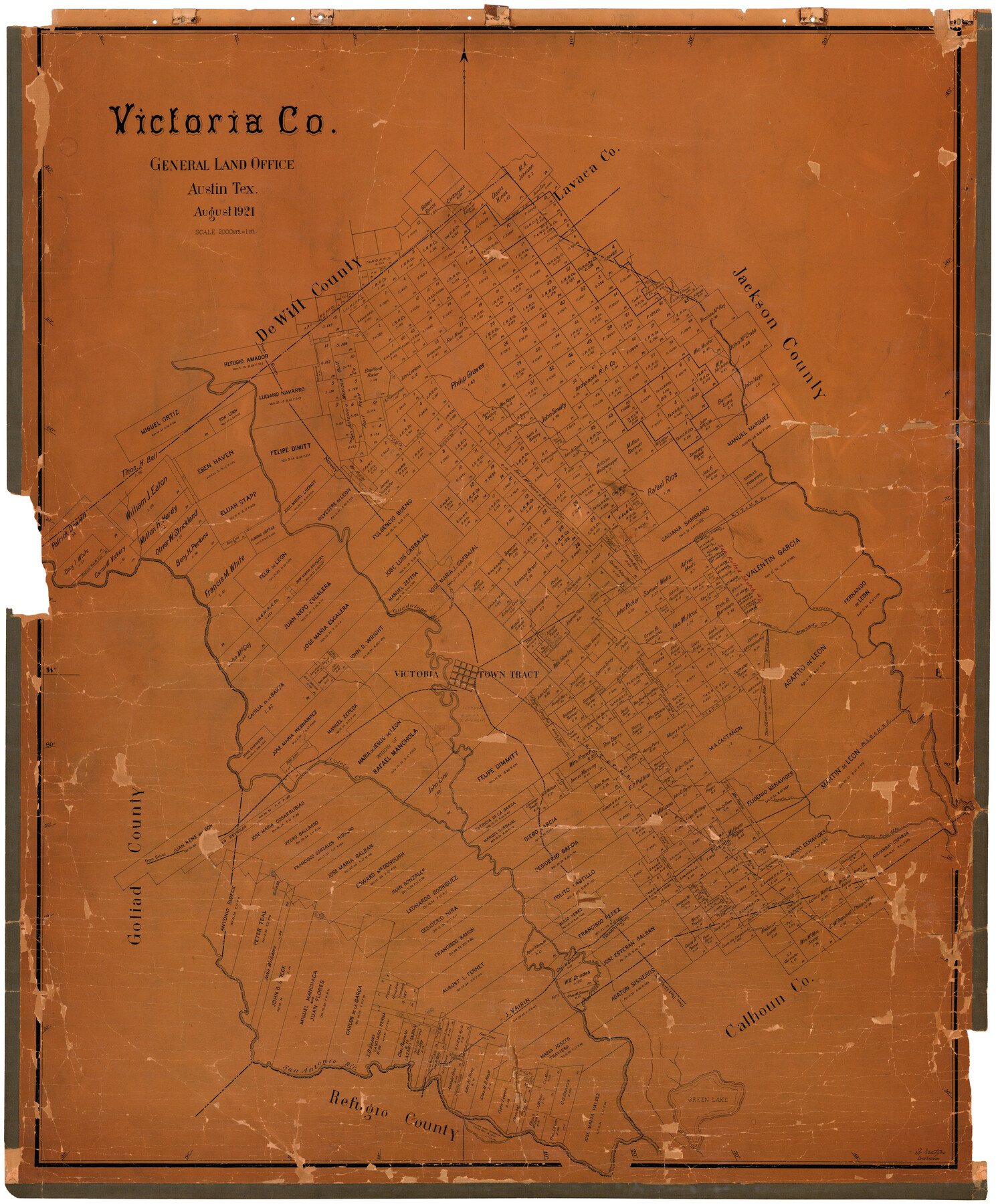
Victoria Co.
-
Map/Doc
73313
-
Collection
General Map Collection
-
Object Dates
1921 (Creation Date)
-
People and Organizations
Texas General Land Office (Publisher)
Fr. Matzow (Draftsman)
-
Counties
Victoria
-
Subjects
County
-
Height x Width
47.6 x 40.1 inches
120.9 x 101.9 cm
-
Comments
Hand lettered.
-
Features
[Road] from Port O'Connor
Green Lake
[Road] from Goliad
Placedo
Arroyo Palo Alto
Coleto Creek
GWT&P
Telfener
Proposed Texas Railroad
Nursery
NYT&M
Arenoso Creek
San Antonio River
[Road] from Cuero
Chocolate Creek
Bloomington
Traylors Bayou
Zorilla Creek
SLB&M
Victoria
Marcado Creek
Garcitas Creek
Spring Creek
Guadalupe River
[Road] to Yoakum
Part of: General Map Collection
Cherokee County Working Sketch 23

Print $20.00
- Digital $50.00
Cherokee County Working Sketch 23
1972
Size 44.4 x 46.9 inches
Map/Doc 67978
Harris County Working Sketch 61

Print $20.00
- Digital $50.00
Harris County Working Sketch 61
1954
Size 22.2 x 24.3 inches
Map/Doc 65953
Jeff Davis County Working Sketch 42

Print $20.00
- Digital $50.00
Jeff Davis County Working Sketch 42
1983
Size 42.7 x 46.7 inches
Map/Doc 66537
Howard County Working Sketch 7a

Print $40.00
- Digital $50.00
Howard County Working Sketch 7a
1950
Size 81.9 x 24.7 inches
Map/Doc 66273
Stephens County

Print $20.00
- Digital $50.00
Stephens County
1940
Size 40.3 x 38.9 inches
Map/Doc 77426
Upton County Sketch File 27

Print $20.00
- Digital $50.00
Upton County Sketch File 27
1928
Size 42.9 x 22.6 inches
Map/Doc 10416
Roberts County Working Sketch 12

Print $20.00
- Digital $50.00
Roberts County Working Sketch 12
Size 25.5 x 22.5 inches
Map/Doc 63538
PSL Field Notes for Blocks G, L, P, and Q in Cochran and Yoakum Counties and Blocks U, V, W, Y, and Z in Cochran County

PSL Field Notes for Blocks G, L, P, and Q in Cochran and Yoakum Counties and Blocks U, V, W, Y, and Z in Cochran County
Map/Doc 81645
Frio County Working Sketch 12

Print $40.00
- Digital $50.00
Frio County Working Sketch 12
1953
Size 52.8 x 39.9 inches
Map/Doc 69286
Coke County Working Sketch 10

Print $20.00
- Digital $50.00
Coke County Working Sketch 10
1937
Size 25.1 x 26.7 inches
Map/Doc 68047
Dallas County Boundary File 1

Print $62.00
- Digital $50.00
Dallas County Boundary File 1
Size 4.1 x 3.7 inches
Map/Doc 52084
United States - Gulf Coast Texas - Northern part of Laguna Madre

Print $20.00
- Digital $50.00
United States - Gulf Coast Texas - Northern part of Laguna Madre
1941
Size 26.7 x 18.4 inches
Map/Doc 72933
You may also like
Maverick County Working Sketch 19

Print $40.00
- Digital $50.00
Maverick County Working Sketch 19
1975
Size 56.2 x 44.0 inches
Map/Doc 70911
Map of Brazoria County

Print $40.00
- Digital $50.00
Map of Brazoria County
1891
Size 56.9 x 58.4 inches
Map/Doc 16945
Flight Mission No. DQO-2K, Frame 147, Galveston County

Print $20.00
- Digital $50.00
Flight Mission No. DQO-2K, Frame 147, Galveston County
1952
Size 18.8 x 22.6 inches
Map/Doc 85044
The Pirson Colony. November 18, 1842

Print $20.00
The Pirson Colony. November 18, 1842
2020
Size 22.2 x 21.7 inches
Map/Doc 96370

Map of Pecos Co.

Print $40.00
- Digital $50.00
Map of Pecos Co.
1896
Size 47.7 x 70.1 inches
Map/Doc 76038
Rusk County Rolled Sketch 5

Print $40.00
- Digital $50.00
Rusk County Rolled Sketch 5
1948
Size 36.9 x 49.5 inches
Map/Doc 10744
Real County Rolled Sketch 18

Print $20.00
- Digital $50.00
Real County Rolled Sketch 18
Size 22.0 x 28.0 inches
Map/Doc 7464
Jeff Davis County Sketch File R

Print $12.00
- Digital $50.00
Jeff Davis County Sketch File R
Size 6.0 x 8.7 inches
Map/Doc 28017
Zavala County Sketch File 21

Print $4.00
- Digital $50.00
Zavala County Sketch File 21
1915
Size 11.5 x 8.8 inches
Map/Doc 41376
Aransas County Sketch File 2

Print $4.00
- Digital $50.00
Aransas County Sketch File 2
Size 7.4 x 5.0 inches
Map/Doc 13100
Anderson County Boundary File 4

Print $10.00
- Digital $50.00
Anderson County Boundary File 4
Size 8.9 x 7.4 inches
Map/Doc 49737