Jack County Sketch File 18
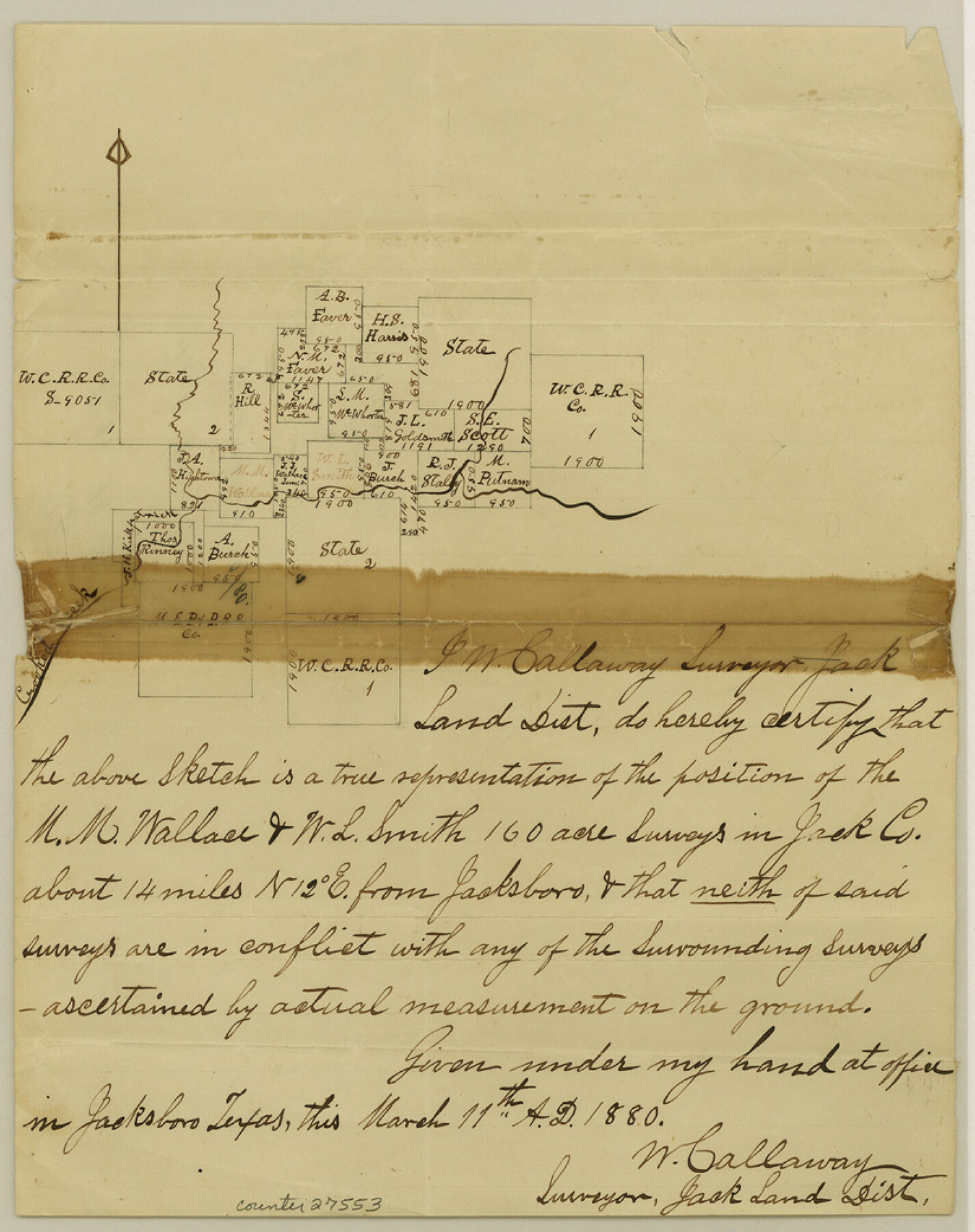
[Sketch showing the position of the M.M. Wallace and W.L. Smith surveys in the vicinity of Crooked Creek in the north part of the county]
-
Map/Doc
27553
-
Collection
General Map Collection
-
Object Dates
3/11/1880 (Creation Date)
3/20/1880 (File Date)
-
People and Organizations
Wesley Callaway (Surveyor/Engineer)
-
Counties
Jack
-
Subjects
Surveying Sketch File
-
Height x Width
10.4 x 8.2 inches
26.4 x 20.8 cm
-
Medium
paper, manuscript
-
Features
Crooked Creek
Part of: General Map Collection
Atascosa County Sketch File 12

Print $4.00
- Digital $50.00
Atascosa County Sketch File 12
1862
Size 14.4 x 8.3 inches
Map/Doc 13769
Bandera County Working Sketch 8

Print $20.00
- Digital $50.00
Bandera County Working Sketch 8
1920
Size 16.6 x 20.8 inches
Map/Doc 67601
Chambers County NRC Article 33.136 Sketch 2

Print $2.00
- Digital $50.00
Chambers County NRC Article 33.136 Sketch 2
2004
Size 8.2 x 10.8 inches
Map/Doc 82998
Hardin County Rolled Sketch 3

Print $20.00
- Digital $50.00
Hardin County Rolled Sketch 3
1902
Size 20.1 x 17.0 inches
Map/Doc 6076
La Salle County Sketch File 42 and 42a

Print $28.00
- Digital $50.00
La Salle County Sketch File 42 and 42a
1926
Size 11.1 x 8.9 inches
Map/Doc 29597
Ward County Working Sketch 16

Print $20.00
- Digital $50.00
Ward County Working Sketch 16
1948
Size 29.6 x 33.9 inches
Map/Doc 72322
Waller County Sketch File 7

Print $4.00
- Digital $50.00
Waller County Sketch File 7
1873
Size 9.4 x 8.2 inches
Map/Doc 39608
Foard County Sketch File 14

Print $4.00
- Digital $50.00
Foard County Sketch File 14
1885
Size 14.4 x 8.8 inches
Map/Doc 22819
Supreme Court of the United States, October Term, 1923, No. 15, Original - The State of Oklahoma, Complainant vs. The State of Texas, Defendant, The United States, Intervener; Report of the Boundary Commissioners

Print $40.00
- Digital $50.00
Supreme Court of the United States, October Term, 1923, No. 15, Original - The State of Oklahoma, Complainant vs. The State of Texas, Defendant, The United States, Intervener; Report of the Boundary Commissioners
1923
Size 57.5 x 33.4 inches
Map/Doc 77591
Flight Mission No. CRK-5P, Frame 126, Refugio County

Print $20.00
- Digital $50.00
Flight Mission No. CRK-5P, Frame 126, Refugio County
1956
Size 18.7 x 22.4 inches
Map/Doc 86929
[Surveys near the Guadalupe River]
![288, [Surveys near the Guadalupe River], General Map Collection](https://historictexasmaps.com/wmedia_w700/maps/288.tif.jpg)
Print $2.00
- Digital $50.00
[Surveys near the Guadalupe River]
1847
Size 8.8 x 7.9 inches
Map/Doc 288
Kinney County Working Sketch 39

Print $20.00
- Digital $50.00
Kinney County Working Sketch 39
1972
Size 37.7 x 44.8 inches
Map/Doc 70221
You may also like
Map of Franklin County

Print $20.00
- Digital $50.00
Map of Franklin County
1879
Size 21.1 x 10.4 inches
Map/Doc 3560
[Northwest corner of the County]
![90873, [Northwest corner of the County], Twichell Survey Records](https://historictexasmaps.com/wmedia_w700/maps/90873-2.tif.jpg)
Print $20.00
- Digital $50.00
[Northwest corner of the County]
1903
Size 19.1 x 21.5 inches
Map/Doc 90873
Ochiltree County Boundary File 1c

Print $2.00
- Digital $50.00
Ochiltree County Boundary File 1c
Size 10.6 x 8.1 inches
Map/Doc 57674
Flight Mission No. CGI-3N, Frame 97, Cameron County

Print $20.00
- Digital $50.00
Flight Mission No. CGI-3N, Frame 97, Cameron County
1954
Size 18.6 x 22.1 inches
Map/Doc 84577
Ownership Map NE 1/4 Lubbock County

Print $20.00
- Digital $50.00
Ownership Map NE 1/4 Lubbock County
Size 37.5 x 39.8 inches
Map/Doc 89896
Map of Upshur County Showing Location T&P R.

Print $20.00
- Digital $50.00
Map of Upshur County Showing Location T&P R.
1872
Size 26.5 x 19.4 inches
Map/Doc 64137
San Jacinto County Sketch File 14

Print $20.00
San Jacinto County Sketch File 14
Size 15.8 x 18.2 inches
Map/Doc 12281
Reeves County Working Sketch 19

Print $20.00
- Digital $50.00
Reeves County Working Sketch 19
1962
Size 42.3 x 42.7 inches
Map/Doc 63462
[Sketch showing part of H. & G. N. Block 1]
![89633, [Sketch showing part of H. & G. N. Block 1], Twichell Survey Records](https://historictexasmaps.com/wmedia_w700/maps/89633-1.tif.jpg)
Print $40.00
- Digital $50.00
[Sketch showing part of H. & G. N. Block 1]
Size 20.0 x 54.4 inches
Map/Doc 89633
Duval County Rolled Sketch 20A

Print $20.00
- Digital $50.00
Duval County Rolled Sketch 20A
Size 34.6 x 43.7 inches
Map/Doc 8816
Clay County Working Sketch 1

Print $20.00
- Digital $50.00
Clay County Working Sketch 1
Size 30.7 x 29.3 inches
Map/Doc 68024
Tarrant County Rolled Sketch 2

Print $40.00
- Digital $50.00
Tarrant County Rolled Sketch 2
Size 91.5 x 13.4 inches
Map/Doc 78246