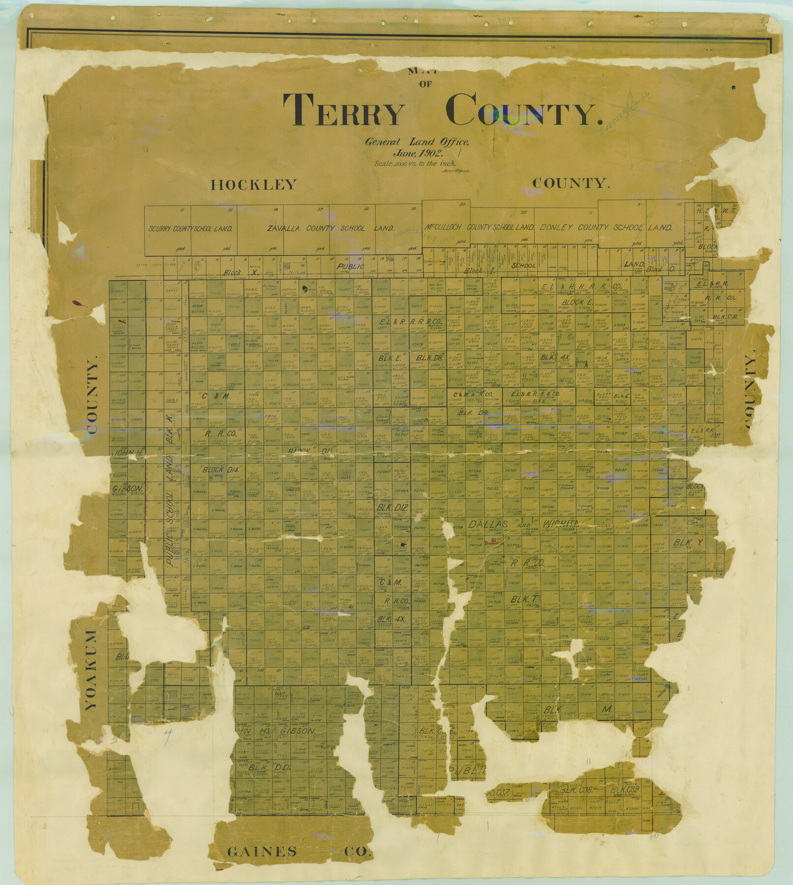
Map of Terry County
-
Map/Doc
16893
-
Collection
General Map Collection
-
Object Dates
1902 (Creation Date)
-
People and Organizations
Texas General Land Office (Publisher)
Amos Wynne (Draftsman)
Amos Wynne (Compiler)
-
Counties
Terry
-
Subjects
County
-
Height x Width
45.6 x 40.8 inches
115.8 x 103.6 cm
-
Comments
Help Save Texas History - Adopt Me!
-
Features
Brownfield
Gomez
Santa Fe Railway (proposed)
Part of: General Map Collection
Presidio County Working Sketch 84

Print $20.00
- Digital $50.00
Presidio County Working Sketch 84
1970
Size 20.7 x 17.8 inches
Map/Doc 71761
Maps of Gulf Intracoastal Waterway, Texas - Sabine River to the Rio Grande and connecting waterways including ship channels

Print $20.00
- Digital $50.00
Maps of Gulf Intracoastal Waterway, Texas - Sabine River to the Rio Grande and connecting waterways including ship channels
1966
Size 15.7 x 22.0 inches
Map/Doc 61986
Parker County Working Sketch 2

Print $20.00
- Digital $50.00
Parker County Working Sketch 2
1920
Map/Doc 71452
Blanco County Boundary File 8

Print $20.00
- Digital $50.00
Blanco County Boundary File 8
Size 20.1 x 11.1 inches
Map/Doc 50575
Flight Mission No. BQR-20K, Frame 10, Brazoria County

Print $20.00
- Digital $50.00
Flight Mission No. BQR-20K, Frame 10, Brazoria County
1952
Size 18.6 x 22.3 inches
Map/Doc 84112
Nueces County Sketch File 21

Print $8.00
- Digital $50.00
Nueces County Sketch File 21
1880
Size 5.9 x 5.5 inches
Map/Doc 32557
Dawson County Sketch File 9

Print $4.00
- Digital $50.00
Dawson County Sketch File 9
1925
Size 11.3 x 8.7 inches
Map/Doc 20542
Dawson County

Print $20.00
- Digital $50.00
Dawson County
1959
Size 42.4 x 34.8 inches
Map/Doc 73127
Midland County Sketch File 17

Print $26.00
- Digital $50.00
Midland County Sketch File 17
1955
Size 11.2 x 8.7 inches
Map/Doc 31582
Hutchinson County Sketch File 50

Print $12.00
- Digital $50.00
Hutchinson County Sketch File 50
1992
Size 14.2 x 8.8 inches
Map/Doc 27434
Flight Mission No. CUG-3P, Frame 79, Kleberg County

Print $20.00
- Digital $50.00
Flight Mission No. CUG-3P, Frame 79, Kleberg County
1956
Size 18.4 x 22.2 inches
Map/Doc 86254
Flight Mission No. DAG-28K, Frame 30, Matagorda County

Print $20.00
- Digital $50.00
Flight Mission No. DAG-28K, Frame 30, Matagorda County
1953
Size 16.1 x 16.1 inches
Map/Doc 86598
You may also like
Cameron County Sketch File 17

Print $24.00
- Digital $50.00
Cameron County Sketch File 17
2009
Size 11.0 x 8.5 inches
Map/Doc 95191
Flight Mission No. BRA-7M, Frame 8, Jefferson County

Print $20.00
- Digital $50.00
Flight Mission No. BRA-7M, Frame 8, Jefferson County
1953
Size 18.6 x 22.4 inches
Map/Doc 85459
Denton County Sketch File 24

Print $40.00
- Digital $50.00
Denton County Sketch File 24
1862
Size 12.2 x 15.1 inches
Map/Doc 20750
Hamilton County Working Sketch 29

Print $20.00
- Digital $50.00
Hamilton County Working Sketch 29
1981
Size 43.3 x 38.0 inches
Map/Doc 63367
Waller County Sketch File 2a

Print $4.00
- Digital $50.00
Waller County Sketch File 2a
Size 8.0 x 8.4 inches
Map/Doc 39596
Map showing resurvey of Capitol Leagues, Oldham Co., Texas

Print $40.00
- Digital $50.00
Map showing resurvey of Capitol Leagues, Oldham Co., Texas
1918
Size 38.6 x 51.0 inches
Map/Doc 1755
Robertson & Scott V Ranch situated in Crosby County, Texas

Print $40.00
- Digital $50.00
Robertson & Scott V Ranch situated in Crosby County, Texas
Size 41.2 x 48.8 inches
Map/Doc 89758
Pecos County Sketch File 24

Print $22.00
- Digital $50.00
Pecos County Sketch File 24
Size 7.6 x 5.6 inches
Map/Doc 33680
Panola County Sketch File 4

Print $4.00
- Digital $50.00
Panola County Sketch File 4
1860
Size 8.9 x 8.9 inches
Map/Doc 33449
General Highway Map, Fisher County, Texas

Print $20.00
General Highway Map, Fisher County, Texas
1940
Size 18.5 x 25.0 inches
Map/Doc 79090
Val Verde County Sketch File 40

Print $20.00
- Digital $50.00
Val Verde County Sketch File 40
1939
Size 15.3 x 25.5 inches
Map/Doc 12582
Howard County Working Sketch 8

Print $20.00
- Digital $50.00
Howard County Working Sketch 8
1956
Size 25.3 x 31.3 inches
Map/Doc 66275