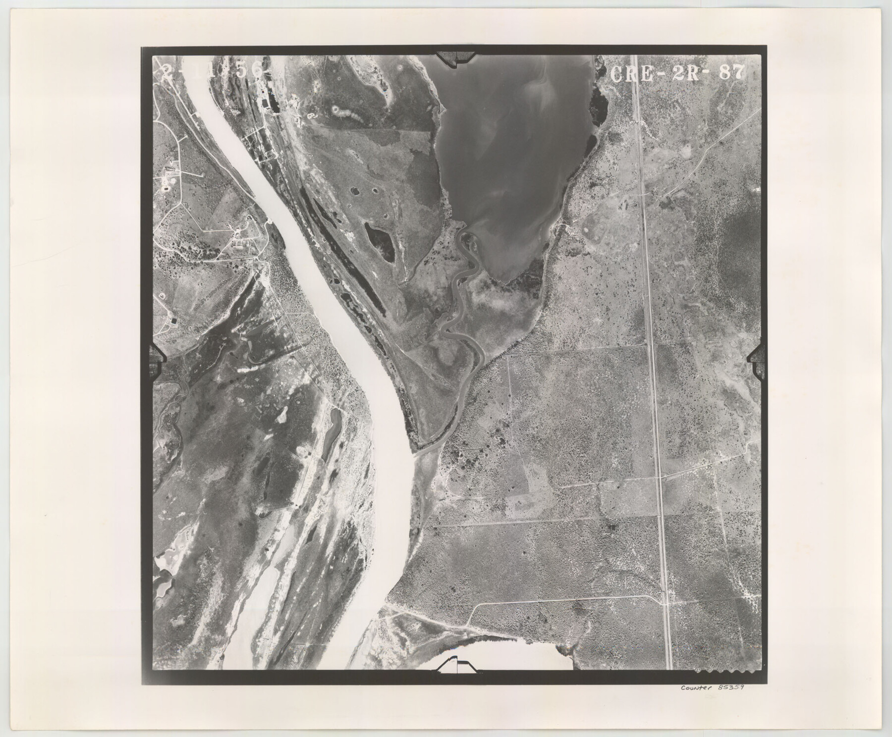
Flight Mission No. CRE-2R, Frame 87, Jackson County
CRE-2R-87
-
Map/Doc
85359
-
Collection
General Map Collection
-
Object Dates
1956/2/11 (Creation Date)
-
People and Organizations
U. S. Department of Agriculture (Publisher)
-
Counties
Jackson
-
Subjects
Aerial Photograph
-
Height x Width
18.5 x 22.3 inches
47.0 x 56.6 cm
-
Comments
Flown by Jack Ammann Photogrammetric Engineers of San Antonio, Texas.
Part of: General Map Collection
Rockwall County Boundary File 9

Print $8.00
- Digital $50.00
Rockwall County Boundary File 9
Size 15.9 x 9.0 inches
Map/Doc 58433
Nueces County Sketch File 86

Print $2.00
- Digital $50.00
Nueces County Sketch File 86
Map/Doc 81935
Traced from Genl. Arista's map captured by the American Army under Genl. Taylor at Resaca de la Palma 9th May '46 and presented to James K. Polk, President U. States

Print $20.00
- Digital $50.00
Traced from Genl. Arista's map captured by the American Army under Genl. Taylor at Resaca de la Palma 9th May '46 and presented to James K. Polk, President U. States
1846
Size 18.4 x 27.6 inches
Map/Doc 73059
Wood County Working Sketch 2

Print $20.00
- Digital $50.00
Wood County Working Sketch 2
1913
Size 17.8 x 16.8 inches
Map/Doc 62002
Chambers County Sketch File 13

Print $6.00
- Digital $50.00
Chambers County Sketch File 13
1873
Size 9.8 x 12.4 inches
Map/Doc 17558
Stonewall County Rolled Sketch 14

Print $20.00
- Digital $50.00
Stonewall County Rolled Sketch 14
1902
Size 32.9 x 25.2 inches
Map/Doc 7869
Flight Mission No. CGI-1N, Frame 140, Cameron County

Print $20.00
- Digital $50.00
Flight Mission No. CGI-1N, Frame 140, Cameron County
1955
Size 18.7 x 22.3 inches
Map/Doc 84496
Mason County Working Sketch 5

Print $20.00
- Digital $50.00
Mason County Working Sketch 5
1935
Size 12.1 x 18.5 inches
Map/Doc 70841
Map of the City of Galveston Situated on the East end of Galveston Island

Print $20.00
- Digital $50.00
Map of the City of Galveston Situated on the East end of Galveston Island
1838
Size 22.0 x 38.1 inches
Map/Doc 2170
Bandera County Working Sketch 41

Print $20.00
- Digital $50.00
Bandera County Working Sketch 41
1977
Size 31.3 x 37.7 inches
Map/Doc 67637

Map of Chambers Co.

Print $20.00
- Digital $50.00
Map of Chambers Co.
1901
Size 24.9 x 25.1 inches
Map/Doc 4907
You may also like
Flight Mission No. DIX-5P, Frame 149, Aransas County

Print $20.00
- Digital $50.00
Flight Mission No. DIX-5P, Frame 149, Aransas County
1956
Size 17.8 x 17.8 inches
Map/Doc 83811
Kimble County Working Sketch 84

Print $20.00
- Digital $50.00
Kimble County Working Sketch 84
1972
Size 32.5 x 30.7 inches
Map/Doc 70152
No. 1 - Survey for a road from the Brazo Santiago to the Rio Grande

Print $20.00
- Digital $50.00
No. 1 - Survey for a road from the Brazo Santiago to the Rio Grande
1847
Size 18.3 x 27.2 inches
Map/Doc 72878
Marion County Working Sketch 36

Print $20.00
- Digital $50.00
Marion County Working Sketch 36
1987
Size 23.5 x 28.9 inches
Map/Doc 70812
Duval County Rolled Sketch 37

Print $20.00
- Digital $50.00
Duval County Rolled Sketch 37
Size 19.8 x 16.5 inches
Map/Doc 5754
Sketch in Castro County

Print $2.00
- Digital $50.00
Sketch in Castro County
1888
Size 7.8 x 7.9 inches
Map/Doc 90388
Flight Mission No. CRC-3R, Frame 43, Chambers County

Print $20.00
- Digital $50.00
Flight Mission No. CRC-3R, Frame 43, Chambers County
1956
Size 18.5 x 22.3 inches
Map/Doc 84816
Montague County

Print $20.00
- Digital $50.00
Montague County
1875
Size 24.6 x 21.1 inches
Map/Doc 3884
Hays County Boundary File 1

Print $14.00
- Digital $50.00
Hays County Boundary File 1
Size 9.5 x 5.2 inches
Map/Doc 54586
Burnet County Sketch File 27a

Print $10.00
- Digital $50.00
Burnet County Sketch File 27a
1876
Size 8.7 x 8.2 inches
Map/Doc 16732
Map of Mason County

Print $20.00
- Digital $50.00
Map of Mason County
1859
Size 28.4 x 22.4 inches
Map/Doc 3838
Duval County Rolled Sketch 49
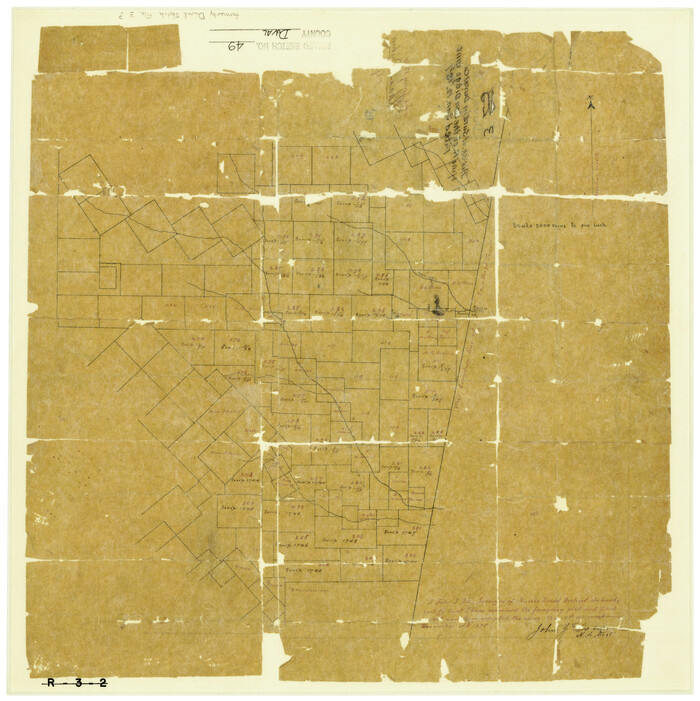
Print $20.00
- Digital $50.00
Duval County Rolled Sketch 49
1875
Size 17.8 x 17.6 inches
Map/Doc 5763