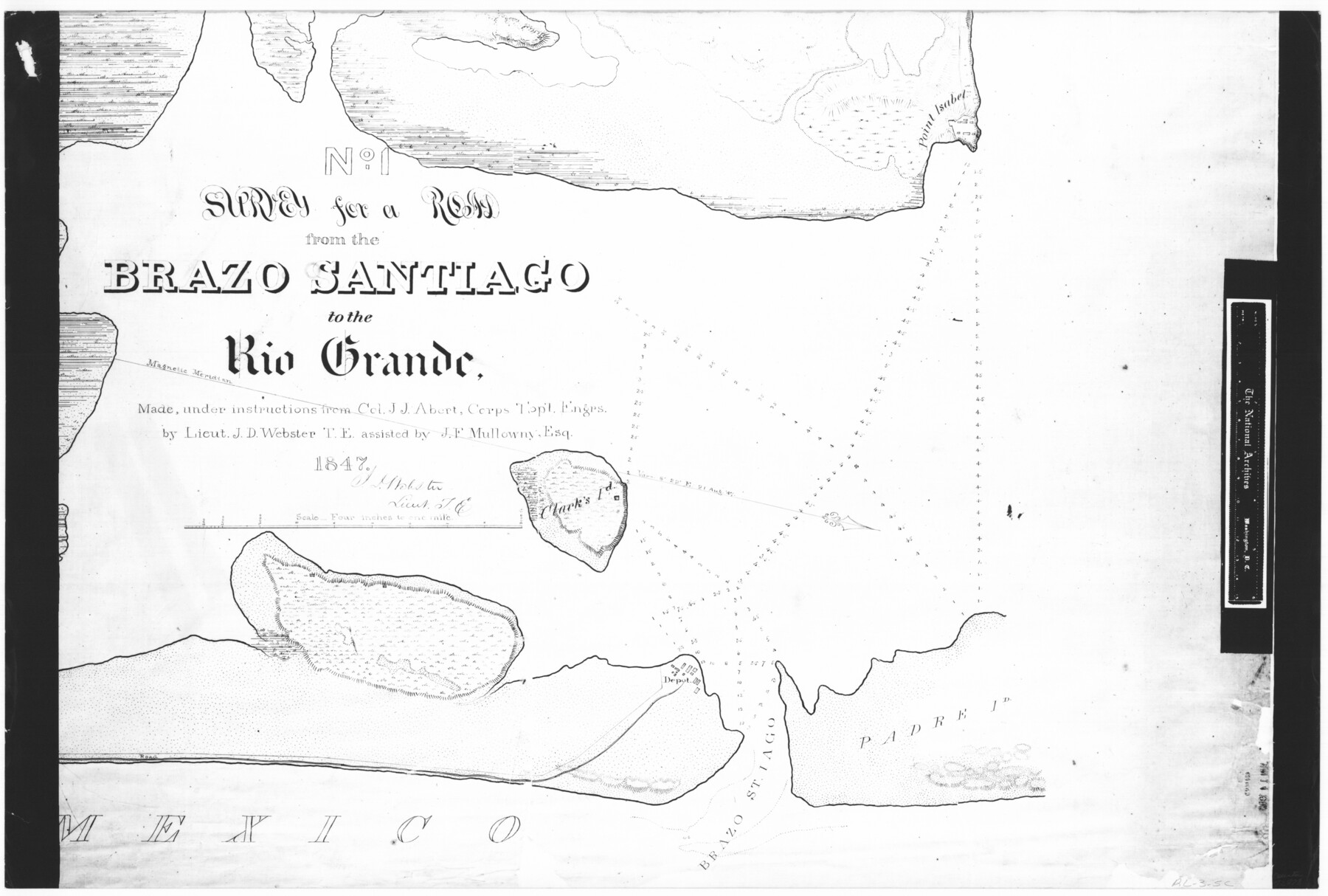
No. 1 - Survey for a road from the Brazo Santiago to the Rio Grande
RL-3-5c
-
Map/Doc
72878
-
Collection
General Map Collection
-
Object Dates
1847 (Creation Date)
-
People and Organizations
Corps of Topographical Engineers (Author)
J.D. Webster (Surveyor/Engineer)
J.F. Mullowny (Surveyor/Engineer)
-
Subjects
River Surveys
-
Height x Width
18.3 x 27.2 inches
46.5 x 69.1 cm
-
Comments
B/W photostat copy from National Archives in multiple pieces.
Part of: General Map Collection
Amistad International Reservoir on Rio Grande 64

Print $20.00
- Digital $50.00
Amistad International Reservoir on Rio Grande 64
1949
Size 28.4 x 39.6 inches
Map/Doc 73349
Flight Mission No. DQN-5K, Frame 50, Calhoun County

Print $20.00
- Digital $50.00
Flight Mission No. DQN-5K, Frame 50, Calhoun County
1953
Size 18.5 x 22.3 inches
Map/Doc 84395
Fannin County Sketch File 20

Print $14.00
- Digital $50.00
Fannin County Sketch File 20
1889
Size 4.2 x 5.1 inches
Map/Doc 22475
Sabine Bank to East Bay including Heald Bank

Print $20.00
- Digital $50.00
Sabine Bank to East Bay including Heald Bank
1973
Size 44.8 x 34.5 inches
Map/Doc 69850
Dimmit County Boundary File 4

Print $14.00
- Digital $50.00
Dimmit County Boundary File 4
Size 14.1 x 8.8 inches
Map/Doc 52570
Kerr County Working Sketch 8

Print $20.00
- Digital $50.00
Kerr County Working Sketch 8
1948
Size 18.1 x 23.6 inches
Map/Doc 70039
[Sketch for Mineral Application 35811 - Liberty County, John Mecom]
![65619, [Sketch for Mineral Application 35811 - Liberty County, John Mecom], General Map Collection](https://historictexasmaps.com/wmedia_w700/maps/65619.tif.jpg)
Print $4.00
- Digital $50.00
[Sketch for Mineral Application 35811 - Liberty County, John Mecom]
1941
Size 24.9 x 20.0 inches
Map/Doc 65619
Galveston County Sketch File 15

Print $4.00
- Digital $50.00
Galveston County Sketch File 15
Size 6.7 x 3.7 inches
Map/Doc 23382
McMullen County Working Sketch 57

Print $20.00
- Digital $50.00
McMullen County Working Sketch 57
1983
Size 29.5 x 18.8 inches
Map/Doc 70758
Coryell County Working Sketch 9

Print $20.00
- Digital $50.00
Coryell County Working Sketch 9
1947
Size 28.7 x 30.0 inches
Map/Doc 68216
La table des isles neufues, lesquelles on appelle isles d'occident & d'Indie pour divers regardz

Print $20.00
- Digital $50.00
La table des isles neufues, lesquelles on appelle isles d'occident & d'Indie pour divers regardz
1552
Size 12.3 x 15.7 inches
Map/Doc 95836
Leon County Rolled Sketch 6

Print $20.00
- Digital $50.00
Leon County Rolled Sketch 6
1951
Size 31.7 x 37.1 inches
Map/Doc 6596
You may also like
Webb County Working Sketch 77

Print $20.00
- Digital $50.00
Webb County Working Sketch 77
1976
Size 25.8 x 26.1 inches
Map/Doc 72444
Right of Way & Track Map San Antonio & Aransas Pass Railway Co.

Print $40.00
- Digital $50.00
Right of Way & Track Map San Antonio & Aransas Pass Railway Co.
1919
Size 25.1 x 56.7 inches
Map/Doc 64026
Flight Mission No. BRE-1P, Frame 117, Nueces County

Print $20.00
- Digital $50.00
Flight Mission No. BRE-1P, Frame 117, Nueces County
1956
Size 18.4 x 22.3 inches
Map/Doc 86683
Jackson County Boundary File 2a

Print $86.00
- Digital $50.00
Jackson County Boundary File 2a
Size 14.4 x 8.8 inches
Map/Doc 55448
Newton County Sketch File 25

Print $4.00
- Digital $50.00
Newton County Sketch File 25
Size 7.8 x 8.3 inches
Map/Doc 32407
Wharton County Working Sketch 8

Print $20.00
- Digital $50.00
Wharton County Working Sketch 8
1983
Size 37.2 x 32.3 inches
Map/Doc 72472
Sketch of coast of Texas, Laguna Madre from Pt. of Rocks to Corpus Christi [and accompanying letter]
![72962, Sketch of coast of Texas, Laguna Madre from Pt. of Rocks to Corpus Christi [and accompanying letter], General Map Collection](https://historictexasmaps.com/wmedia_w700/maps/72962.tif.jpg)
Print $20.00
- Digital $50.00
Sketch of coast of Texas, Laguna Madre from Pt. of Rocks to Corpus Christi [and accompanying letter]
1881
Size 26.5 x 18.3 inches
Map/Doc 72962
Resurvey of the Original Townsite of Sundown Hockley County, Texas

Print $20.00
- Digital $50.00
Resurvey of the Original Townsite of Sundown Hockley County, Texas
Size 21.7 x 40.3 inches
Map/Doc 92234
Hale County Sketch File 28

Print $4.00
- Digital $50.00
Hale County Sketch File 28
1892
Size 11.3 x 9.0 inches
Map/Doc 24776
Schleicher County Sketch File 31

Print $4.00
- Digital $50.00
Schleicher County Sketch File 31
1940
Size 11.3 x 8.7 inches
Map/Doc 36530
Duval County Boundary File 3f

Print $6.00
- Digital $50.00
Duval County Boundary File 3f
Size 8.1 x 5.5 inches
Map/Doc 52744
Brooks County

Print $20.00
- Digital $50.00
Brooks County
1955
Size 40.3 x 32.2 inches
Map/Doc 77223