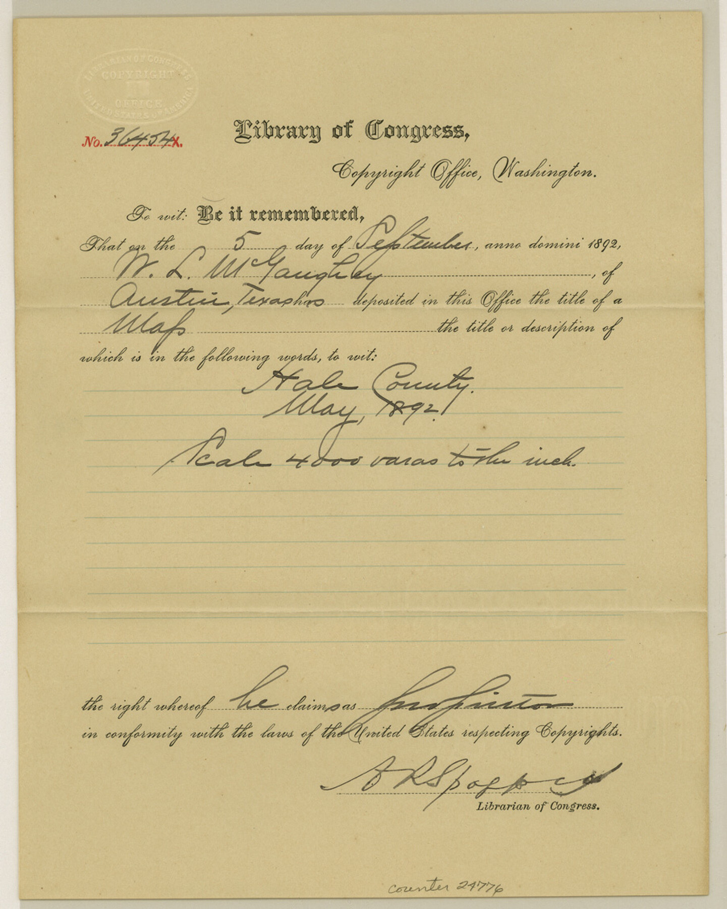
Hale County Sketch File 28
[Library of Congress Copyright certificate for GLO map of Hale County]
-
Map/Doc
24776
-
Collection
General Map Collection
-
Object Dates
1892/9/5 (Creation Date)
1892/11/23 (File Date)
1892 (Creation Date)
-
Counties
Hale
-
Subjects
Surveying Sketch File
-
Height x Width
11.3 x 9.0 inches
28.7 x 22.9 cm
-
Medium
paper, print with manuscript additions
-
Scale
1:4000
Part of: General Map Collection
Map of the River Sabine from Logan's Ferry to 32nd degree of North Latitude

Print $20.00
- Digital $50.00
Map of the River Sabine from Logan's Ferry to 32nd degree of North Latitude
Size 22.1 x 28.6 inches
Map/Doc 94002
Motley County Sketch File 6a (S)

Print $40.00
- Digital $50.00
Motley County Sketch File 6a (S)
1894
Size 14.3 x 14.4 inches
Map/Doc 32147
Houston County Working Sketch 34

Print $40.00
- Digital $50.00
Houston County Working Sketch 34
Size 50.9 x 37.3 inches
Map/Doc 66264
Fort Parker State Park

Print $20.00
- Digital $50.00
Fort Parker State Park
1950
Size 26.0 x 37.8 inches
Map/Doc 73569
Map of Coryell County

Print $20.00
- Digital $50.00
Map of Coryell County
1874
Size 22.4 x 26.8 inches
Map/Doc 3445
Flight Mission No. BRE-1P, Frame 117, Nueces County

Print $20.00
- Digital $50.00
Flight Mission No. BRE-1P, Frame 117, Nueces County
1956
Size 18.4 x 22.3 inches
Map/Doc 86683
Sterling County Sketch File 23

Print $10.00
- Digital $50.00
Sterling County Sketch File 23
1955
Size 11.2 x 8.8 inches
Map/Doc 37184
Harris County Working Sketch 66

Print $40.00
- Digital $50.00
Harris County Working Sketch 66
1955
Size 33.7 x 49.7 inches
Map/Doc 65958
Map of the Houston & Great Northern Railroad

Print $40.00
- Digital $50.00
Map of the Houston & Great Northern Railroad
1871
Size 26.6 x 48.4 inches
Map/Doc 64472
Wilbarger County Sketch File 11

Print $4.00
- Digital $50.00
Wilbarger County Sketch File 11
1885
Size 14.2 x 8.6 inches
Map/Doc 40183
Flight Mission No. BQR-9K, Frame 14, Brazoria County

Print $20.00
- Digital $50.00
Flight Mission No. BQR-9K, Frame 14, Brazoria County
1952
Size 18.7 x 22.3 inches
Map/Doc 84043
Presidio County Sketch File 31

Print $20.00
- Digital $50.00
Presidio County Sketch File 31
Size 11.4 x 20.8 inches
Map/Doc 11712
You may also like
Parker County Sketch File 22

Print $4.00
- Digital $50.00
Parker County Sketch File 22
Size 8.7 x 6.3 inches
Map/Doc 33562
[Additions Surrounding Fort Worth & Denver Railroad Fork]
![92840, [Additions Surrounding Fort Worth & Denver Railroad Fork], Twichell Survey Records](https://historictexasmaps.com/wmedia_w700/maps/92840-1.tif.jpg)
Print $20.00
- Digital $50.00
[Additions Surrounding Fort Worth & Denver Railroad Fork]
Size 32.2 x 32.1 inches
Map/Doc 92840
Flight Mission No. CUG-3P, Frame 132, Kleberg County

Print $20.00
- Digital $50.00
Flight Mission No. CUG-3P, Frame 132, Kleberg County
1956
Size 18.4 x 22.4 inches
Map/Doc 86267
Comal County Rolled Sketch 6

Print $4.00
- Digital $50.00
Comal County Rolled Sketch 6
1988
Size 25.0 x 19.1 inches
Map/Doc 5541
Isogonic Chart and Meridian Changes, University Land, Hudspeth County, Texas

Print $20.00
- Digital $50.00
Isogonic Chart and Meridian Changes, University Land, Hudspeth County, Texas
Size 28.5 x 34.1 inches
Map/Doc 62953
El Paso County Sketch File 1a

Print $4.00
- Digital $50.00
El Paso County Sketch File 1a
Size 12.1 x 8.2 inches
Map/Doc 21907
Victoria County Rolled Sketch 8

Print $20.00
- Digital $50.00
Victoria County Rolled Sketch 8
Size 34.2 x 27.5 inches
Map/Doc 8153
Flight Mission No. DAG-23K, Frame 169, Matagorda County

Print $20.00
- Digital $50.00
Flight Mission No. DAG-23K, Frame 169, Matagorda County
1953
Size 16.0 x 15.8 inches
Map/Doc 86507
Shelby County Working Sketch 31b

Print $40.00
- Digital $50.00
Shelby County Working Sketch 31b
2003
Size 34.0 x 70.9 inches
Map/Doc 78644
Pecos County Rolled Sketch 82

Print $20.00
- Digital $50.00
Pecos County Rolled Sketch 82
1930
Size 28.3 x 25.8 inches
Map/Doc 10191
Cooke County Working Sketch 35

Print $20.00
- Digital $50.00
Cooke County Working Sketch 35
1974
Size 30.7 x 32.6 inches
Map/Doc 68272
Reeves County Rolled Sketch 33

Print $20.00
- Digital $50.00
Reeves County Rolled Sketch 33
Size 24.2 x 36.5 inches
Map/Doc 7502