Sterling County Sketch File 23
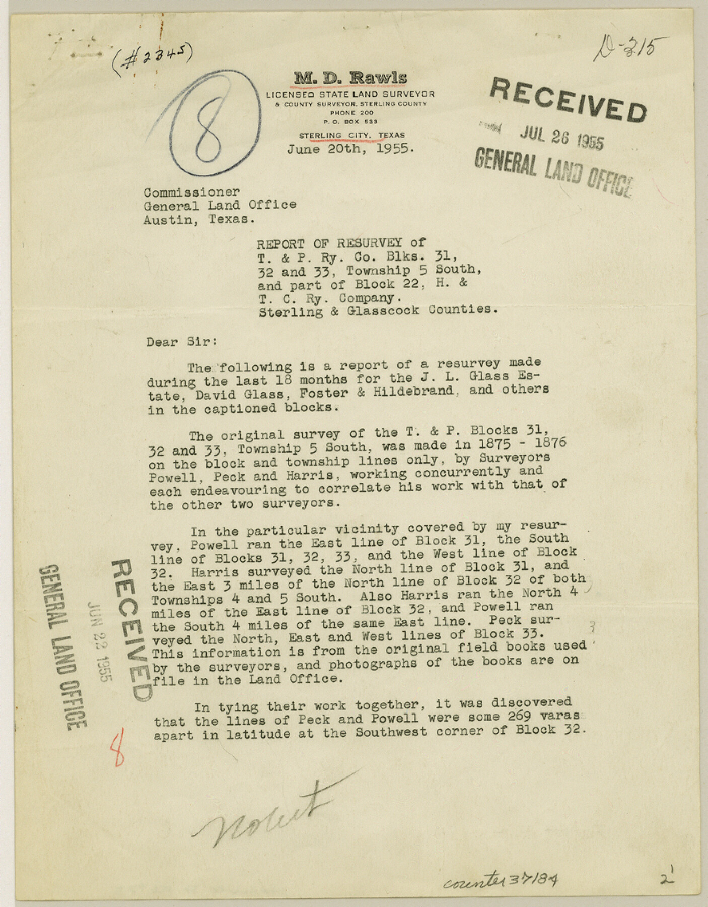
[Report of resurvey of T. & P. RR. Co. Blocks 31, 32, and 33, Township 5 South and part of Block 22, H. & T. C. RR. Co.]
-
Map/Doc
37184
-
Collection
General Map Collection
-
Object Dates
1955/6/20 (Creation Date)
1955/7/26 (File Date)
1955/6/20 (Correspondence Date)
1875 (Survey Date)
1876 (Survey Date)
-
People and Organizations
M.D. Rawls (Surveyor/Engineer)
Powell (Surveyor/Engineer)
Peck (Surveyor/Engineer)
Beckett (Surveyor/Engineer)
Kellis (Surveyor/Engineer)
H.L. George (Surveyor/Engineer)
-
Counties
Sterling
-
Subjects
Surveying Sketch File
-
Height x Width
11.2 x 8.8 inches
28.4 x 22.4 cm
-
Medium
paper, print
Part of: General Map Collection
Flight Mission No. BRA-9M, Frame 81, Jefferson County

Print $20.00
- Digital $50.00
Flight Mission No. BRA-9M, Frame 81, Jefferson County
1953
Size 18.3 x 22.6 inches
Map/Doc 85664
Bell County Sketch File 25a

Print $4.00
- Digital $50.00
Bell County Sketch File 25a
1880
Size 8.9 x 10.9 inches
Map/Doc 14424
Rusk County Working Sketch 27

Print $20.00
- Digital $50.00
Rusk County Working Sketch 27
1937
Size 35.6 x 29.3 inches
Map/Doc 63663
Lee County Working Sketch 14

Print $20.00
- Digital $50.00
Lee County Working Sketch 14
1981
Size 17.9 x 11.4 inches
Map/Doc 70393
Shelby County Rolled Sketch 21

Print $20.00
- Digital $50.00
Shelby County Rolled Sketch 21
Size 17.0 x 22.3 inches
Map/Doc 93285
Chambers County NRC Article 33.136 Sketch 11

Print $28.00
- Digital $50.00
Chambers County NRC Article 33.136 Sketch 11
2014
Size 24.0 x 36.0 inches
Map/Doc 94740
Dawson County Working Sketch 18

Print $40.00
- Digital $50.00
Dawson County Working Sketch 18
1963
Size 41.2 x 58.3 inches
Map/Doc 68562
Liberty County Sketch File B

Print $4.00
- Digital $50.00
Liberty County Sketch File B
1869
Size 12.0 x 8.2 inches
Map/Doc 30066
Reconnaissance of Aransas Pass, Texas

Print $20.00
- Digital $50.00
Reconnaissance of Aransas Pass, Texas
1852
Size 14.4 x 13.6 inches
Map/Doc 76171
Kaufman County Boundary File 6a

Print $6.00
- Digital $50.00
Kaufman County Boundary File 6a
Size 14.0 x 8.5 inches
Map/Doc 55963
Flight Mission No. DAG-24K, Frame 50, Matagorda County

Print $20.00
- Digital $50.00
Flight Mission No. DAG-24K, Frame 50, Matagorda County
1953
Size 16.0 x 16.0 inches
Map/Doc 86537
Map of Valley of Red River in Texas, Oklahoma, and Arkansas between Meridians 96 deg. 30 min. and 98 deg. West Longitude

Print $40.00
- Digital $50.00
Map of Valley of Red River in Texas, Oklahoma, and Arkansas between Meridians 96 deg. 30 min. and 98 deg. West Longitude
1920
Size 31.0 x 91.7 inches
Map/Doc 75252
You may also like
Map of the upper surveys in Robertson's Colony Sold by the State of Coahuila and Texas

Print $20.00
- Digital $50.00
Map of the upper surveys in Robertson's Colony Sold by the State of Coahuila and Texas
Size 26.8 x 22.0 inches
Map/Doc 82
Taylor County Rolled Sketch 29

Print $20.00
- Digital $50.00
Taylor County Rolled Sketch 29
Size 20.2 x 24.2 inches
Map/Doc 7922
Brewster County Rolled Sketch 148A

Print $20.00
- Digital $50.00
Brewster County Rolled Sketch 148A
1994
Size 28.0 x 36.3 inches
Map/Doc 5314
Working Sketch in Gray and Donley Counties

Print $20.00
- Digital $50.00
Working Sketch in Gray and Donley Counties
1910
Size 28.4 x 26.7 inches
Map/Doc 90707
McCulloch County

Print $40.00
- Digital $50.00
McCulloch County
1904
Size 50.0 x 37.3 inches
Map/Doc 7823
McLennan County Sketch File 35

Print $10.00
- Digital $50.00
McLennan County Sketch File 35
Size 13.1 x 8.1 inches
Map/Doc 31310
Edwards County Working Sketch 31

Print $20.00
- Digital $50.00
Edwards County Working Sketch 31
1947
Size 33.5 x 47.5 inches
Map/Doc 68907
Kendall County Boundary File 2b

Print $4.00
- Digital $50.00
Kendall County Boundary File 2b
Size 10.0 x 8.0 inches
Map/Doc 55754
Fayette County Boundary File 8

Print $19.00
- Digital $50.00
Fayette County Boundary File 8
Size 14.4 x 9.0 inches
Map/Doc 53402
Parker County Sketch File C

Print $4.00
- Digital $50.00
Parker County Sketch File C
1857
Size 6.1 x 7.8 inches
Map/Doc 33512
Blanco County Sketch File 44

Print $40.00
- Digital $50.00
Blanco County Sketch File 44
1902
Size 17.6 x 13.7 inches
Map/Doc 14669
Fort Bend County Working Sketch 13

Print $20.00
- Digital $50.00
Fort Bend County Working Sketch 13
1946
Size 29.0 x 29.3 inches
Map/Doc 69218