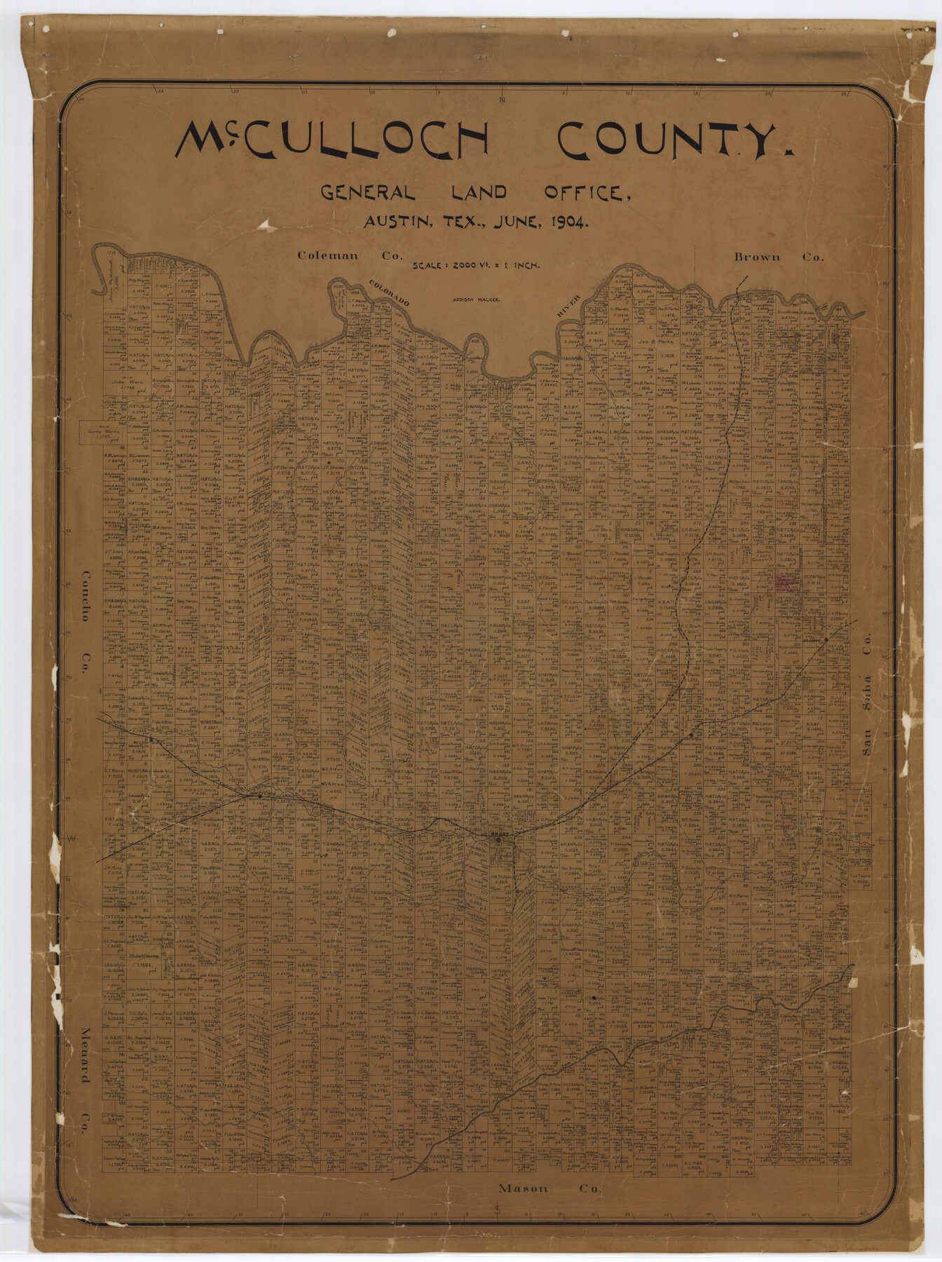
McCulloch County
-
Map/Doc
7823
-
Collection
General Map Collection
-
Object Dates
1904 (Creation Date)
-
People and Organizations
Texas General Land Office (Publisher)
Addison Walker (Compiler)
Addison Walker (Draftsman)
-
Counties
McCulloch
-
Subjects
County
-
Height x Width
50.0 x 37.3 inches
127.0 x 94.7 cm
-
Comments
Conservation funded in 2002 with donations from Bart Wulff and Abner G. Trigg, LSLS.
-
Features
Wolff Creek
Tiger Creek
Katemsy Creek
Camp Creek
San Saba River
Willow Creek
Cow Creek
South Brady Creek
Rio Santa Grande
Post Oak Creek
Brady
Brady Creek
Little Brady Creek
Onion Creek
Live Oak Creek
Bowie Creek
Colorado River
Dry Creek
Whiteland
Melvin
Satuit
Sellman
Saddle Creek
Cedar Creek
Bluff Creek
Elm Creek
Udoso Creek
Salt Creek
Deep Creek
FW&RG
GC&SF
Part of: General Map Collection
Cottle County Sketch File A and B

Print $27.00
- Digital $50.00
Cottle County Sketch File A and B
Size 18.4 x 24.1 inches
Map/Doc 11200
Flight Mission No. DQN-5K, Frame 73, Calhoun County

Print $20.00
- Digital $50.00
Flight Mission No. DQN-5K, Frame 73, Calhoun County
1953
Size 18.4 x 22.0 inches
Map/Doc 84406
Hutchinson County Sketch File 25

Print $6.00
- Digital $50.00
Hutchinson County Sketch File 25
1922
Size 11.2 x 8.8 inches
Map/Doc 27258
Hutchinson County Sketch File 19

Print $16.00
- Digital $50.00
Hutchinson County Sketch File 19
1913
Size 8.0 x 5.2 inches
Map/Doc 27234
The University of Texas at Austin

The University of Texas at Austin
Size 16.1 x 17.1 inches
Map/Doc 94387
Cottle County Working Sketch 10

Print $20.00
- Digital $50.00
Cottle County Working Sketch 10
1937
Size 18.1 x 15.6 inches
Map/Doc 68320
Runnels County Rolled Sketch A

Print $20.00
- Digital $50.00
Runnels County Rolled Sketch A
1891
Size 13.4 x 15.0 inches
Map/Doc 7539
Current Miscellaneous File 47

Print $12.00
- Digital $50.00
Current Miscellaneous File 47
1920
Size 16.3 x 9.2 inches
Map/Doc 73992
Coast Chart No. 212 - From Latitude 26° 33' to the Rio Grande, Texas

Print $20.00
- Digital $50.00
Coast Chart No. 212 - From Latitude 26° 33' to the Rio Grande, Texas
1886
Size 30.5 x 24.1 inches
Map/Doc 73504
D No. 4 - Reconnaissance of New River and Bar, North Carolina

Print $20.00
- Digital $50.00
D No. 4 - Reconnaissance of New River and Bar, North Carolina
1852
Size 19.4 x 15.7 inches
Map/Doc 97211

Webb County Sketch File 48

Print $20.00
- Digital $50.00
Webb County Sketch File 48
1939
Size 17.9 x 26.7 inches
Map/Doc 12646
You may also like
Howard County Working Sketch 8

Print $20.00
- Digital $50.00
Howard County Working Sketch 8
1956
Size 25.3 x 31.3 inches
Map/Doc 66275
Gaines County Sketch

Print $20.00
- Digital $50.00
Gaines County Sketch
1950
Size 13.6 x 18.7 inches
Map/Doc 92674
Wise County Sketch File 20

Print $14.00
- Digital $50.00
Wise County Sketch File 20
1860
Size 12.8 x 7.9 inches
Map/Doc 40557
Hamilton County Working Sketch 35

Print $20.00
- Digital $50.00
Hamilton County Working Sketch 35
Size 26.3 x 19.1 inches
Map/Doc 78286
United States - Gulf Coast - Padre I. and Laguna Madre Lat. 27° 12' to Lat. 26° 33' Texas

Print $20.00
- Digital $50.00
United States - Gulf Coast - Padre I. and Laguna Madre Lat. 27° 12' to Lat. 26° 33' Texas
1913
Size 27.0 x 18.3 inches
Map/Doc 72819
Denton County Sketch File 23

Print $5.00
- Digital $50.00
Denton County Sketch File 23
1862
Size 9.3 x 11.4 inches
Map/Doc 20748
Hardeman County Sketch File 32

Print $4.00
- Digital $50.00
Hardeman County Sketch File 32
Size 11.1 x 8.9 inches
Map/Doc 25068
Shelby County Sketch File 22

Print $6.00
- Digital $50.00
Shelby County Sketch File 22
Size 15.4 x 10.2 inches
Map/Doc 36643
Matagorda County Rolled Sketch 40

Print $20.00
- Digital $50.00
Matagorda County Rolled Sketch 40
Size 24.6 x 27.4 inches
Map/Doc 6704
Cass County Sketch File 9

Print $4.00
- Digital $50.00
Cass County Sketch File 9
1857
Size 8.0 x 13.1 inches
Map/Doc 17410
Current Miscellaneous File 94

Print $3.00
- Digital $50.00
Current Miscellaneous File 94
1851
Size 11.2 x 17.1 inches
Map/Doc 74268
Duval County Working Sketch 32

Print $20.00
- Digital $50.00
Duval County Working Sketch 32
1950
Size 18.8 x 18.0 inches
Map/Doc 68756