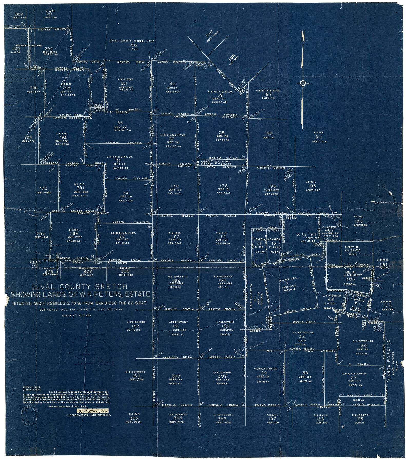
Duval County Rolled Sketch 25
Duval County sketch showing lands of W.R. Peters, Estate
-
Map/Doc
8813
-
Collection
General Map Collection
-
Object Dates
1/20/1944 (Creation Date)
3/1/1945 (File Date)
-
People and Organizations
C.A. Douglas (Surveyor/Engineer)
-
Counties
Duval
-
Subjects
Surveying Rolled Sketch
-
Height x Width
31.3 x 27.7 inches
79.5 x 70.4 cm
-
Medium
blueprint/diazo
-
Scale
1" = 600 varas
-
Comments
See Duval County Sketch File 66 (21444) for report.
Related maps
Duval County Sketch File 66

Print $12.00
- Digital $50.00
Duval County Sketch File 66
1944
Size 14.5 x 8.8 inches
Map/Doc 21444
Part of: General Map Collection
Trinity River, Levee Improvement Districts Widths of Floodways

Print $6.00
- Digital $50.00
Trinity River, Levee Improvement Districts Widths of Floodways
1920
Size 33.3 x 21.7 inches
Map/Doc 65251
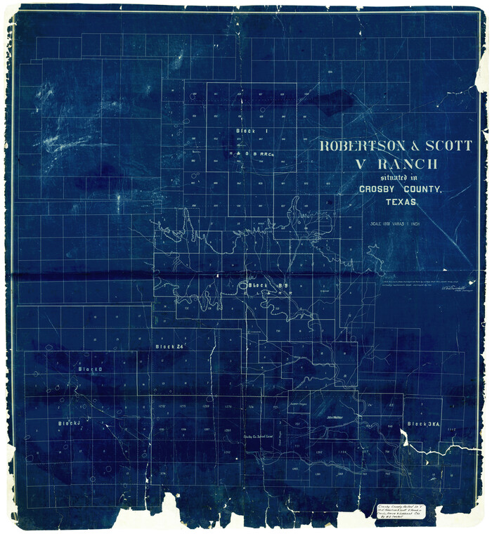
Crosby County Rolled Sketch V
Print $20.00
- Digital $50.00
Crosby County Rolled Sketch V
Size 45.4 x 41.8 inches
Map/Doc 8739
Baylor County Sketch File 12h

Print $49.00
- Digital $50.00
Baylor County Sketch File 12h
Size 9.3 x 14.7 inches
Map/Doc 14175
Jefferson County Working Sketch 14

Print $20.00
- Digital $50.00
Jefferson County Working Sketch 14
1948
Size 30.3 x 25.8 inches
Map/Doc 66557

Archer County Working Sketch Graphic Index

Print $20.00
- Digital $50.00
Archer County Working Sketch Graphic Index
1926
Size 46.7 x 39.4 inches
Map/Doc 76456
Hamilton County Working Sketch 35

Print $20.00
- Digital $50.00
Hamilton County Working Sketch 35
Size 26.3 x 19.1 inches
Map/Doc 78286
Goliad County Sketch File 15

Print $4.00
- Digital $50.00
Goliad County Sketch File 15
1879
Size 8.1 x 14.9 inches
Map/Doc 24245
Hutchinson County Working Sketch 12

Print $20.00
- Digital $50.00
Hutchinson County Working Sketch 12
1925
Size 20.6 x 29.9 inches
Map/Doc 66370
Lee County State Real Property Sketch 1

Print $20.00
- Digital $50.00
Lee County State Real Property Sketch 1
2010
Size 24.3 x 35.9 inches
Map/Doc 89286
Nolan County Working Sketch 11

Print $40.00
- Digital $50.00
Nolan County Working Sketch 11
1971
Size 67.1 x 37.8 inches
Map/Doc 71302
Flight Mission No. DQN-1K, Frame 151, Calhoun County

Print $20.00
- Digital $50.00
Flight Mission No. DQN-1K, Frame 151, Calhoun County
1953
Size 18.6 x 22.3 inches
Map/Doc 84210
You may also like
Aransas County Working Sketch 17

Print $20.00
- Digital $50.00
Aransas County Working Sketch 17
1965
Size 27.2 x 21.1 inches
Map/Doc 67184
Oldham County Sketch File 20

Print $6.00
- Digital $50.00
Oldham County Sketch File 20
1916
Size 11.1 x 8.5 inches
Map/Doc 33275
Comanche County Sketch File 22b

Print $40.00
- Digital $50.00
Comanche County Sketch File 22b
1872
Size 12.1 x 14.8 inches
Map/Doc 19109
Hemphill County Sketch File 4

Print $14.00
- Digital $50.00
Hemphill County Sketch File 4
1903
Size 14.1 x 8.7 inches
Map/Doc 26288

Flight Mission No. DAG-26K, Frame 58, Matagorda County

Print $20.00
- Digital $50.00
Flight Mission No. DAG-26K, Frame 58, Matagorda County
1953
Size 18.5 x 16.1 inches
Map/Doc 86578
[North part of G. C. & S. F. Block OP, Runnels County School Land and Blks. AB, CD and GH]
![90310, [North part of G. C. & S. F. Block OP, Runnels County School Land and Blks. AB, CD and GH], Twichell Survey Records](https://historictexasmaps.com/wmedia_w700/maps/90310-1.tif.jpg)
Print $20.00
- Digital $50.00
[North part of G. C. & S. F. Block OP, Runnels County School Land and Blks. AB, CD and GH]
Size 17.5 x 22.4 inches
Map/Doc 90310
Jefferson County Sketch File 34

Print $9.00
- Digital $50.00
Jefferson County Sketch File 34
1900
Size 10.9 x 7.1 inches
Map/Doc 28203

Morris County Rolled Sketch 2A

Print $20.00
- Digital $50.00
Morris County Rolled Sketch 2A
Size 24.2 x 19.1 inches
Map/Doc 10249
D. B. Gardner vs. Mrs. Clara C. Starr

Print $20.00
- Digital $50.00
D. B. Gardner vs. Mrs. Clara C. Starr
Size 16.7 x 28.8 inches
Map/Doc 92149
Dickens County Sketch File 23

Print $6.00
- Digital $50.00
Dickens County Sketch File 23
1914
Size 12.4 x 8.4 inches
Map/Doc 20990