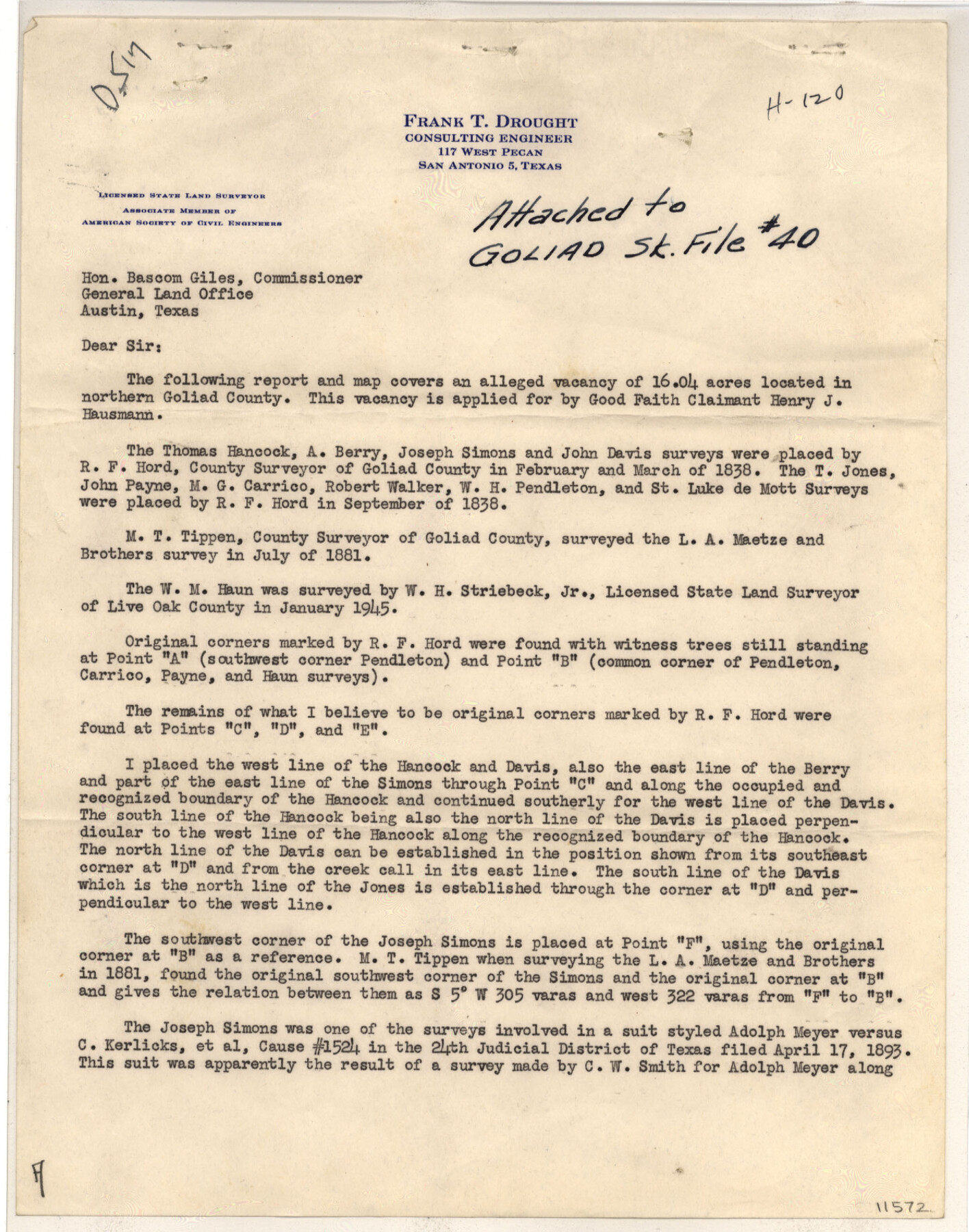
Goliad County Sketch File 40
Area in Northern Goliad County
-
Map/Doc
11572
-
Collection
General Map Collection
-
Object Dates
1949/5/28 (Creation Date)
1949/6/23 (File Date)
1838 (Survey Date)
1838 (Survey Date)
1881 (Survey Date)
1945 (Survey Date)
1938/3/24 (Survey Date)
-
People and Organizations
Frank T. Drought (Surveyor/Engineer)
R.F. Hord (Surveyor/Engineer)
M.T. Tippen (Surveyor/Engineer)
W.H. Streibeck, Jr. (Surveyor/Engineer)
-
Counties
Goliad
-
Subjects
Surveying Sketch File
-
Height x Width
23.9 x 36.0 inches
60.7 x 91.4 cm
-
Medium
multi-page, multi-format
-
Scale
1:500
-
Features
Coleto Creek
Part of: General Map Collection
Briscoe County Working Sketch 8

Print $20.00
- Digital $50.00
Briscoe County Working Sketch 8
1947
Size 13.2 x 15.8 inches
Map/Doc 67811
Map of Cass County

Print $20.00
- Digital $50.00
Map of Cass County
1847
Size 21.3 x 18.4 inches
Map/Doc 3368
Tom Green County Sketch File 13

Print $4.00
- Digital $50.00
Tom Green County Sketch File 13
Size 6.3 x 8.4 inches
Map/Doc 38170
Sabine County Sketch File 1

Print $2.00
Sabine County Sketch File 1
Size 14.2 x 7.7 inches
Map/Doc 35601
PSL Field Notes for Block C41 in Dawson, Lynn, and Terry Counties, Block C42 in Lynn and Terry Counties, and Blocks C40 and D23 in Lynn County

PSL Field Notes for Block C41 in Dawson, Lynn, and Terry Counties, Block C42 in Lynn and Terry Counties, and Blocks C40 and D23 in Lynn County
Map/Doc 81668
Galveston County NRC Article 33.136 Sketch 45

Print $21.00
- Digital $50.00
Galveston County NRC Article 33.136 Sketch 45
2007
Size 18.7 x 23.4 inches
Map/Doc 87365
Potter County Rolled Sketch 6

Print $20.00
- Digital $50.00
Potter County Rolled Sketch 6
Size 26.3 x 35.0 inches
Map/Doc 7320
Rusk County Working Sketch 23

Print $20.00
- Digital $50.00
Rusk County Working Sketch 23
1949
Size 23.9 x 26.5 inches
Map/Doc 63659
Maps of Gulf Intracoastal Waterway, Texas - Sabine River to the Rio Grande and connecting waterways including ship channels

Print $20.00
- Digital $50.00
Maps of Gulf Intracoastal Waterway, Texas - Sabine River to the Rio Grande and connecting waterways including ship channels
1966
Size 14.6 x 22.2 inches
Map/Doc 61939
Crosby County Working Sketch 9

Print $20.00
- Digital $50.00
Crosby County Working Sketch 9
1943
Size 19.8 x 35.2 inches
Map/Doc 68443
Sterling County Working Sketch 3

Print $40.00
- Digital $50.00
Sterling County Working Sketch 3
1948
Size 43.6 x 55.2 inches
Map/Doc 63985
Clay County Rolled Sketch 4

Print $20.00
- Digital $50.00
Clay County Rolled Sketch 4
1949
Size 32.2 x 25.6 inches
Map/Doc 5486
You may also like

Gulf Coast of the United States, Key West to Rio Grande

Print $20.00
- Digital $50.00
Gulf Coast of the United States, Key West to Rio Grande
1863
Size 27.5 x 18.3 inches
Map/Doc 72664
[Beaumont, Sour Lake and Western Ry. Right of Way and Alignment - Frisco]
![64126, [Beaumont, Sour Lake and Western Ry. Right of Way and Alignment - Frisco], General Map Collection](https://historictexasmaps.com/wmedia_w700/maps/64126.tif.jpg)
Print $20.00
- Digital $50.00
[Beaumont, Sour Lake and Western Ry. Right of Way and Alignment - Frisco]
1910
Size 20.1 x 46.1 inches
Map/Doc 64126
McMullen County

Print $40.00
- Digital $50.00
McMullen County
1967
Size 50.8 x 35.8 inches
Map/Doc 95586
Working Sketch in Wichita County

Print $20.00
- Digital $50.00
Working Sketch in Wichita County
1919
Size 14.1 x 27.0 inches
Map/Doc 91993
[Sketch N, showing Blocks 5-7, 13, 48-51, and C1-7]
![91771, [Sketch N, showing Blocks 5-7, 13, 48-51, and C1-7], Twichell Survey Records](https://historictexasmaps.com/wmedia_w700/maps/91771-1.tif.jpg)
Print $20.00
- Digital $50.00
[Sketch N, showing Blocks 5-7, 13, 48-51, and C1-7]
Size 32.1 x 25.9 inches
Map/Doc 91771
McMullen County Sketch File 19

Print $4.00
- Digital $50.00
McMullen County Sketch File 19
Size 12.8 x 8.1 inches
Map/Doc 31371
Edwards County Working Sketch 122

Print $20.00
- Digital $50.00
Edwards County Working Sketch 122
1976
Size 25.8 x 33.9 inches
Map/Doc 68998
Ector County Working Sketch 33

Print $20.00
- Digital $50.00
Ector County Working Sketch 33
1982
Size 24.7 x 29.0 inches
Map/Doc 68876
Revised Sectional Map No. 4 Showing Land Surveys in the Western Portion of the County of El Paso, Texas

Print $20.00
- Digital $50.00
Revised Sectional Map No. 4 Showing Land Surveys in the Western Portion of the County of El Paso, Texas
Size 24.7 x 19.7 inches
Map/Doc 93226

Map of a Route from Austin-City to Paso del Norte & c.

Print $20.00
- Digital $50.00
Map of a Route from Austin-City to Paso del Norte & c.
1849
Size 11.7 x 30.5 inches
Map/Doc 2121