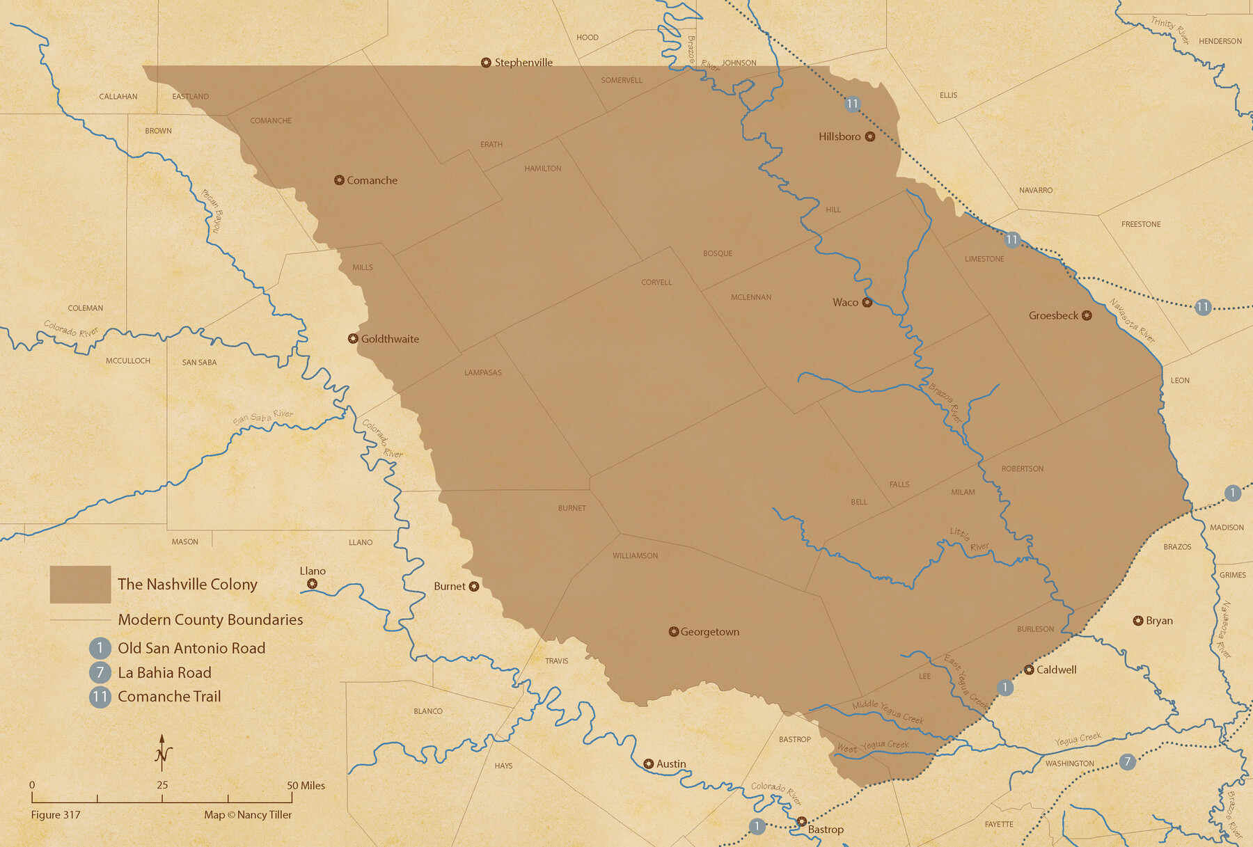
The Nashville Association/Company Empresario Colony. October 15, 1827
Figure No. 317 from 'A Boundary Atlas of Texas, 1821-1845' by Jim Tiller
-
Map/Doc
96001
-
Collection
Nancy and Jim Tiller Digital Collection
-
Object Dates
2020/1/1 (Creation Date)
-
People and Organizations
Jim Tiller (Author)
Nancy Tiller (Cartographer)
Gang Gong (GIS Professional)
-
Subjects
Atlas Colony Mexican Texas Texas Boundaries
-
Height x Width
14.7 x 21.7 inches
37.3 x 55.1 cm
-
Medium
digital image
-
Comments
To purchase a digital PDF copy of "A Boundary Atlas of Texas, 1821-1845" see 96437.
Part of: Nancy and Jim Tiller Digital Collection
From Citizens of Victoria County to Redefine the Boundary Between Jackson and Victoria Counties, November 25, 1841

Print $20.00
From Citizens of Victoria County to Redefine the Boundary Between Jackson and Victoria Counties, November 25, 1841
2020
Size 23.3 x 21.7 inches
Map/Doc 96394
The Republic County of Robertson. November 28, 1839

Print $20.00
The Republic County of Robertson. November 28, 1839
2020
Size 18.9 x 21.6 inches
Map/Doc 96260
Thorn Empresario Colony. April 25, 1825

Print $20.00
Thorn Empresario Colony. April 25, 1825
2020
Size 17.0 x 21.7 inches
Map/Doc 96006
The Land Offices. No. 4, Nacogdoches, December 22, 1836

Print $20.00
The Land Offices. No. 4, Nacogdoches, December 22, 1836
2020
Size 14.8 x 21.7 inches
Map/Doc 96417
The Mexican Municipality of San Augustine. Created March 6, 1834

Print $20.00
The Mexican Municipality of San Augustine. Created March 6, 1834
2020
Size 24.1 x 21.7 inches
Map/Doc 96032
The Mexican Department of Brazos. Created, March 18, 1834

Print $20.00
The Mexican Department of Brazos. Created, March 18, 1834
2020
Size 19.7 x 21.7 inches
Map/Doc 95975
The Mexican Municipality of Gonzales. Proposed, No Date

Print $20.00
The Mexican Municipality of Gonzales. Proposed, No Date
2020
Size 20.4 x 21.7 inches
Map/Doc 96020
The Republic County of Harris. January 21, 1841

Print $20.00
The Republic County of Harris. January 21, 1841
2020
Size 17.7 x 21.7 inches
Map/Doc 96166
The Republic County of Jackson. January 19, 1841

Print $20.00
The Republic County of Jackson. January 19, 1841
2020
Size 15.6 x 21.8 inches
Map/Doc 96188
The Peters Colony. January 29, 1844

Print $20.00
The Peters Colony. January 29, 1844
2020
Size 17.2 x 21.7 inches
Map/Doc 96366
The Republic County of Harris. May 15, 1838

Print $20.00
The Republic County of Harris. May 15, 1838
2020
Size 17.7 x 21.7 inches
Map/Doc 96163
The Republic County of Rusk. December 29, 1845

Print $20.00
The Republic County of Rusk. December 29, 1845
2020
Size 19.1 x 21.7 inches
Map/Doc 96268
You may also like
Jackson County Working Sketch 14

Print $20.00
- Digital $50.00
Jackson County Working Sketch 14
1990
Size 31.7 x 32.2 inches
Map/Doc 66462
Starr County Rolled Sketch 2

Print $40.00
- Digital $50.00
Starr County Rolled Sketch 2
1853
Size 31.7 x 48.5 inches
Map/Doc 9938
Llano County Boundary File 2

Print $30.00
- Digital $50.00
Llano County Boundary File 2
Size 14.3 x 8.8 inches
Map/Doc 56443
Madison County Working Sketch 7

Print $20.00
- Digital $50.00
Madison County Working Sketch 7
1982
Size 12.7 x 17.4 inches
Map/Doc 70769
Dallas County Sketch File 26

Print $20.00
- Digital $50.00
Dallas County Sketch File 26
1942
Size 24.9 x 18.9 inches
Map/Doc 11289
Burleson County Working Sketch 24

Print $20.00
- Digital $50.00
Burleson County Working Sketch 24
1980
Size 18.5 x 35.9 inches
Map/Doc 67743
Bell County Sketch File 10

Print $4.00
- Digital $50.00
Bell County Sketch File 10
1851
Size 12.7 x 8.4 inches
Map/Doc 14381
Flight Mission No. DQO-6K, Frame 22, Galveston County

Print $20.00
- Digital $50.00
Flight Mission No. DQO-6K, Frame 22, Galveston County
1952
Size 18.8 x 22.4 inches
Map/Doc 85095
Flight Mission No. CRC-2R, Frame 184, Chambers County

Print $20.00
- Digital $50.00
Flight Mission No. CRC-2R, Frame 184, Chambers County
1956
Size 18.6 x 22.2 inches
Map/Doc 84762
City of Lamesa, Texas

Print $40.00
- Digital $50.00
City of Lamesa, Texas
Size 52.2 x 43.2 inches
Map/Doc 89855
Amistad International Reservoir on Rio Grande 96

Print $20.00
- Digital $50.00
Amistad International Reservoir on Rio Grande 96
1950
Size 28.5 x 41.0 inches
Map/Doc 75527
Reagan County Working Sketch 28

Print $40.00
- Digital $50.00
Reagan County Working Sketch 28
1963
Size 55.7 x 42.4 inches
Map/Doc 71870