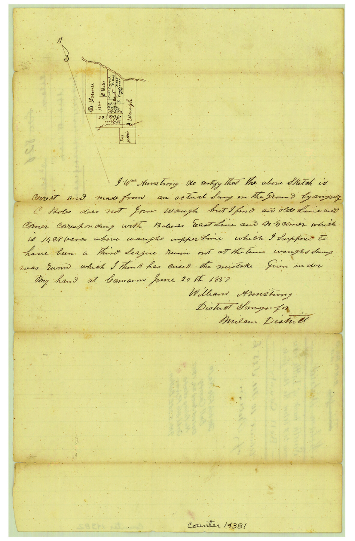
Bell County Sketch File 10
[Sketch on south bank of Little River southeast of Belton]
-
Map/Doc
14381
-
Collection
General Map Collection
-
Object Dates
1851/6/20 (Creation Date)
1858 (File Date)
-
People and Organizations
William Armstrong (Surveyor/Engineer)
-
Counties
Bell
-
Subjects
Surveying Sketch File
-
Height x Width
12.7 x 8.4 inches
32.3 x 21.3 cm
-
Medium
paper, manuscript
Part of: General Map Collection

Harris County Rolled Sketch 71

Print $20.00
- Digital $50.00
Harris County Rolled Sketch 71
1944
Size 19.3 x 26.7 inches
Map/Doc 6111
Trinity County Sketch File 31

Print $40.00
- Digital $50.00
Trinity County Sketch File 31
Size 14.1 x 13.4 inches
Map/Doc 38570
Reagan County Rolled Sketch 6

Print $20.00
- Digital $50.00
Reagan County Rolled Sketch 6
Size 17.8 x 17.3 inches
Map/Doc 7435
Erath County Working Sketch 21

Print $20.00
- Digital $50.00
Erath County Working Sketch 21
1965
Size 23.9 x 19.8 inches
Map/Doc 69102
Bowie County Working Sketch Graphic Index

Print $20.00
- Digital $50.00
Bowie County Working Sketch Graphic Index
1933
Size 38.9 x 47.1 inches
Map/Doc 76470
Mason County Sketch File 2

Print $22.00
- Digital $50.00
Mason County Sketch File 2
1847
Size 8.0 x 14.2 inches
Map/Doc 30680
Jeff Davis County Sketch File 26 1/2

Print $10.00
- Digital $50.00
Jeff Davis County Sketch File 26 1/2
Size 9.0 x 10.4 inches
Map/Doc 27999
Bastrop County Sketch File 5

Print $4.00
- Digital $50.00
Bastrop County Sketch File 5
Size 8.1 x 10.2 inches
Map/Doc 14048
McCulloch County Sketch File 4

Print $4.00
- Digital $50.00
McCulloch County Sketch File 4
1883
Size 11.1 x 8.5 inches
Map/Doc 31175
Flight Mission No. CGI-1N, Frame 219, Cameron County

Print $20.00
- Digital $50.00
Flight Mission No. CGI-1N, Frame 219, Cameron County
1955
Size 18.6 x 22.2 inches
Map/Doc 84528
Brewster County Rolled Sketch 63

Print $40.00
- Digital $50.00
Brewster County Rolled Sketch 63
1939
Size 77.1 x 43.6 inches
Map/Doc 8488
You may also like
Red River County Sketch File 8b

Print $6.00
- Digital $50.00
Red River County Sketch File 8b
1860
Size 8.2 x 3.7 inches
Map/Doc 35114
The Republic County of Victoria. Proposed, Late Fall 1837

Print $20.00
The Republic County of Victoria. Proposed, Late Fall 1837
2020
Size 22.5 x 21.7 inches
Map/Doc 96294
Edwards County Rolled Sketch 34

Print $20.00
- Digital $50.00
Edwards County Rolled Sketch 34
1994
Size 18.0 x 33.5 inches
Map/Doc 5816
Wilbarger Co.

Print $20.00
- Digital $50.00
Wilbarger Co.
1949
Size 47.8 x 38.8 inches
Map/Doc 73324
Township 10 North Range 15 West, North Western District, Louisiana

Print $20.00
- Digital $50.00
Township 10 North Range 15 West, North Western District, Louisiana
1854
Size 19.5 x 24.6 inches
Map/Doc 65871

Webb County Rolled Sketch 46

Print $20.00
- Digital $50.00
Webb County Rolled Sketch 46
1942
Size 25.8 x 27.6 inches
Map/Doc 8202
Working Sketch in Bailey County

Print $20.00
- Digital $50.00
Working Sketch in Bailey County
1906
Size 22.2 x 12.5 inches
Map/Doc 90184
Gray County Sketch File B1

Print $26.00
- Digital $50.00
Gray County Sketch File B1
1882
Size 8.9 x 8.6 inches
Map/Doc 24398
Runnels County Sketch File 8

Print $40.00
Runnels County Sketch File 8
Size 37.9 x 37.5 inches
Map/Doc 10591
Working Sketch No. IV in Pecos County

Print $20.00
- Digital $50.00
Working Sketch No. IV in Pecos County
1886
Size 36.7 x 23.6 inches
Map/Doc 3954
Hill County Sketch File 3

Print $2.00
- Digital $50.00
Hill County Sketch File 3
Size 8.3 x 10.4 inches
Map/Doc 26463