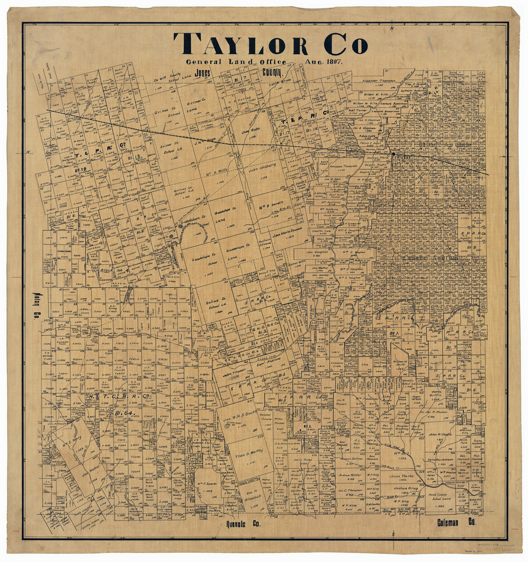
Taylor Co.
-
Map/Doc
63059
-
Collection
General Map Collection
-
Object Dates
8/1897 (Creation Date)
-
Counties
Taylor
-
Subjects
County
-
Height x Width
37.1 x 35.0 inches
94.2 x 88.9 cm
Part of: General Map Collection
Travis County Working Sketch 28

Print $20.00
- Digital $50.00
Travis County Working Sketch 28
1955
Size 31.5 x 30.7 inches
Map/Doc 69412
Dickens County Boundary File 3

Print $28.00
- Digital $50.00
Dickens County Boundary File 3
Size 14.1 x 8.8 inches
Map/Doc 52541
No. 3 Chart of Channel connecting Corpus Christi Bay with Aransas Bay, Texas

Print $20.00
- Digital $50.00
No. 3 Chart of Channel connecting Corpus Christi Bay with Aransas Bay, Texas
1878
Size 18.2 x 28.0 inches
Map/Doc 72772
Donley County Sketch File B8

Print $20.00
- Digital $50.00
Donley County Sketch File B8
1920
Size 15.3 x 15.9 inches
Map/Doc 11378
Bowie County Sketch File 6c

Print $40.00
- Digital $50.00
Bowie County Sketch File 6c
1927
Size 20.1 x 16.1 inches
Map/Doc 10942
Uvalde County Working Sketch 43

Print $20.00
- Digital $50.00
Uvalde County Working Sketch 43
1978
Size 29.3 x 27.7 inches
Map/Doc 72113
USGS Topographic: Texas-Oklahoma Denison Quadrangle

Print $20.00
- Digital $50.00
USGS Topographic: Texas-Oklahoma Denison Quadrangle
1901
Size 21.3 x 17.4 inches
Map/Doc 75108
Howard County Boundary File 4b

Print $24.00
- Digital $50.00
Howard County Boundary File 4b
Size 11.3 x 8.9 inches
Map/Doc 55168
Cameron County Sketch File 16

Print $18.00
- Digital $50.00
Cameron County Sketch File 16
1998
Size 11.2 x 8.6 inches
Map/Doc 76334
Map of Padre Island Showing Location of Zoning Districts

Print $20.00
- Digital $50.00
Map of Padre Island Showing Location of Zoning Districts
1971
Size 18.5 x 26.4 inches
Map/Doc 4812
Anderson County Sketch File 11a

Print $6.00
- Digital $50.00
Anderson County Sketch File 11a
1854
Size 8.2 x 8.2 inches
Map/Doc 12768
Right of Way & Track Map, St. Louis, Brownsville & Mexico Ry. operated by St. Louis, Brownsville & Mexico Ry. Co.

Print $40.00
- Digital $50.00
Right of Way & Track Map, St. Louis, Brownsville & Mexico Ry. operated by St. Louis, Brownsville & Mexico Ry. Co.
1919
Size 25.2 x 57.1 inches
Map/Doc 64613
You may also like
Minnesota Route the shortest and best to the Idaho Gold Mines

Print $20.00
- Digital $50.00
Minnesota Route the shortest and best to the Idaho Gold Mines
Size 21.0 x 46.3 inches
Map/Doc 93989
Ellis County Sketch File 11

Print $40.00
- Digital $50.00
Ellis County Sketch File 11
1860
Size 12.6 x 16.2 inches
Map/Doc 21847
Gonzales County

Print $40.00
- Digital $50.00
Gonzales County
1986
Size 41.6 x 54.7 inches
Map/Doc 73160
Trip to the West and Texas Comprising a Journey of Eight Thousand Miles, Through New-York, Michigan, Illinois, Missouri, Louisiana and Texas, in the Autumn and Winter of 1834-5. Interspersed with Anecdotes, Incidents and Observations. With a Brief Sketch

Trip to the West and Texas Comprising a Journey of Eight Thousand Miles, Through New-York, Michigan, Illinois, Missouri, Louisiana and Texas, in the Autumn and Winter of 1834-5. Interspersed with Anecdotes, Incidents and Observations. With a Brief Sketch
1836
Map/Doc 97078
J. B. Chilton's Subdivision of League 289, Gaines County, Texas

Print $20.00
- Digital $50.00
J. B. Chilton's Subdivision of League 289, Gaines County, Texas
1924
Size 18.7 x 24.7 inches
Map/Doc 92682
Jefferson County Rolled Sketch 44

Print $20.00
- Digital $50.00
Jefferson County Rolled Sketch 44
1957
Size 26.9 x 25.5 inches
Map/Doc 6401
Knox County Rolled Sketch 8

Print $20.00
- Digital $50.00
Knox County Rolled Sketch 8
Size 28.2 x 32.5 inches
Map/Doc 9406
Coast Chart No. 210 Aransas Pass and Corpus Christi Bay with the coast to latitude 27° 12' Texas

Print $20.00
- Digital $50.00
Coast Chart No. 210 Aransas Pass and Corpus Christi Bay with the coast to latitude 27° 12' Texas
1887
Size 26.7 x 18.3 inches
Map/Doc 72810
Brewster County Sketch File 16

Print $46.00
- Digital $50.00
Brewster County Sketch File 16
1936
Size 14.3 x 8.6 inches
Map/Doc 15777
Right of Way and Track Map, The Wichita Falls & Southern Railway

Print $40.00
- Digital $50.00
Right of Way and Track Map, The Wichita Falls & Southern Railway
1942
Size 25.5 x 92.5 inches
Map/Doc 64513

Aransas County Sketch File 16

Print $40.00
- Digital $50.00
Aransas County Sketch File 16
1877
Size 16.4 x 12.8 inches
Map/Doc 13147