Bowie County Sketch File 6c
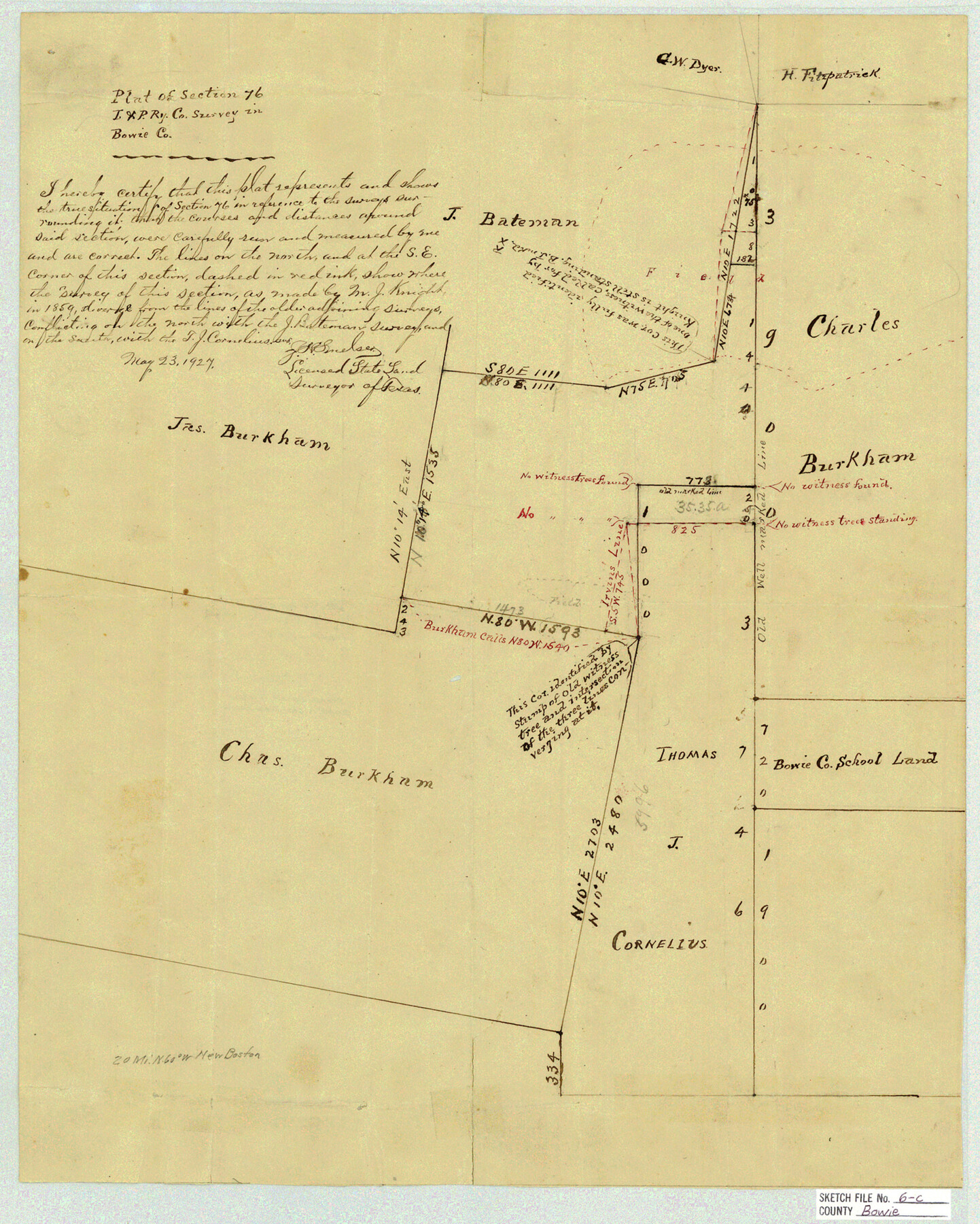
Plat of section 76, T. & P. Ry. Co. survey in Bowie Co.
-
Map/Doc
10942
-
Collection
General Map Collection
-
Object Dates
1927/5/23 (Creation Date)
1927/10/3 (File Date)
-
People and Organizations
J.H. Smelser (Surveyor/Engineer)
-
Counties
Bowie
-
Subjects
Surveying Sketch File
-
Height x Width
20.1 x 16.1 inches
51.1 x 40.9 cm
-
Medium
paper, manuscript
Part of: General Map Collection
Borden County Working Sketch 15

Print $20.00
- Digital $50.00
Borden County Working Sketch 15
1984
Size 25.5 x 18.9 inches
Map/Doc 67475
Orange County Working Sketch 15

Print $20.00
- Digital $50.00
Orange County Working Sketch 15
1928
Size 19.3 x 24.6 inches
Map/Doc 71347
Medina County Working Sketch 4

Print $40.00
- Digital $50.00
Medina County Working Sketch 4
1945
Size 52.6 x 35.5 inches
Map/Doc 70919
Chambers County Sketch File 36

Print $11.00
- Digital $50.00
Chambers County Sketch File 36
1935
Size 15.6 x 9.1 inches
Map/Doc 17647
Stephens County Sketch File B

Print $9.00
- Digital $50.00
Stephens County Sketch File B
1919
Size 13.2 x 8.7 inches
Map/Doc 37070
Flight Mission No. DCL-6C, Frame 66, Kenedy County

Print $20.00
- Digital $50.00
Flight Mission No. DCL-6C, Frame 66, Kenedy County
1943
Size 18.7 x 22.4 inches
Map/Doc 85908
Uvalde County Sketch File 12A

Print $20.00
- Digital $50.00
Uvalde County Sketch File 12A
1887
Size 19.2 x 30.0 inches
Map/Doc 12527
Johnson County Rolled Sketch B

Print $20.00
- Digital $50.00
Johnson County Rolled Sketch B
1891
Size 28.2 x 38.9 inches
Map/Doc 6449
Hill County Sketch File 4

Print $8.00
- Digital $50.00
Hill County Sketch File 4
1859
Size 14.1 x 8.0 inches
Map/Doc 26464
Fisher County Working Sketch 13

Print $20.00
- Digital $50.00
Fisher County Working Sketch 13
1956
Size 29.8 x 32.7 inches
Map/Doc 69147
Kimble County Sketch File C

Print $4.00
- Digital $50.00
Kimble County Sketch File C
Size 14.9 x 7.5 inches
Map/Doc 28965
Dawson County Sketch File 31

Print $4.00
- Digital $50.00
Dawson County Sketch File 31
1989
Size 11.4 x 9.0 inches
Map/Doc 20614
You may also like
Hale County Working Sketch Graphic Index

Print $20.00
- Digital $50.00
Hale County Working Sketch Graphic Index
1931
Size 46.4 x 36.9 inches
Map/Doc 76562
Webb County Rolled Sketch 3

Print $20.00
- Digital $50.00
Webb County Rolled Sketch 3
1884
Size 19.7 x 24.8 inches
Map/Doc 8170
Sutton County Sketch File 26

Print $20.00
- Digital $50.00
Sutton County Sketch File 26
1929
Size 19.6 x 14.8 inches
Map/Doc 12383
Presidio County Rolled Sketch 131A

Print $40.00
- Digital $50.00
Presidio County Rolled Sketch 131A
1991
Size 37.6 x 49.7 inches
Map/Doc 10713
Cottle County

Print $20.00
- Digital $50.00
Cottle County
1971
Size 41.5 x 33.3 inches
Map/Doc 77250
Flight Mission No. CGI-3N, Frame 48, Cameron County

Print $20.00
- Digital $50.00
Flight Mission No. CGI-3N, Frame 48, Cameron County
1954
Size 18.7 x 22.2 inches
Map/Doc 84554
Subdivision of Mallet Land and Cattle Company's Ranch Hockley, Cochran, Terry, and Yoakum Counties, Texas

Print $20.00
- Digital $50.00
Subdivision of Mallet Land and Cattle Company's Ranch Hockley, Cochran, Terry, and Yoakum Counties, Texas
Size 17.3 x 16.4 inches
Map/Doc 92207
Glasscock County Working Sketch 1

Print $20.00
- Digital $50.00
Glasscock County Working Sketch 1
Size 26.6 x 43.0 inches
Map/Doc 63174
Henderson County Rolled Sketch 11

Print $20.00
- Digital $50.00
Henderson County Rolled Sketch 11
1915
Size 29.4 x 42.5 inches
Map/Doc 75946
Live Oak County Working Sketch 21

Print $20.00
- Digital $50.00
Live Oak County Working Sketch 21
1964
Size 30.8 x 33.9 inches
Map/Doc 70606
Childress County School Land Situated in Bailey and Cochran Counties

Print $20.00
- Digital $50.00
Childress County School Land Situated in Bailey and Cochran Counties
Size 21.8 x 25.4 inches
Map/Doc 92499
[Surveys along the Leona and Frio Rivers]
![16, [Surveys along the Leona and Frio Rivers], General Map Collection](https://historictexasmaps.com/wmedia_w700/maps/16.tif.jpg)
Print $20.00
- Digital $50.00
[Surveys along the Leona and Frio Rivers]
1841
Size 12.4 x 13.1 inches
Map/Doc 16