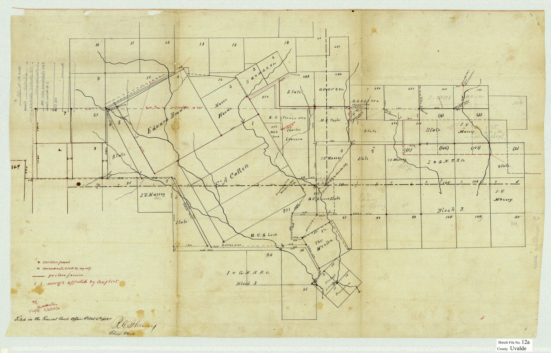
Uvalde County Sketch File 12A
[Sketch of lands in the southwest corner of the county and extending into adjacent counties]
-
Map/Doc
12527
-
Collection
General Map Collection
-
Object Dates
9/26/1887 (Creation Date)
10/6/1887 (File Date)
-
People and Organizations
O.H. Hector (Surveyor/Engineer)
-
Counties
Uvalde Zavala Maverick Kinney
-
Subjects
Surveying Sketch File
-
Height x Width
19.2 x 30.0 inches
48.8 x 76.2 cm
-
Medium
paper, manuscript
-
Comments
See Uvalde County Sketch File 12 (38977) for field notes and office sketch.
Related maps
Uvalde County Sketch File 12

Print $18.00
- Digital $50.00
Uvalde County Sketch File 12
1887
Size 9.3 x 17.0 inches
Map/Doc 38977
Part of: General Map Collection
Chambers County Rolled Sketch CL

Print $40.00
- Digital $50.00
Chambers County Rolled Sketch CL
1909
Size 56.2 x 21.0 inches
Map/Doc 8610
Burnet County Sketch File 39

Print $40.00
- Digital $50.00
Burnet County Sketch File 39
Size 9.6 x 24.1 inches
Map/Doc 11028
Angelina County Working Sketch 22a

Print $20.00
- Digital $50.00
Angelina County Working Sketch 22a
1953
Size 22.3 x 20.1 inches
Map/Doc 67103
Jim Hogg Co. / Brooks Co.

Print $20.00
- Digital $50.00
Jim Hogg Co. / Brooks Co.
1912
Size 33.0 x 43.6 inches
Map/Doc 4894
Donley County Sketch File B4

Print $20.00
- Digital $50.00
Donley County Sketch File B4
1918
Size 33.3 x 21.8 inches
Map/Doc 11374
Fayette County Working Sketch 5

Print $20.00
- Digital $50.00
Fayette County Working Sketch 5
1981
Size 16.2 x 14.6 inches
Map/Doc 69169
Pecos County Sketch File 52

Print $10.00
- Digital $50.00
Pecos County Sketch File 52
Size 8.6 x 3.8 inches
Map/Doc 33781
Real County Working Sketch 32

Print $20.00
- Digital $50.00
Real County Working Sketch 32
1948
Size 15.6 x 19.6 inches
Map/Doc 71924
Williamson County Working Sketch 7

Print $20.00
- Digital $50.00
Williamson County Working Sketch 7
1949
Size 30.2 x 37.3 inches
Map/Doc 72567
Montgomery County Rolled Sketch 16

Print $20.00
- Digital $50.00
Montgomery County Rolled Sketch 16
Size 28.5 x 26.6 inches
Map/Doc 6804
Map of Jasper and Newton Counties

Print $20.00
- Digital $50.00
Map of Jasper and Newton Counties
1862
Size 36.5 x 25.8 inches
Map/Doc 3714

You may also like
Presidio County Rolled Sketch S

Print $20.00
- Digital $50.00
Presidio County Rolled Sketch S
1915
Size 15.6 x 15.4 inches
Map/Doc 7413
Map of Texas with population and location of principal towns and cities according to latest reliable statistics

Print $20.00
- Digital $50.00
Map of Texas with population and location of principal towns and cities according to latest reliable statistics
1913
Size 18.3 x 20.2 inches
Map/Doc 95879
Flight Mission No. DQN-5K, Frame 48, Calhoun County

Print $20.00
- Digital $50.00
Flight Mission No. DQN-5K, Frame 48, Calhoun County
1953
Size 18.7 x 22.2 inches
Map/Doc 84393
[Blocks A-6, A-7, G, C-35, C-34]
![92816, [Blocks A-6, A-7, G, C-35, C-34], Twichell Survey Records](https://historictexasmaps.com/wmedia_w700/maps/92816-1.tif.jpg)
Print $20.00
- Digital $50.00
[Blocks A-6, A-7, G, C-35, C-34]
Size 43.5 x 20.2 inches
Map/Doc 92816
Lynn County Sketch File 9

Print $4.00
- Digital $50.00
Lynn County Sketch File 9
1904
Size 11.2 x 8.7 inches
Map/Doc 30475
Ector County Working Sketch 26

Print $20.00
- Digital $50.00
Ector County Working Sketch 26
1961
Size 30.8 x 43.6 inches
Map/Doc 68869
General Highway Map. Detail of Cities and Towns in McLennan County, Texas

Print $20.00
General Highway Map. Detail of Cities and Towns in McLennan County, Texas
1961
Size 18.2 x 24.6 inches
Map/Doc 79591
Swisher County Boundary File 1

Print $72.00
- Digital $50.00
Swisher County Boundary File 1
Size 9.0 x 4.5 inches
Map/Doc 59075
Sabine Pass and mouth of the River Sabine in the sea

Print $20.00
- Digital $50.00
Sabine Pass and mouth of the River Sabine in the sea
1840
Size 22.5 x 18.4 inches
Map/Doc 65382
Ochiltree County Boundary File 6

Print $4.00
- Digital $50.00
Ochiltree County Boundary File 6
Size 11.1 x 8.6 inches
Map/Doc 57713

Maps of Gulf Intracoastal Waterway, Texas - Sabine River to the Rio Grande and connecting waterways including ship channels

Print $20.00
- Digital $50.00
Maps of Gulf Intracoastal Waterway, Texas - Sabine River to the Rio Grande and connecting waterways including ship channels
1966
Size 14.5 x 22.2 inches
Map/Doc 61927