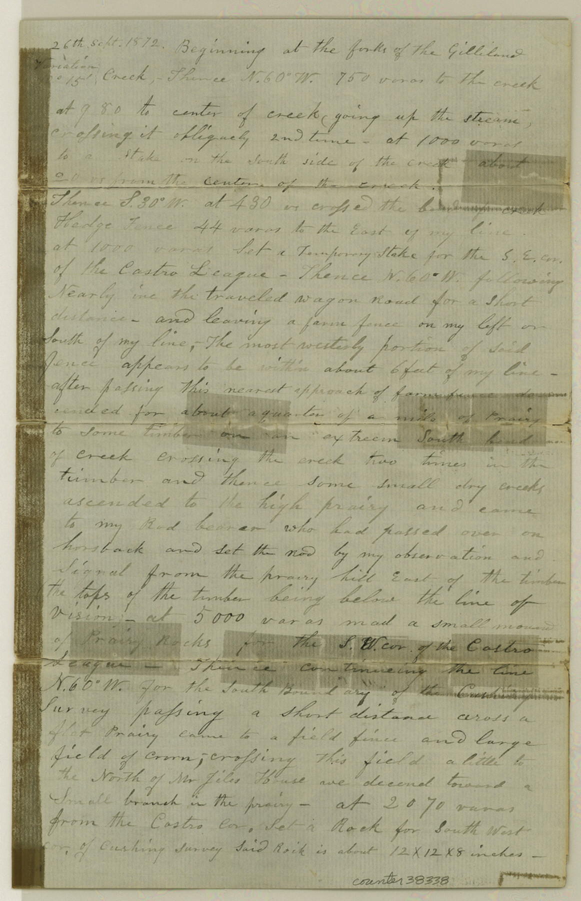
Travis County Sketch File 27
[Field notes of miscellaneous surveys throughout the county]
-
Map/Doc
38338
-
Collection
General Map Collection
-
Object Dates
9/27/1872 (Creation Date)
10/31/1872 (File Date)
-
People and Organizations
Reuben W. Ford (Surveyor/Engineer)
-
Counties
Travis
-
Subjects
Surveying Sketch File
-
Height x Width
12.9 x 8.3 inches
32.8 x 21.1 cm
-
Medium
paper, manuscript
-
Features
Gilliland Creek
Walnut Creek
Prairy [sic] Branch [of Gilliland Creek]
Part of: General Map Collection
Travis County Working Sketch 3

Print $20.00
- Digital $50.00
Travis County Working Sketch 3
1906
Size 19.5 x 15.0 inches
Map/Doc 69387
Sketch Showing surveys on Harbor Island in Nueces County

Print $20.00
- Digital $50.00
Sketch Showing surveys on Harbor Island in Nueces County
1951
Size 45.7 x 34.6 inches
Map/Doc 1915
Presidio County Sketch File 45

Print $6.00
- Digital $50.00
Presidio County Sketch File 45
1914
Size 11.3 x 8.8 inches
Map/Doc 34532
Brewster County Working Sketch 112

Print $20.00
- Digital $50.00
Brewster County Working Sketch 112
1982
Size 28.1 x 26.8 inches
Map/Doc 67712
Pecos County Sketch File 107

Print $4.00
- Digital $50.00
Pecos County Sketch File 107
Size 14.4 x 8.7 inches
Map/Doc 34035
Lipscomb County Boundary File 6

Print $4.00
- Digital $50.00
Lipscomb County Boundary File 6
Size 11.1 x 8.6 inches
Map/Doc 56329
Location of the Southern Kansas Railway of Texas

Print $40.00
- Digital $50.00
Location of the Southern Kansas Railway of Texas
1887
Size 19.0 x 103.2 inches
Map/Doc 64182
Ochiltree County

Print $20.00
- Digital $50.00
Ochiltree County
1908
Size 42.5 x 40.6 inches
Map/Doc 66959
Jackson County Sketch File 7

Print $24.00
- Digital $50.00
Jackson County Sketch File 7
1895
Size 14.2 x 8.7 inches
Map/Doc 27649
Flight Mission No. DCL-5C, Frame 3, Kenedy County

Print $20.00
- Digital $50.00
Flight Mission No. DCL-5C, Frame 3, Kenedy County
1943
Size 18.4 x 22.2 inches
Map/Doc 85828
Atascosa County Sketch File 39

Print $8.00
- Digital $50.00
Atascosa County Sketch File 39
1880
Size 12.2 x 8.0 inches
Map/Doc 13831
Terry County Working Sketch 1

Print $20.00
- Digital $50.00
Terry County Working Sketch 1
1938
Size 24.0 x 19.9 inches
Map/Doc 62106
You may also like
Franklin County Sketch File 1c

Print $4.00
- Digital $50.00
Franklin County Sketch File 1c
1853
Size 10.3 x 8.1 inches
Map/Doc 23010
Presidio County Rolled Sketch D1

Print $20.00
- Digital $50.00
Presidio County Rolled Sketch D1
Size 18.7 x 16.1 inches
Map/Doc 78524
Brewster County Sketch File N-3a

Print $40.00
- Digital $50.00
Brewster County Sketch File N-3a
Size 14.5 x 18.9 inches
Map/Doc 10962
Hunt County, Texas

Print $20.00
- Digital $50.00
Hunt County, Texas
1871
Size 25.8 x 19.4 inches
Map/Doc 462

Potter County Rolled Sketch 12

Print $20.00
- Digital $50.00
Potter County Rolled Sketch 12
2004
Size 18.8 x 24.7 inches
Map/Doc 82480
Travis County Rolled Sketch 41

Print $20.00
- Digital $50.00
Travis County Rolled Sketch 41
Size 31.3 x 24.7 inches
Map/Doc 8039
Flight Mission No. CGI-3N, Frame 77, Cameron County

Print $20.00
- Digital $50.00
Flight Mission No. CGI-3N, Frame 77, Cameron County
1954
Size 18.6 x 22.2 inches
Map/Doc 84571
Anderson County Sketch File 16a

Print $4.00
- Digital $50.00
Anderson County Sketch File 16a
1853
Size 12.3 x 8.3 inches
Map/Doc 12786
Map of Concho County, Texas

Print $20.00
- Digital $50.00
Map of Concho County, Texas
1879
Size 28.8 x 23.9 inches
Map/Doc 703
Sterling County Sketch File 25

Print $4.00
- Digital $50.00
Sterling County Sketch File 25
1892
Size 11.1 x 8.9 inches
Map/Doc 37192
Trinity County Sketch File 34

Print $20.00
- Digital $50.00
Trinity County Sketch File 34
Size 15.9 x 20.3 inches
Map/Doc 12491