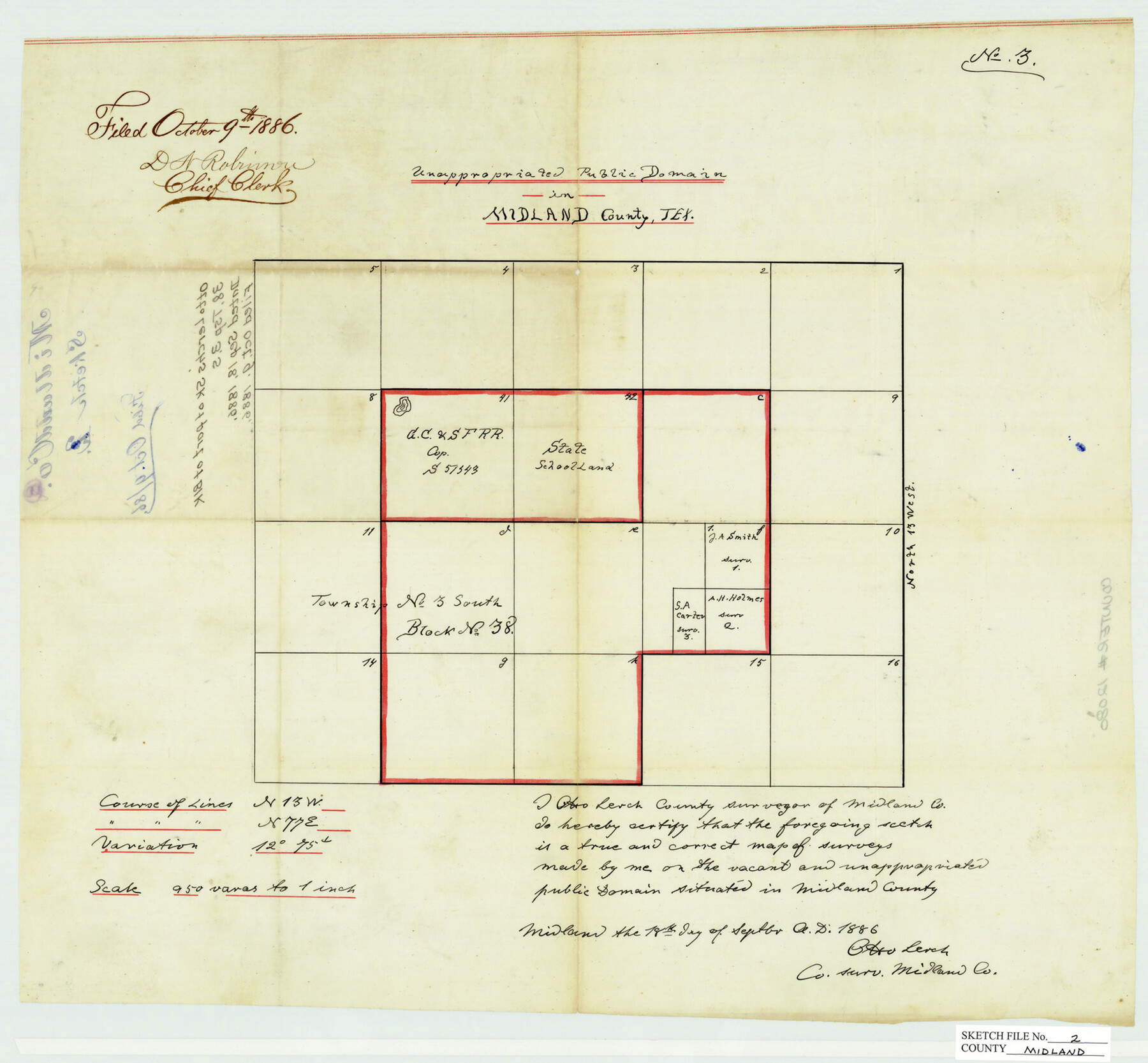
Midland County Sketch File 2
Unappropriated Public Domain in Midland County, Texas
-
Map/Doc
12080
-
Collection
General Map Collection
-
Object Dates
9/17/1886 (Creation Date)
10/9/1886 (File Date)
-
People and Organizations
Otto Lerch (Surveyor/Engineer)
-
Counties
Midland
-
Subjects
Surveying Sketch File
-
Height x Width
16.3 x 17.6 inches
41.4 x 44.7 cm
-
Medium
paper, manuscript
-
Scale
1:950
Part of: General Map Collection
Grayson County Sketch File 22

Print $4.00
- Digital $50.00
Grayson County Sketch File 22
1871
Size 10.4 x 8.4 inches
Map/Doc 24501
Hartley County Sketch File 6

Print $20.00
- Digital $50.00
Hartley County Sketch File 6
Size 30.5 x 25.6 inches
Map/Doc 11698
Sutton County Working Sketch 56

Print $20.00
- Digital $50.00
Sutton County Working Sketch 56
1958
Size 27.6 x 28.8 inches
Map/Doc 62399
Houston County Working Sketch 17

Print $40.00
- Digital $50.00
Houston County Working Sketch 17
1968
Size 43.4 x 50.3 inches
Map/Doc 66247
Liberty County Working Sketch 89

Print $20.00
- Digital $50.00
Liberty County Working Sketch 89
1993
Size 45.0 x 26.2 inches
Map/Doc 70549
University Land Field Notes for Block 19 in Loving and Ward Counties, Block 20 in Loving, Ward, and Winkler Counties, Blocks 16 and 18 in Ward County, Block 17 in Ward and Winkler Counties, and Block 21 in Winkler County

University Land Field Notes for Block 19 in Loving and Ward Counties, Block 20 in Loving, Ward, and Winkler Counties, Blocks 16 and 18 in Ward County, Block 17 in Ward and Winkler Counties, and Block 21 in Winkler County
Map/Doc 81709
Fort Bend County Working Sketch 30

Print $20.00
- Digital $50.00
Fort Bend County Working Sketch 30
1983
Size 13.6 x 13.6 inches
Map/Doc 69236
Map of Yoakum County

Print $40.00
- Digital $50.00
Map of Yoakum County
1900
Size 51.2 x 38.7 inches
Map/Doc 4169
Liberty County Rolled Sketch WC

Print $107.00
- Digital $50.00
Liberty County Rolled Sketch WC
1934
Size 10.4 x 15.3 inches
Map/Doc 46561
Flight Mission No. BRA-8M, Frame 72, Jefferson County

Print $20.00
- Digital $50.00
Flight Mission No. BRA-8M, Frame 72, Jefferson County
1953
Size 18.6 x 22.2 inches
Map/Doc 85592
Live Oak County Working Sketch 36

Print $20.00
- Digital $50.00
Live Oak County Working Sketch 36
2008
Size 33.5 x 35.8 inches
Map/Doc 88879
United States

Print $20.00
- Digital $50.00
United States
1851
Size 10.8 x 15.1 inches
Map/Doc 93799
You may also like

Little River, Faubion Bridge Sheet

Print $4.00
- Digital $50.00
Little River, Faubion Bridge Sheet
1914
Size 19.0 x 27.8 inches
Map/Doc 65060
Smith County Rolled Sketch 6A1

Print $40.00
- Digital $50.00
Smith County Rolled Sketch 6A1
Size 49.2 x 38.6 inches
Map/Doc 10704

Castro County Sketch File 4a

Print $4.00
- Digital $50.00
Castro County Sketch File 4a
Size 6.2 x 8.5 inches
Map/Doc 17465
Gaines County Rolled Sketch 25

Print $20.00
- Digital $50.00
Gaines County Rolled Sketch 25
1977
Size 23.6 x 19.4 inches
Map/Doc 5939
Flight Mission No. DQN-2K, Frame 41, Calhoun County

Print $20.00
- Digital $50.00
Flight Mission No. DQN-2K, Frame 41, Calhoun County
1953
Size 18.5 x 22.2 inches
Map/Doc 84246
Kinney County Rolled Sketch 15

Print $20.00
- Digital $50.00
Kinney County Rolled Sketch 15
Size 28.2 x 43.4 inches
Map/Doc 9354
Travis County Rolled Sketch 29

Print $20.00
- Digital $50.00
Travis County Rolled Sketch 29
1946
Size 25.1 x 37.8 inches
Map/Doc 8031
Crockett County Working Sketch 25

Print $20.00
- Digital $50.00
Crockett County Working Sketch 25
1921
Size 23.5 x 17.6 inches
Map/Doc 68358
Bandera County Working Sketch 26

Print $20.00
- Digital $50.00
Bandera County Working Sketch 26
1951
Size 32.3 x 28.4 inches
Map/Doc 67622
Alexander's Subdivision Tract 2, League 64 Midland County School Land, Cochran County, Texas

Print $20.00
- Digital $50.00
Alexander's Subdivision Tract 2, League 64 Midland County School Land, Cochran County, Texas
1937
Size 19.1 x 22.7 inches
Map/Doc 92518