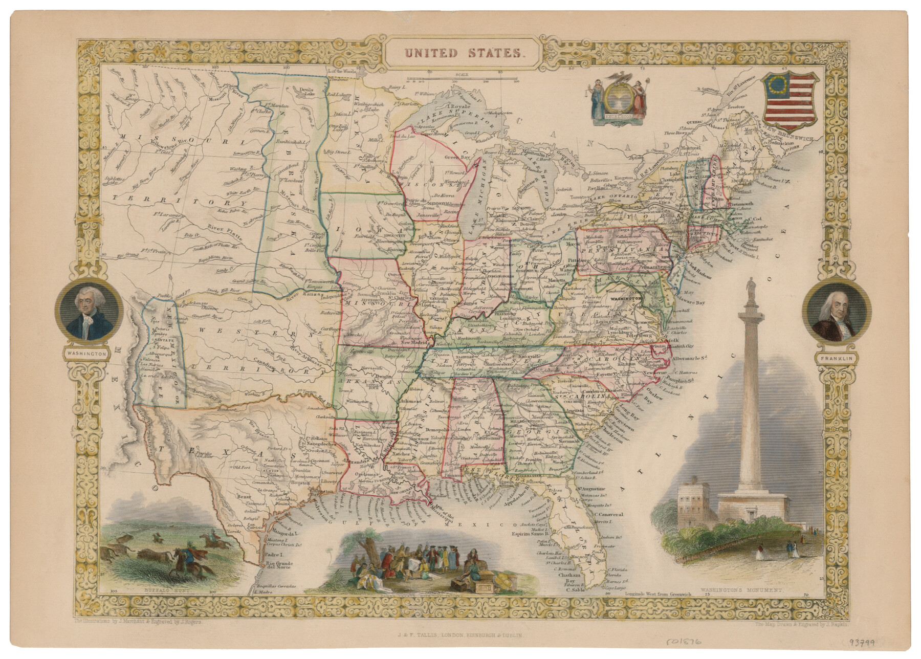
United States
-
Map/Doc
93799
-
Collection
General Map Collection
-
Object Dates
1851 (Creation Date)
2015/7/24 (File Date)
-
People and Organizations
J. & F. Tallis (Publisher)
J. Rapkin (Printer)
[J. & F. Tallis] (Author)
J. Rapkin (Draftsman)
J. Rogers (Engraver)
J. Marchant (Illustrator)
J. Rapkin (Engraver)
John Tallis (Cartographer)
-
Subjects
United States
-
Height x Width
10.8 x 15.1 inches
27.4 x 38.4 cm
-
Medium
paper, etching/engraving/lithograph
-
Comments
Illustrations by J. Marchant and engraved by J. Rogers.
-
URLs
https://medium.com/save-texas-history/mapping-texas-from-frontier-to-the-lone-star-state-the-lone-star-state-260313aafcd1
Part of: General Map Collection


Burnet County Sketch File 31

Print $4.00
- Digital $50.00
Burnet County Sketch File 31
1875
Size 12.7 x 8.1 inches
Map/Doc 16748
Denton County

Print $20.00
- Digital $50.00
Denton County
1947
Size 42.5 x 39.7 inches
Map/Doc 73130
Flight Mission No. CLL-1N, Frame 21, Willacy County

Print $20.00
- Digital $50.00
Flight Mission No. CLL-1N, Frame 21, Willacy County
1954
Size 18.7 x 22.3 inches
Map/Doc 87008
Wilson County Working Sketch 9

Print $20.00
- Digital $50.00
Wilson County Working Sketch 9
1979
Size 31.6 x 33.0 inches
Map/Doc 72589
Loving County Rolled Sketch 5

Print $40.00
- Digital $50.00
Loving County Rolled Sketch 5
1952
Size 146.0 x 14.2 inches
Map/Doc 9467
Duval County Rolled Sketch 51

Print $20.00
- Digital $50.00
Duval County Rolled Sketch 51
Size 19.1 x 16.9 inches
Map/Doc 5765
Atascosa County Sketch File 26

Print $4.00
- Digital $50.00
Atascosa County Sketch File 26
Size 8.2 x 12.7 inches
Map/Doc 13794
Fort Bend County Rolled Sketch T

Print $20.00
- Digital $50.00
Fort Bend County Rolled Sketch T
1930
Size 28.7 x 25.8 inches
Map/Doc 5908
Starr County Rolled Sketch 46A

Print $20.00
- Digital $50.00
Starr County Rolled Sketch 46A
1986
Size 17.9 x 34.4 inches
Map/Doc 7837
Runnels County Sketch File 25

Print $20.00
Runnels County Sketch File 25
1940
Size 16.5 x 16.7 inches
Map/Doc 12259
You may also like
Right of Way and Track Map International & Gt. Northern Ry. operated by the International & Gt. Northern Ry. Co., Columbia Branch, Gulf Division

Print $40.00
- Digital $50.00
Right of Way and Track Map International & Gt. Northern Ry. operated by the International & Gt. Northern Ry. Co., Columbia Branch, Gulf Division
1917
Size 25.0 x 56.8 inches
Map/Doc 64599
Aransas County Rolled Sketch 24A

Print $20.00
- Digital $50.00
Aransas County Rolled Sketch 24A
Size 15.8 x 24.1 inches
Map/Doc 5062

Armstrong County Sketch File 8

Print $8.00
- Digital $50.00
Armstrong County Sketch File 8
Size 14.2 x 8.8 inches
Map/Doc 13705
Howard County Sketch File 11

Print $40.00
- Digital $50.00
Howard County Sketch File 11
1937
Size 17.6 x 10.2 inches
Map/Doc 26865
Map Prepared from Data in Original Field Book by W.D. Twichell

Print $40.00
- Digital $50.00
Map Prepared from Data in Original Field Book by W.D. Twichell
Size 64.2 x 39.9 inches
Map/Doc 89750
The Republic County of Matagorda. September 17, 1838

Print $20.00
The Republic County of Matagorda. September 17, 1838
2020
Size 21.0 x 21.7 inches
Map/Doc 96217
Edwards County Working Sketch 60

Print $20.00
- Digital $50.00
Edwards County Working Sketch 60
1954
Size 20.5 x 43.7 inches
Map/Doc 68936
Map Showing Eastern Portion of Pecos County, Texas

Print $40.00
- Digital $50.00
Map Showing Eastern Portion of Pecos County, Texas
Size 62.2 x 43.5 inches
Map/Doc 89835
Map of the Fort Worth & Denver City Railway, Oldham County, Texas

Print $40.00
- Digital $50.00
Map of the Fort Worth & Denver City Railway, Oldham County, Texas
1887
Size 24.8 x 105.2 inches
Map/Doc 64456
[Texas and Pacific Blocks 56-62, Townships 1-3]
![90501, [Texas and Pacific Blocks 56-62, Townships 1-3], Twichell Survey Records](https://historictexasmaps.com/wmedia_w700/maps/90501-1.tif.jpg)
Print $20.00
- Digital $50.00
[Texas and Pacific Blocks 56-62, Townships 1-3]
1885
Size 28.4 x 15.9 inches
Map/Doc 90501
Dimmit County

Print $40.00
- Digital $50.00
Dimmit County
1916
Size 40.6 x 48.0 inches
Map/Doc 78341