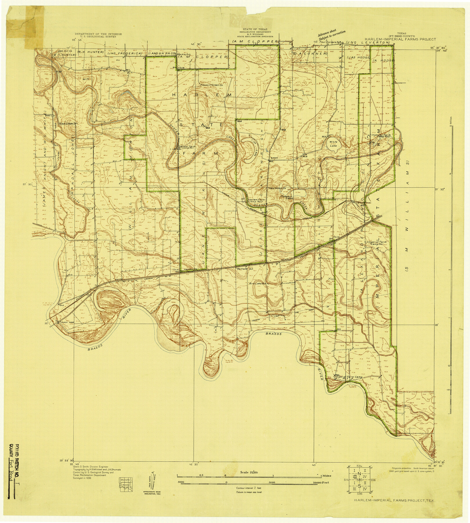
Fort Bend County Rolled Sketch T
Harlem-Imperial Farms Project [USGS Topographic sheet]
-
Map/Doc
5908
-
Collection
General Map Collection
-
Object Dates
1930 (Creation Date)
-
Counties
Fort Bend
-
Subjects
Prison Farms Surveying Rolled Sketch Topographic
-
Height x Width
28.7 x 25.8 inches
72.9 x 65.5 cm
-
Medium
paper, print with manuscript additions
Part of: General Map Collection
Brewster County Rolled Sketch 115

Print $40.00
- Digital $50.00
Brewster County Rolled Sketch 115
1958
Size 11.5 x 138.4 inches
Map/Doc 8514
Presidio County Sketch File 35B

Print $20.00
- Digital $50.00
Presidio County Sketch File 35B
1906
Size 11.8 x 20.7 inches
Map/Doc 11714
Map showing the fortification at Point Isabel

Print $20.00
- Digital $50.00
Map showing the fortification at Point Isabel
1864
Size 18.3 x 27.9 inches
Map/Doc 72921
Polk County Rolled Sketch 23

Print $20.00
- Digital $50.00
Polk County Rolled Sketch 23
Size 29.1 x 23.5 inches
Map/Doc 7313
Jefferson County Rolled Sketch 49

Print $40.00
- Digital $50.00
Jefferson County Rolled Sketch 49
1963
Size 32.5 x 57.4 inches
Map/Doc 66844
Val Verde County Sketch File N

Print $14.00
- Digital $50.00
Val Verde County Sketch File N
1920
Size 10.9 x 8.8 inches
Map/Doc 39284
Flight Mission No. CUG-2P, Frame 59, Kleberg County

Print $20.00
- Digital $50.00
Flight Mission No. CUG-2P, Frame 59, Kleberg County
1956
Size 18.4 x 22.1 inches
Map/Doc 86196
Runnels County Sketch File 6a

Print $4.00
Runnels County Sketch File 6a
1883
Size 12.9 x 8.2 inches
Map/Doc 35442
Bandera County

Print $40.00
- Digital $50.00
Bandera County
1904
Size 33.0 x 52.5 inches
Map/Doc 66710
Flight Mission No. CRC-1R, Frame 39, Chambers County

Print $20.00
- Digital $50.00
Flight Mission No. CRC-1R, Frame 39, Chambers County
1956
Size 18.8 x 22.4 inches
Map/Doc 84707
Jefferson County Rolled Sketch 3

Print $20.00
- Digital $50.00
Jefferson County Rolled Sketch 3
1909
Size 36.0 x 16.2 inches
Map/Doc 6384
Sherman County Sketch File D

Print $5.00
- Digital $50.00
Sherman County Sketch File D
1959
Size 10.6 x 8.9 inches
Map/Doc 36721
You may also like
Llano County Sketch File 8

Print $10.00
- Digital $50.00
Llano County Sketch File 8
1885
Size 14.1 x 8.8 inches
Map/Doc 30364
Duval County Rolled Sketch Pressly No. 1A

Print $20.00
- Digital $50.00
Duval County Rolled Sketch Pressly No. 1A
1935
Size 25.4 x 37.6 inches
Map/Doc 5769
Concho County Sketch File 3

Print $6.00
- Digital $50.00
Concho County Sketch File 3
1857
Size 13.1 x 8.4 inches
Map/Doc 19124
Leon County Working Sketch 45

Print $20.00
- Digital $50.00
Leon County Working Sketch 45
1980
Size 45.4 x 37.4 inches
Map/Doc 70444
Trinity River, South Extension Porters Bluff Sheet

Print $20.00
- Digital $50.00
Trinity River, South Extension Porters Bluff Sheet
1925
Size 16.3 x 24.4 inches
Map/Doc 69690
Nueces County Rolled Sketch 89

Print $235.00
Nueces County Rolled Sketch 89
1983
Size 18.0 x 24.2 inches
Map/Doc 6991
Sherman County Rolled Sketch 12

Print $40.00
- Digital $50.00
Sherman County Rolled Sketch 12
1951
Size 11.5 x 64.0 inches
Map/Doc 9931
Culberson County Working Sketch 40a

Print $20.00
- Digital $50.00
Culberson County Working Sketch 40a
1981
Size 37.3 x 38.6 inches
Map/Doc 68494
Flight Mission No. DQO-7K, Frame 107, Galveston County

Print $20.00
- Digital $50.00
Flight Mission No. DQO-7K, Frame 107, Galveston County
1952
Size 18.6 x 22.6 inches
Map/Doc 85122
Gregg County Rolled Sketch 23

Print $40.00
- Digital $50.00
Gregg County Rolled Sketch 23
Size 52.9 x 43.3 inches
Map/Doc 9074
General Highway Map, Presidio County, Texas

Print $20.00
General Highway Map, Presidio County, Texas
1961
Size 24.5 x 18.3 inches
Map/Doc 79633
Edwards County Working Sketch 33

Print $40.00
- Digital $50.00
Edwards County Working Sketch 33
1947
Size 42.6 x 50.2 inches
Map/Doc 68909