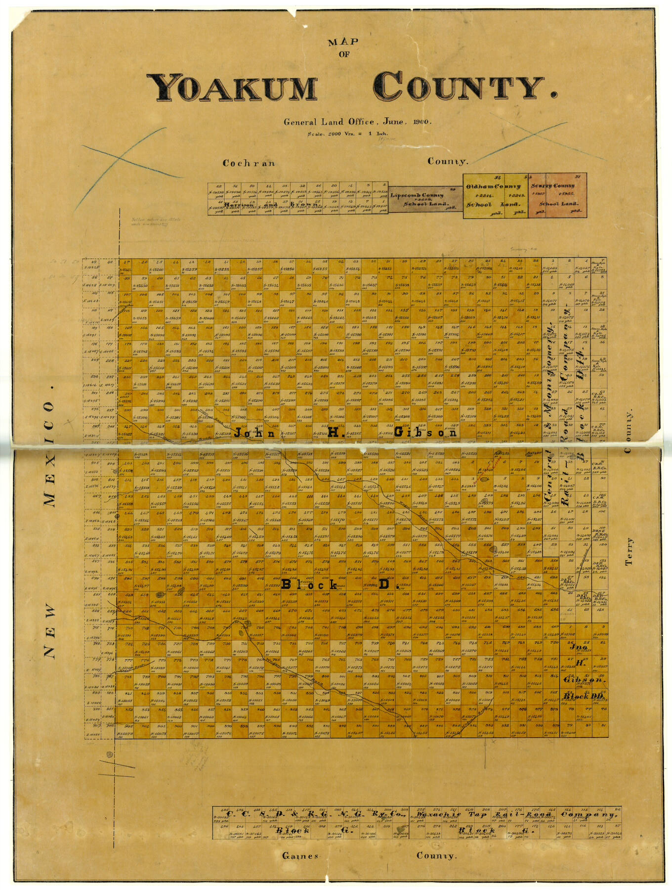
Map of Yoakum County
-
Map/Doc
4169
-
Collection
General Map Collection
-
Object Dates
1900 (Creation Date)
-
People and Organizations
Texas General Land Office (Publisher)
Amos Wynne (Draftsman)
Amos Wynne (Compiler)
-
Counties
Yoakum
-
Subjects
County
-
Height x Width
51.2 x 38.7 inches
130.0 x 98.3 cm
-
Features
Wagon Road
Part of: General Map Collection
Terrell County Rolled Sketch 24

Print $20.00
- Digital $50.00
Terrell County Rolled Sketch 24
Size 19.7 x 25.7 inches
Map/Doc 7931
Duval County Sketch File 22

Print $20.00
- Digital $50.00
Duval County Sketch File 22
1880
Size 31.9 x 23.2 inches
Map/Doc 11386
Harris County Rolled Sketch 89

Print $20.00
- Digital $50.00
Harris County Rolled Sketch 89
1899
Size 22.1 x 35.3 inches
Map/Doc 6128
Flight Mission No. CUG-2P, Frame 79, Kleberg County

Print $20.00
- Digital $50.00
Flight Mission No. CUG-2P, Frame 79, Kleberg County
1956
Size 18.4 x 22.1 inches
Map/Doc 86211
Flight Mission No. CRC-3R, Frame 197, Chambers County

Print $20.00
- Digital $50.00
Flight Mission No. CRC-3R, Frame 197, Chambers County
1956
Size 18.5 x 22.3 inches
Map/Doc 84852
Anderson County

Print $20.00
- Digital $50.00
Anderson County
1871
Size 20.2 x 21.9 inches
Map/Doc 3227
Brazos Santiago, Texas

Print $20.00
- Digital $50.00
Brazos Santiago, Texas
1882
Size 9.0 x 16.9 inches
Map/Doc 97186
Flight Mission No. CUG-3P, Frame 23, Kleberg County

Print $20.00
- Digital $50.00
Flight Mission No. CUG-3P, Frame 23, Kleberg County
1956
Size 18.5 x 22.3 inches
Map/Doc 86233
Map of the Houston and G. N. R.R. and lands adjacent, from Troupe to the Texas Pacific R.R.

Print $40.00
- Digital $50.00
Map of the Houston and G. N. R.R. and lands adjacent, from Troupe to the Texas Pacific R.R.
Size 21.2 x 92.0 inches
Map/Doc 64627
Galveston County Sketch File 2a

Print $4.00
- Digital $50.00
Galveston County Sketch File 2a
1848
Size 14.3 x 8.8 inches
Map/Doc 23350
Mills County Rolled Sketch 1

Print $20.00
- Digital $50.00
Mills County Rolled Sketch 1
Size 29.6 x 30.4 inches
Map/Doc 6779
Wichita County Sketch File D

Print $22.00
- Digital $50.00
Wichita County Sketch File D
1919
Size 12.0 x 8.6 inches
Map/Doc 40061
You may also like
Sketch for Blocks D6, D7, D8 situated in Val Verde County, Texas

Print $40.00
- Digital $50.00
Sketch for Blocks D6, D7, D8 situated in Val Verde County, Texas
1937
Size 100.1 x 40.0 inches
Map/Doc 93166
[Area to the West and North of the Abraham Winfrey survey 11]
![90228, [Area to the West and North of the Abraham Winfrey survey 11], Twichell Survey Records](https://historictexasmaps.com/wmedia_w700/maps/90228-1.tif.jpg)
Print $20.00
- Digital $50.00
[Area to the West and North of the Abraham Winfrey survey 11]
1920
Size 23.2 x 24.1 inches
Map/Doc 90228
Map of Liberty County Texas

Print $20.00
- Digital $50.00
Map of Liberty County Texas
1879
Size 24.2 x 23.9 inches
Map/Doc 3814
Wharton County Sketch File 25

Print $4.00
- Digital $50.00
Wharton County Sketch File 25
1978
Size 11.1 x 8.7 inches
Map/Doc 39988
Bell County Working Sketch 18

Print $20.00
- Digital $50.00
Bell County Working Sketch 18
1984
Size 36.2 x 29.8 inches
Map/Doc 67358
Jeff Davis County Sketch File 26 1/2

Print $10.00
- Digital $50.00
Jeff Davis County Sketch File 26 1/2
Size 9.0 x 10.4 inches
Map/Doc 27999
Uvalde County

Print $20.00
- Digital $50.00
Uvalde County
1976
Size 43.0 x 46.3 inches
Map/Doc 95660
Presidio County Working Sketch 56

Print $20.00
- Digital $50.00
Presidio County Working Sketch 56
1955
Size 13.9 x 22.0 inches
Map/Doc 71733
Bandera County Working Sketch 15

Print $20.00
- Digital $50.00
Bandera County Working Sketch 15
1938
Size 18.1 x 17.4 inches
Map/Doc 67608

Limestone County Working Sketch 25

Print $20.00
- Digital $50.00
Limestone County Working Sketch 25
1981
Size 26.1 x 21.1 inches
Map/Doc 70575
[North 1/2 of Garza County, South 1/2 of Crosby County]
![90908, [North 1/2 of Garza County, South 1/2 of Crosby County], Twichell Survey Records](https://historictexasmaps.com/wmedia_w700/maps/90908-1.tif.jpg)
Print $20.00
- Digital $50.00
[North 1/2 of Garza County, South 1/2 of Crosby County]
Size 34.7 x 31.1 inches
Map/Doc 90908