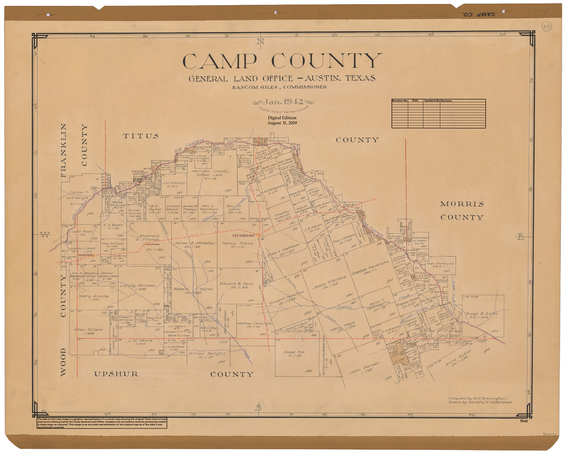
Camp County
General Land Office Official County Map
-
Map/Doc
95448
-
Collection
General Map Collection
-
Object Dates
2019/8/31 (Revision Date)
1942 (Creation Date)
-
People and Organizations
Cheyenne Betancourt (Draftsman)
Dorothy H. Underwood (Draftsman)
W. S. Brewington (Compiler)
Bascom Giles (GLO Commissioner)
-
Counties
Camp
-
Subjects
County OCM
-
Height x Width
25.7 x 32.0 inches
65.3 x 81.3 cm
-
Medium
digital image
-
Scale
1" = 2000 varas
Part of: General Map Collection
Railroad Track Map, T&PRRCo., Culberson County, Texas

Print $4.00
- Digital $50.00
Railroad Track Map, T&PRRCo., Culberson County, Texas
1910
Size 11.8 x 18.6 inches
Map/Doc 62828
Dickens County Sketch File 38

Print $4.00
- Digital $50.00
Dickens County Sketch File 38
1904
Size 10.8 x 7.3 inches
Map/Doc 21048
Newton County Rolled Sketch 4

Print $20.00
- Digital $50.00
Newton County Rolled Sketch 4
1893
Size 21.1 x 19.7 inches
Map/Doc 6840
McCulloch County Rolled Sketch 4

Print $40.00
- Digital $50.00
McCulloch County Rolled Sketch 4
1901
Size 48.4 x 14.1 inches
Map/Doc 9498
Map of Taylor County Travis- Young- Bexar- Land District

Print $20.00
- Digital $50.00
Map of Taylor County Travis- Young- Bexar- Land District
1859
Size 25.1 x 20.4 inches
Map/Doc 4071
Lynn County Boundary File 3

Print $6.00
- Digital $50.00
Lynn County Boundary File 3
Size 6.3 x 8.8 inches
Map/Doc 56623
Tom Green County Boundary File 87

Print $10.00
- Digital $50.00
Tom Green County Boundary File 87
Size 9.1 x 4.0 inches
Map/Doc 59393

Taylor County Working Sketch 7

Print $20.00
- Digital $50.00
Taylor County Working Sketch 7
1953
Size 41.3 x 16.1 inches
Map/Doc 69617
Brewster County Working Sketch 94

Print $40.00
- Digital $50.00
Brewster County Working Sketch 94
1975
Size 58.7 x 39.5 inches
Map/Doc 67694
Bee County Boundary File 6

Print $4.00
- Digital $50.00
Bee County Boundary File 6
Size 10.4 x 7.9 inches
Map/Doc 50458
Cochran County

Print $20.00
- Digital $50.00
Cochran County
1946
Size 33.3 x 25.5 inches
Map/Doc 95456
You may also like
Flight Mission No. DQN-1K, Frame 129, Calhoun County

Print $20.00
- Digital $50.00
Flight Mission No. DQN-1K, Frame 129, Calhoun County
1953
Size 18.5 x 22.2 inches
Map/Doc 84192
Township No. 5 South, Range No. 14 West, Indian Meridian, Oklahoma

Print $4.00
- Digital $50.00
Township No. 5 South, Range No. 14 West, Indian Meridian, Oklahoma
1928
Size 18.0 x 22.6 inches
Map/Doc 75141
Live Oak County Working Sketch 21

Print $20.00
- Digital $50.00
Live Oak County Working Sketch 21
1964
Size 30.8 x 33.9 inches
Map/Doc 70606
[T. & P. Block 44, Township 1S]
![90926, [T. & P. Block 44, Township 1S], Twichell Survey Records](https://historictexasmaps.com/wmedia_w700/maps/90926-1.tif.jpg)
Print $20.00
- Digital $50.00
[T. & P. Block 44, Township 1S]
Size 17.6 x 22.6 inches
Map/Doc 90926
Val Verde County Rolled Sketch 84

Print $20.00
- Digital $50.00
Val Verde County Rolled Sketch 84
2006
Size 31.2 x 35.4 inches
Map/Doc 84802
Sutton County Working Sketch 54

Print $20.00
- Digital $50.00
Sutton County Working Sketch 54
1957
Size 28.0 x 38.4 inches
Map/Doc 62397
Flight Mission No. CUG-1P, Frame 72, Kleberg County

Print $20.00
- Digital $50.00
Flight Mission No. CUG-1P, Frame 72, Kleberg County
1956
Size 18.6 x 22.1 inches
Map/Doc 86137
Amistad International Reservoir on Rio Grande 85

Print $20.00
- Digital $50.00
Amistad International Reservoir on Rio Grande 85
1949
Size 28.4 x 40.2 inches
Map/Doc 75514
Webb County Working Sketch 14

Print $20.00
- Digital $50.00
Webb County Working Sketch 14
1923
Size 19.3 x 32.2 inches
Map/Doc 72379
Flight Mission No. CRC-5R, Frame 39, Chambers County

Print $20.00
- Digital $50.00
Flight Mission No. CRC-5R, Frame 39, Chambers County
1956
Size 18.5 x 22.3 inches
Map/Doc 84958
Childress Co.

Print $20.00
- Digital $50.00
Childress Co.
1978
Size 44.6 x 33.7 inches
Map/Doc 77237
Flight Mission No. DCL-6C, Frame 28, Kenedy County

Print $20.00
- Digital $50.00
Flight Mission No. DCL-6C, Frame 28, Kenedy County
1943
Size 18.7 x 22.4 inches
Map/Doc 85885