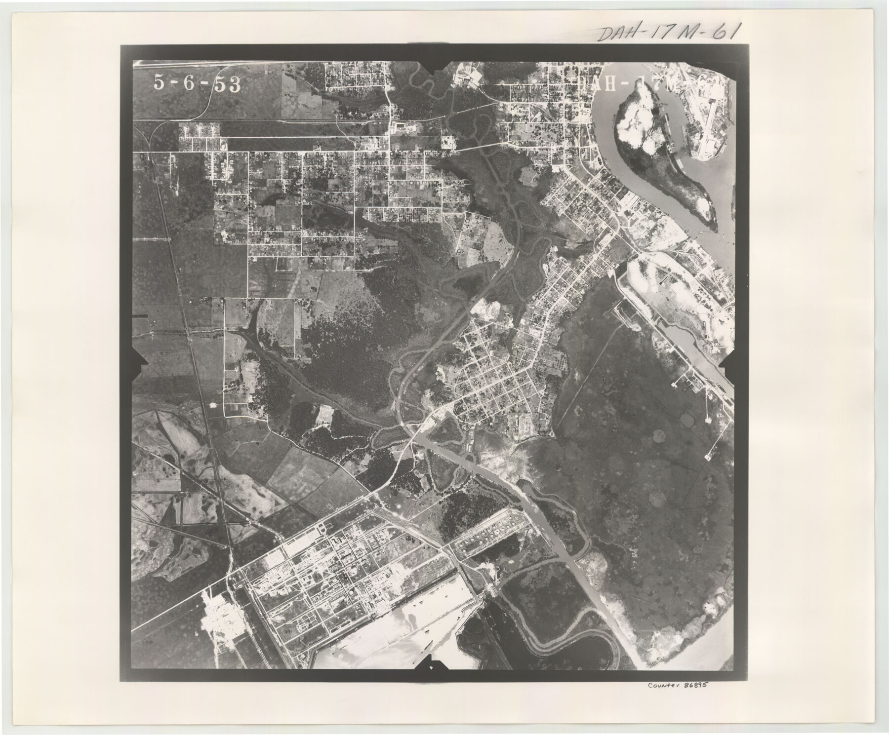
Flight Mission No. DAH-17M, Frame 61, Orange County
DAH-17M-61
-
Map/Doc
86895
-
Collection
General Map Collection
-
Object Dates
1953/5/6 (Creation Date)
-
People and Organizations
U. S. Department of Agriculture (Publisher)
-
Counties
Orange
-
Subjects
Aerial Photograph
-
Height x Width
18.6 x 22.5 inches
47.2 x 57.2 cm
-
Comments
Flown by Jack Ammann Photogrammetric Engineers of San Antonio, Texas.
Part of: General Map Collection
Map of Brazoria

Print $20.00
- Digital $50.00
Map of Brazoria
1863
Size 27.4 x 27.3 inches
Map/Doc 1013
Webb County Working Sketch 10

Print $20.00
- Digital $50.00
Webb County Working Sketch 10
1913
Size 23.7 x 20.0 inches
Map/Doc 72375
Crockett County Rolled Sketch 91

Print $40.00
- Digital $50.00
Crockett County Rolled Sketch 91
1928
Size 26.0 x 70.5 inches
Map/Doc 8737
Sterling County Rolled Sketch 25

Print $20.00
- Digital $50.00
Sterling County Rolled Sketch 25
Size 31.4 x 35.3 inches
Map/Doc 9955
Maps of Gulf Intracoastal Waterway, Texas - Sabine River to the Rio Grande and connecting waterways including ship channels

Print $20.00
- Digital $50.00
Maps of Gulf Intracoastal Waterway, Texas - Sabine River to the Rio Grande and connecting waterways including ship channels
1966
Size 14.6 x 22.3 inches
Map/Doc 61925
McMullen County Working Sketch 17

Print $20.00
- Digital $50.00
McMullen County Working Sketch 17
1941
Size 35.1 x 21.8 inches
Map/Doc 70718
Hudspeth County Sketch File 16

Print $10.00
- Digital $50.00
Hudspeth County Sketch File 16
1925
Size 14.3 x 8.8 inches
Map/Doc 26948
Harris County Rolled Sketch 26

Print $20.00
- Digital $50.00
Harris County Rolled Sketch 26
Size 28.2 x 41.3 inches
Map/Doc 6094
Medina County Working Sketch 16

Print $20.00
- Digital $50.00
Medina County Working Sketch 16
1979
Size 27.1 x 28.2 inches
Map/Doc 70931
Cooke County Working Sketch 8

Print $20.00
- Digital $50.00
Cooke County Working Sketch 8
1940
Size 41.5 x 28.1 inches
Map/Doc 68245
Gillespie County Sketch File 11

Print $4.00
- Digital $50.00
Gillespie County Sketch File 11
1877
Size 8.3 x 12.8 inches
Map/Doc 24149
Nueces County Rolled Sketch 13

Print $20.00
- Digital $50.00
Nueces County Rolled Sketch 13
Size 22.1 x 28.9 inches
Map/Doc 6870
You may also like
[Capitol Leagues Eastward from Bl, LC2 to H. & T.C. Blk. 44]
![89922, [Capitol Leagues Eastward from Bl, LC2 to H. & T.C. Blk. 44], Twichell Survey Records](https://historictexasmaps.com/wmedia_w700/maps/89922-1.tif.jpg)
Print $40.00
- Digital $50.00
[Capitol Leagues Eastward from Bl, LC2 to H. & T.C. Blk. 44]
Size 64.0 x 38.5 inches
Map/Doc 89922
Jeff Davis County Sketch File 11

Print $20.00
- Digital $50.00
Jeff Davis County Sketch File 11
Size 17.7 x 29.9 inches
Map/Doc 11858
Jones County Sketch File 9

Print $22.00
- Digital $50.00
Jones County Sketch File 9
Size 8.3 x 7.5 inches
Map/Doc 28495
Polk County Sketch File 40

Print $4.00
- Digital $50.00
Polk County Sketch File 40
Size 10.9 x 8.5 inches
Map/Doc 34290
Upshur County Working Sketch 15b

Print $20.00
- Digital $50.00
Upshur County Working Sketch 15b
1996
Size 36.7 x 29.4 inches
Map/Doc 69572
PSL Field Notes for Blocks C13 and C14 in Jeff Davis and Reeves Counties, Block C17 in Culberson and Reeves Counties, and Blocks C11, C12, C15, C16, C18, C19, C20, and C21 in Reeves County

PSL Field Notes for Blocks C13 and C14 in Jeff Davis and Reeves Counties, Block C17 in Culberson and Reeves Counties, and Blocks C11, C12, C15, C16, C18, C19, C20, and C21 in Reeves County
Map/Doc 81672
[Area along West County Line]
![90833, [Area along West County Line], Twichell Survey Records](https://historictexasmaps.com/wmedia_w700/maps/90833-2.tif.jpg)
Print $2.00
- Digital $50.00
[Area along West County Line]
Size 7.0 x 9.6 inches
Map/Doc 90833
[Double Lakes Area Northwest of Tohoka, Block 3, Surveys 319, 321, and 322]
![91298, [Double Lakes Area Northwest of Tohoka, Block 3, Surveys 319, 321, and 322], Twichell Survey Records](https://historictexasmaps.com/wmedia_w700/maps/91298-1.tif.jpg)
Print $20.00
- Digital $50.00
[Double Lakes Area Northwest of Tohoka, Block 3, Surveys 319, 321, and 322]
Size 21.1 x 20.1 inches
Map/Doc 91298
Val Verde County Working Sketch 48

Print $20.00
- Digital $50.00
Val Verde County Working Sketch 48
1949
Size 32.6 x 17.6 inches
Map/Doc 72183
Hutchinson County Rolled Sketch 19

Print $20.00
- Digital $50.00
Hutchinson County Rolled Sketch 19
Size 21.3 x 25.0 inches
Map/Doc 6285
Palo Pinto County

Print $40.00
- Digital $50.00
Palo Pinto County
1941
Size 48.3 x 39.3 inches
Map/Doc 73256
[E. T. Ry. Blk. 1]
![89797, [E. T. Ry. Blk. 1], Twichell Survey Records](https://historictexasmaps.com/wmedia_w700/maps/89797-1.tif.jpg)
Print $40.00
- Digital $50.00
[E. T. Ry. Blk. 1]
Size 41.8 x 49.9 inches
Map/Doc 89797