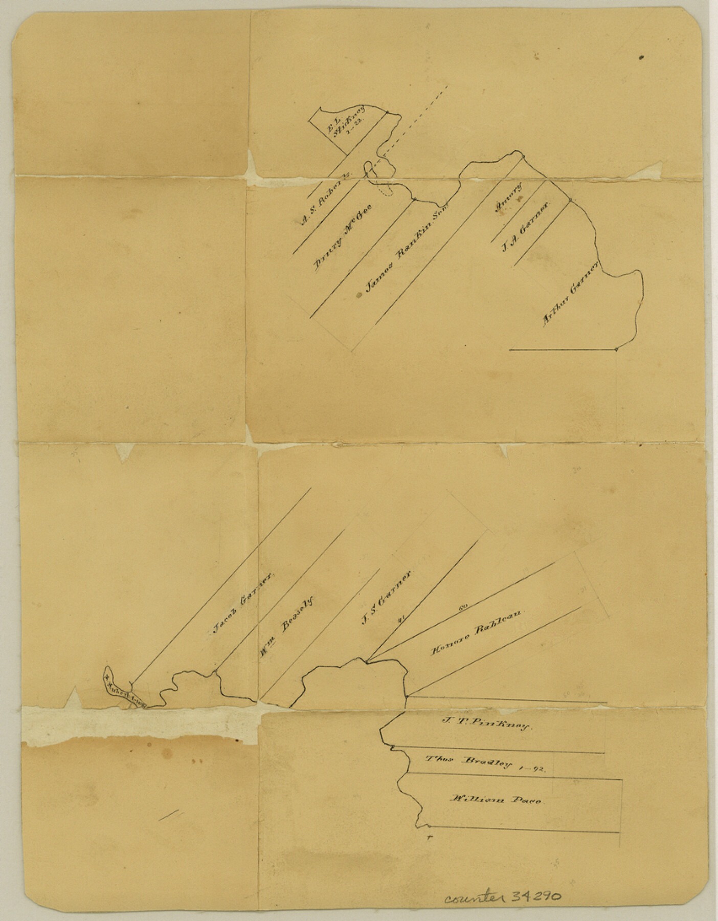
Polk County Sketch File 40
[Sketch around the J. T. Pinkney survey]
-
Map/Doc
34290
-
Collection
General Map Collection
-
Counties
Polk San Jacinto
-
Subjects
Surveying Sketch File
-
Height x Width
10.9 x 8.5 inches
27.7 x 21.6 cm
-
Medium
paper, manuscript
Part of: General Map Collection
Galveston County Aerial Photograph Index Sheet 1

Print $20.00
- Digital $50.00
Galveston County Aerial Photograph Index Sheet 1
1953
Size 23.4 x 19.2 inches
Map/Doc 83692
Willacy County Boundary File 2

Print $16.00
- Digital $50.00
Willacy County Boundary File 2
Size 11.0 x 8.7 inches
Map/Doc 59967
Flight Mission No. DAG-21K, Frame 29, Matagorda County

Print $20.00
- Digital $50.00
Flight Mission No. DAG-21K, Frame 29, Matagorda County
1952
Size 18.5 x 16.1 inches
Map/Doc 86396
[Gulf Colorado & Santa Fe from 2178+36.0 to 3901+06.2]
![64698, [Gulf Colorado & Santa Fe from 2178+36.0 to 3901+06.2], General Map Collection](https://historictexasmaps.com/wmedia_w700/maps/64698.tif.jpg)
Print $40.00
- Digital $50.00
[Gulf Colorado & Santa Fe from 2178+36.0 to 3901+06.2]
Size 123.0 x 32.2 inches
Map/Doc 64698
Stephens County Sketch File 10

Print $4.00
- Digital $50.00
Stephens County Sketch File 10
Size 10.8 x 8.4 inches
Map/Doc 37042
Franklin County Sketch File 5

Print $2.00
- Digital $50.00
Franklin County Sketch File 5
Size 8.2 x 10.7 inches
Map/Doc 23017
Flight Mission No. DCL-6C, Frame 79, Kenedy County

Print $20.00
- Digital $50.00
Flight Mission No. DCL-6C, Frame 79, Kenedy County
1943
Size 18.6 x 22.4 inches
Map/Doc 85921
Blanco County Working Sketch 18

Print $20.00
- Digital $50.00
Blanco County Working Sketch 18
1912
Size 19.0 x 15.9 inches
Map/Doc 67378
Chambers County Working Sketch 21

Print $20.00
- Digital $50.00
Chambers County Working Sketch 21
1974
Size 44.1 x 34.8 inches
Map/Doc 68004
Cass County Working Sketch 11

Print $3.00
- Digital $50.00
Cass County Working Sketch 11
Size 14.8 x 10.3 inches
Map/Doc 67914
Chambers County Working Sketch 17

Print $20.00
- Digital $50.00
Chambers County Working Sketch 17
1964
Size 30.6 x 37.0 inches
Map/Doc 68000
Atascosa County Working Sketch 33

Print $20.00
- Digital $50.00
Atascosa County Working Sketch 33
1982
Size 16.7 x 13.6 inches
Map/Doc 67229
You may also like
Nueces County Sketch File 11

Print $40.00
- Digital $50.00
Nueces County Sketch File 11
1859
Size 11.2 x 8.6 inches
Map/Doc 32518
Ladonia, Fannin County, Texas

Print $20.00
Ladonia, Fannin County, Texas
1891
Size 12.0 x 22.1 inches
Map/Doc 89097
Flight Mission No. CUG-3P, Frame 170, Kleberg County

Print $20.00
- Digital $50.00
Flight Mission No. CUG-3P, Frame 170, Kleberg County
1956
Size 18.6 x 22.2 inches
Map/Doc 86290
Flight Mission No. CGI-3N, Frame 108, Cameron County

Print $20.00
- Digital $50.00
Flight Mission No. CGI-3N, Frame 108, Cameron County
1954
Size 18.6 x 22.2 inches
Map/Doc 84588
Galveston County Aerial Photograph Index Sheet 2

Print $20.00
- Digital $50.00
Galveston County Aerial Photograph Index Sheet 2
1953
Size 21.2 x 19.5 inches
Map/Doc 83693
Map of Texas. The Proposed Reoccupation of the Rio Grande -- Its Importance to the Union

Print $20.00
Map of Texas. The Proposed Reoccupation of the Rio Grande -- Its Importance to the Union
1965
Size 14.1 x 8.6 inches
Map/Doc 76264
Denton County Working Sketch 14

Print $40.00
- Digital $50.00
Denton County Working Sketch 14
1962
Size 60.5 x 36.3 inches
Map/Doc 68619
Van Zandt County

Print $20.00
- Digital $50.00
Van Zandt County
1921
Size 45.5 x 41.0 inches
Map/Doc 16914
Reeves County Rolled Sketch 34

Print $20.00
- Digital $50.00
Reeves County Rolled Sketch 34
Size 35.4 x 24.1 inches
Map/Doc 78490
Runnels County Rolled Sketch 48

Print $20.00
- Digital $50.00
Runnels County Rolled Sketch 48
Size 32.4 x 36.7 inches
Map/Doc 7533
Houston County Working Sketch Graphic Index

Print $40.00
- Digital $50.00
Houston County Working Sketch Graphic Index
1944
Size 48.1 x 42.7 inches
Map/Doc 76582
Crane County Working Sketch 15

Print $20.00
- Digital $50.00
Crane County Working Sketch 15
1946
Size 33.6 x 38.0 inches
Map/Doc 68292