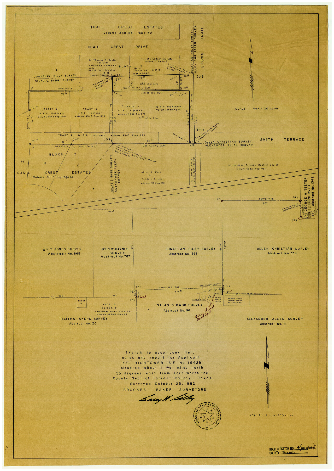
Tarrant County Rolled Sketch 4
Sketch to accompany field notes and report for applicant R.C. Hightower, SF-16429
-
Map/Doc
7912
-
Collection
General Map Collection
-
Object Dates
10/25/1982 (Creation Date)
2/10/1983 (File Date)
-
People and Organizations
Garey W. Gilley (Surveyor/Engineer)
-
Counties
Tarrant
-
Subjects
Surveying Rolled Sketch
-
Height x Width
27.2 x 19.2 inches
69.1 x 48.8 cm
-
Medium
blueprint/diazo
-
Scale
1" = 200 varas
Part of: General Map Collection
Gonzales County

Print $40.00
- Digital $50.00
Gonzales County
1986
Size 41.6 x 54.7 inches
Map/Doc 73160
San Saba County Sketch File 7

Print $22.00
- Digital $50.00
San Saba County Sketch File 7
1883
Size 8.6 x 7.8 inches
Map/Doc 36417
Flight Mission No. DAG-17K, Frame 76, Matagorda County

Print $20.00
- Digital $50.00
Flight Mission No. DAG-17K, Frame 76, Matagorda County
1952
Size 16.6 x 16.6 inches
Map/Doc 86335
Brewster County Rolled Sketch 101

Print $40.00
- Digital $50.00
Brewster County Rolled Sketch 101
1927
Size 63.0 x 46.2 inches
Map/Doc 10648
Navarro County Boundary File 1

Print $66.00
- Digital $50.00
Navarro County Boundary File 1
Size 10.3 x 8.2 inches
Map/Doc 57582
Crockett County Rolled Sketch 97

Print $20.00
- Digital $50.00
Crockett County Rolled Sketch 97
2013
Size 22.9 x 24.8 inches
Map/Doc 93664
Dimmit County Sketch File 24

Print $4.00
- Digital $50.00
Dimmit County Sketch File 24
1885
Size 13.0 x 8.7 inches
Map/Doc 21140
Briscoe County Sketch File H-1

Print $40.00
- Digital $50.00
Briscoe County Sketch File H-1
Size 21.7 x 18.2 inches
Map/Doc 11006
Culberson County Working Sketch 89

Print $20.00
- Digital $50.00
Culberson County Working Sketch 89
1984
Size 34.6 x 30.0 inches
Map/Doc 68543
Brown County Sketch File 26

Print $40.00
- Digital $50.00
Brown County Sketch File 26
Size 18.4 x 24.4 inches
Map/Doc 11023
Go Turnpike! Dallas-Fort Worth Turnpike (Recto)

Go Turnpike! Dallas-Fort Worth Turnpike (Recto)
1963
Size 11.2 x 17.2 inches
Map/Doc 94177
Flight Mission No. CUG-1P, Frame 74, Kleberg County

Print $20.00
- Digital $50.00
Flight Mission No. CUG-1P, Frame 74, Kleberg County
1956
Size 18.5 x 22.3 inches
Map/Doc 86139
You may also like
Nueces County Rolled Sketch 10

Print $40.00
- Digital $50.00
Nueces County Rolled Sketch 10
Size 31.6 x 55.4 inches
Map/Doc 8350
General Highway Map, Van Zandt County, Texas

Print $20.00
General Highway Map, Van Zandt County, Texas
1936
Size 18.2 x 25.1 inches
Map/Doc 79267

Flight Mission No. DAG-24K, Frame 153, Matagorda County

Print $20.00
- Digital $50.00
Flight Mission No. DAG-24K, Frame 153, Matagorda County
1953
Size 17.3 x 18.8 inches
Map/Doc 86567
Crane County Sketch File 23a

Print $6.00
- Digital $50.00
Crane County Sketch File 23a
1931
Size 14.4 x 8.9 inches
Map/Doc 19593
Texas Gulf Coast, from the Sabine River to the Rio Grande as Subdivided for Mineral Development; Galveston, Brazoria and Matagorda Counties

Print $40.00
- Digital $50.00
Texas Gulf Coast, from the Sabine River to the Rio Grande as Subdivided for Mineral Development; Galveston, Brazoria and Matagorda Counties
1976
Size 43.8 x 69.3 inches
Map/Doc 1938
Medina County Working Sketch 21

Print $20.00
- Digital $50.00
Medina County Working Sketch 21
1982
Size 18.1 x 23.3 inches
Map/Doc 70936
Crockett County Sketch File 89

Print $40.00
- Digital $50.00
Crockett County Sketch File 89
1958
Size 12.7 x 13.5 inches
Map/Doc 19916
Harris County Working Sketch 66

Print $40.00
- Digital $50.00
Harris County Working Sketch 66
1955
Size 33.7 x 49.7 inches
Map/Doc 65958
Bailey County Sketch File 10

Print $4.00
- Digital $50.00
Bailey County Sketch File 10
Size 14.1 x 8.7 inches
Map/Doc 13965
Erath County Sketch File 2

Print $20.00
- Digital $50.00
Erath County Sketch File 2
Size 13.2 x 15.5 inches
Map/Doc 11463
[Littlefield Subdivision Blocks 657-687]
![91009, [Littlefield Subdivision Blocks 657-687], Twichell Survey Records](https://historictexasmaps.com/wmedia_w700/maps/91009-1.tif.jpg)
Print $20.00
- Digital $50.00
[Littlefield Subdivision Blocks 657-687]
Size 31.2 x 20.5 inches
Map/Doc 91009