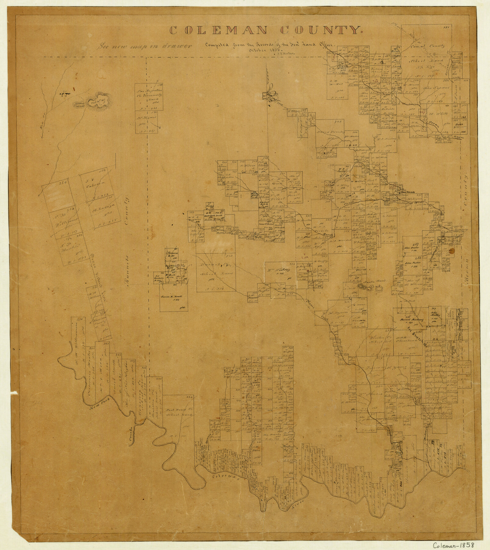
Coleman County
-
Map/Doc
3409
-
Collection
General Map Collection
-
Object Dates
10/1858 (Creation Date)
-
People and Organizations
James P. Hector (Compiler)
-
Counties
Coleman
-
Subjects
County
-
Height x Width
25.2 x 22.5 inches
64.0 x 57.2 cm
-
Features
Jim Neds [sic] Creek
Colorado River
Concho [River]
Urania Creek
Davids Creek
Mukewater Creek
Red Fork [of Colorado River]
Home Creek
Santa Anna's Peak
Cunningham's Creek
Hord's Creek
Phantom Hill to Fort Croghan Road
Camp Colorado
Hog Creek
Twitty Creek
Rod Creek
Pecan Bayou
Table Mountain
Greenbrier Creek
Fort Croghan Road
Phantom Hill Road
Part of: General Map Collection
Lavaca County Working Sketch 4

Print $20.00
- Digital $50.00
Lavaca County Working Sketch 4
1938
Size 27.7 x 42.4 inches
Map/Doc 70357
Grayson County Boundary File 1

Print $24.00
- Digital $50.00
Grayson County Boundary File 1
Size 12.8 x 8.2 inches
Map/Doc 53916
King County Working Sketch 17

Print $40.00
- Digital $50.00
King County Working Sketch 17
1979
Size 32.2 x 59.3 inches
Map/Doc 70181
Map of Comanche County

Print $20.00
- Digital $50.00
Map of Comanche County
1884
Size 20.9 x 26.5 inches
Map/Doc 3434
Dawson County Sketch File 8

Print $12.00
- Digital $50.00
Dawson County Sketch File 8
1924
Size 11.3 x 9.0 inches
Map/Doc 20536
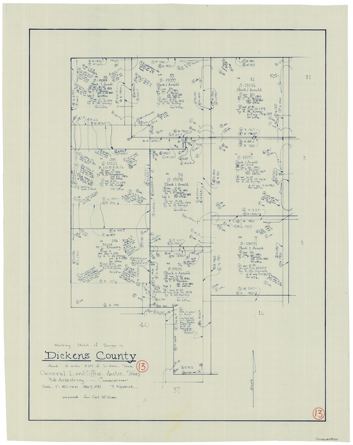
Dickens County Working Sketch 13
Print $20.00
- Digital $50.00
Dickens County Working Sketch 13
1981
Size 26.8 x 21.4 inches
Map/Doc 68661
Mason County Sketch File 21

Print $6.00
- Digital $50.00
Mason County Sketch File 21
Size 15.7 x 10.9 inches
Map/Doc 30717
Caldwell County

Print $20.00
- Digital $50.00
Caldwell County
1935
Size 38.7 x 42.7 inches
Map/Doc 95444
Polk County Sketch File 2a

Print $4.00
- Digital $50.00
Polk County Sketch File 2a
1863
Size 12.2 x 8.1 inches
Map/Doc 34120
Val Verde County Working Sketch 89

Print $20.00
- Digital $50.00
Val Verde County Working Sketch 89
1974
Size 24.5 x 29.0 inches
Map/Doc 72224
Erath County Working Sketch 27

Print $20.00
- Digital $50.00
Erath County Working Sketch 27
1970
Size 26.6 x 24.0 inches
Map/Doc 69108
Fractional Township No. 9 South Range No. 23 East of the Indian Meridian, Indian Territory

Print $20.00
- Digital $50.00
Fractional Township No. 9 South Range No. 23 East of the Indian Meridian, Indian Territory
1898
Size 19.2 x 24.4 inches
Map/Doc 75240
You may also like
Coast of Texas Between Brazos River and Matagorda Bay

Print $40.00
- Digital $50.00
Coast of Texas Between Brazos River and Matagorda Bay
1853
Size 32.6 x 72.1 inches
Map/Doc 69977
Presidio County Rolled Sketch 43

Print $20.00
- Digital $50.00
Presidio County Rolled Sketch 43
1907
Size 31.5 x 19.7 inches
Map/Doc 7340
Zapata County Sketch File 20

Print $633.00
- Digital $50.00
Zapata County Sketch File 20
1998
Size 11.5 x 8.9 inches
Map/Doc 40966
Terrell County Rolled Sketch 53A

Print $20.00
- Digital $50.00
Terrell County Rolled Sketch 53A
Size 32.9 x 24.2 inches
Map/Doc 7972
Martin County Boundary File 2

Print $32.00
- Digital $50.00
Martin County Boundary File 2
Size 9.3 x 9.1 inches
Map/Doc 56760
Hale County Sketch File 4

Print $20.00
- Digital $50.00
Hale County Sketch File 4
1891
Size 18.8 x 16.4 inches
Map/Doc 11594
Flight Mission No. CRC-2R, Frame 190, Chambers County

Print $20.00
- Digital $50.00
Flight Mission No. CRC-2R, Frame 190, Chambers County
1956
Size 18.8 x 22.4 inches
Map/Doc 84768
Map of the River Sabine from Logan's Ferry to 32nd degree of North Latitude

Print $20.00
- Digital $50.00
Map of the River Sabine from Logan's Ferry to 32nd degree of North Latitude
Size 22.1 x 28.6 inches
Map/Doc 94002
Lamb County Rolled Sketch 5

Print $20.00
- Digital $50.00
Lamb County Rolled Sketch 5
Size 11.8 x 21.5 inches
Map/Doc 6563

Hardeman County Sketch File A3

Print $4.00
- Digital $50.00
Hardeman County Sketch File A3
1890
Size 14.2 x 8.8 inches
Map/Doc 25052
Maverick County Working Sketch 5

Print $40.00
- Digital $50.00
Maverick County Working Sketch 5
1944
Size 55.4 x 43.0 inches
Map/Doc 70897