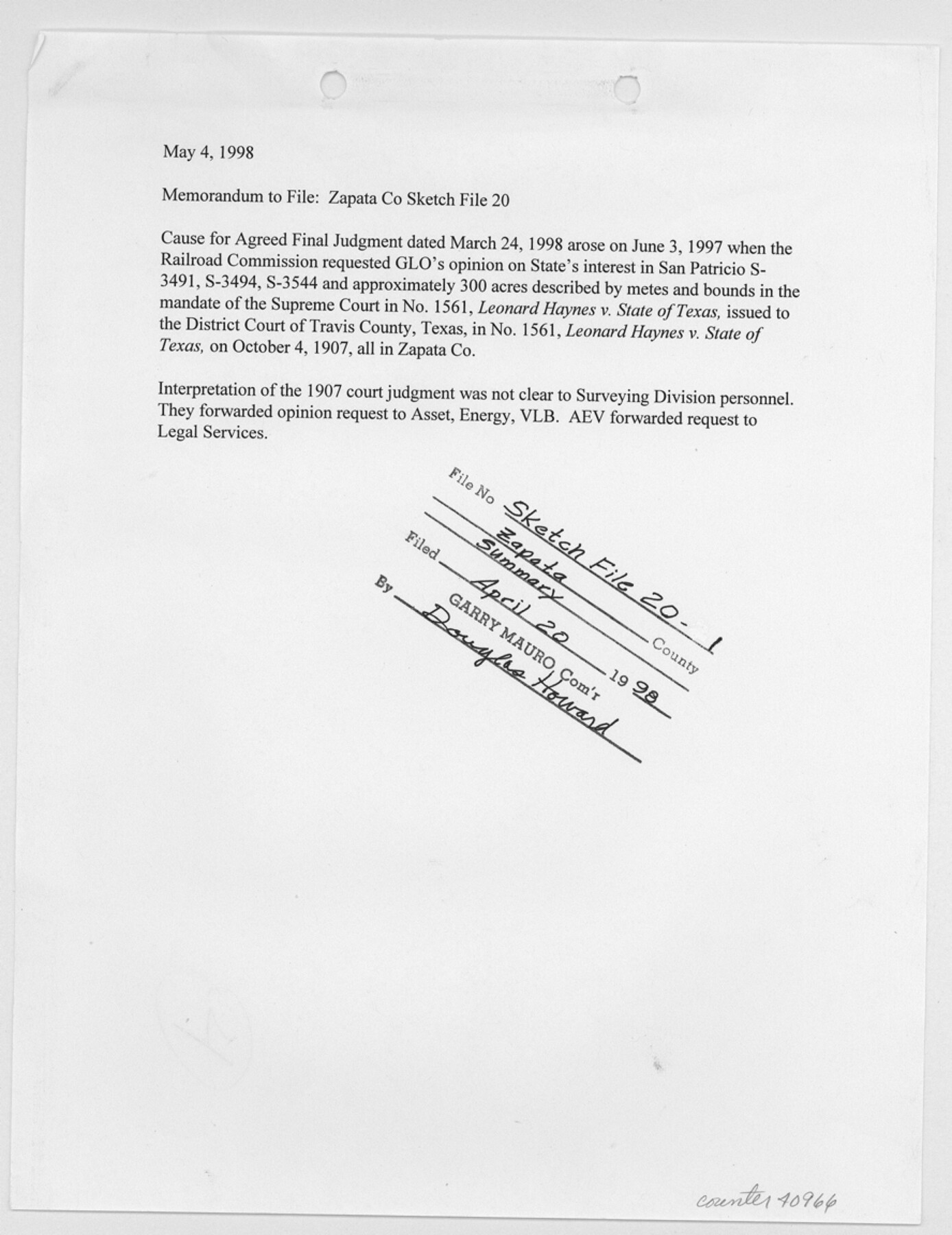
Zapata County Sketch File 20
[Agreed final judgement no. 97-12885, William Herbert Hunt Trust Estate vs. Garry Mauro and related documents]
-
Map/Doc
40966
-
Collection
General Map Collection
-
Object Dates
1998-2003 (Creation Date)
-
People and Organizations
Cesaro de los Santos (Chainman/Field Personnel)
Martin Van Merrick (Chainman/Field Personnel)
Fernando Uribe (Surveyor/Engineer)
Antonio Canales (Surveyor/Engineer)
Felix A. Blucher (Surveyor/Engineer)
Antonio Gonzales (Surveyor/Engineer)
Thomas Cuellar (Chainman/Field Personnel)
Leonard Haynes (Surveyor/Engineer)
James McLain (Chainman/Field Personnel)
LaNell Aston (GLO Clerk)
Jerry Patterson (GLO Commissioner)
-
Counties
Zapata
-
Subjects
Surveying Sketch File
-
Height x Width
11.5 x 8.9 inches
29.2 x 22.6 cm
-
Medium
multi-page, multi-format
-
Features
Ovejas Ranch
Road from the Alberca to the Angelos
Road from the Alberca to the Ojuelas and Laredo
Dolores
San Antonio
Bejar
Nueces River
Medina River
Guerrero
Road to Tepocan
San Bartolo and Ovejas Road
Carrizo and Venados Road
Arroyo Blanco
Carrizo
Road to Tanque
Arroyo de Simon
Rio Grande
Rio Grande City to Laredo Road
Part of: General Map Collection
El Paso County Rolled Sketch 30

Print $20.00
- Digital $50.00
El Paso County Rolled Sketch 30
1906
Size 40.9 x 22.8 inches
Map/Doc 5825
Crosby County Working Sketch 12

Print $20.00
- Digital $50.00
Crosby County Working Sketch 12
1953
Size 26.0 x 29.8 inches
Map/Doc 68446
Caldwell County Sketch File 2

Print $40.00
- Digital $50.00
Caldwell County Sketch File 2
1877
Size 12.9 x 20.0 inches
Map/Doc 11030
Val Verde County Sketch File Z20

Print $20.00
- Digital $50.00
Val Verde County Sketch File Z20
1913
Size 11.5 x 9.0 inches
Map/Doc 39153
Maps of Gulf Intracoastal Waterway, Texas - Sabine River to the Rio Grande and connecting waterways including ship channels

Print $20.00
- Digital $50.00
Maps of Gulf Intracoastal Waterway, Texas - Sabine River to the Rio Grande and connecting waterways including ship channels
1966
Size 15.6 x 22.0 inches
Map/Doc 61984
Jack County Sketch File 2

Print $6.00
- Digital $50.00
Jack County Sketch File 2
1856
Size 8.8 x 8.0 inches
Map/Doc 27501
Flight Mission No. BRA-7M, Frame 86, Jefferson County

Print $20.00
- Digital $50.00
Flight Mission No. BRA-7M, Frame 86, Jefferson County
1953
Size 18.7 x 22.4 inches
Map/Doc 85508
Cottle County Rolled Sketch 14

Print $741.00
- Digital $50.00
Cottle County Rolled Sketch 14
1882
Size 10.8 x 16.0 inches
Map/Doc 42369
Medina County Sketch File 15

Print $6.00
- Digital $50.00
Medina County Sketch File 15
1943
Size 14.2 x 8.5 inches
Map/Doc 31473
Potter County Sketch File 20

Print $4.00
- Digital $50.00
Potter County Sketch File 20
Size 12.2 x 8.7 inches
Map/Doc 34411
Harris County Working Sketch 51

Print $20.00
- Digital $50.00
Harris County Working Sketch 51
1947
Size 39.6 x 36.6 inches
Map/Doc 65943
Potter County Working Sketch 13

Print $20.00
- Digital $50.00
Potter County Working Sketch 13
1980
Size 19.5 x 26.9 inches
Map/Doc 71673
You may also like
Gregg County Sketch File 14

Print $6.00
- Digital $50.00
Gregg County Sketch File 14
1946
Size 14.3 x 8.8 inches
Map/Doc 24613
Map of Nacogdoches County

Print $20.00
- Digital $50.00
Map of Nacogdoches County
1881
Size 23.7 x 21.0 inches
Map/Doc 4599
Zapata County Working Sketch 15

Print $20.00
- Digital $50.00
Zapata County Working Sketch 15
1969
Size 38.2 x 38.7 inches
Map/Doc 62066
Flight Mission No. CGI-1N, Frame 137, Cameron County

Print $20.00
- Digital $50.00
Flight Mission No. CGI-1N, Frame 137, Cameron County
1955
Size 15.5 x 18.8 inches
Map/Doc 84493
Comanche County

Print $20.00
- Digital $50.00
Comanche County
1896
Size 40.5 x 45.1 inches
Map/Doc 66783
Fort Bend County State Real Property Sketch 10

Print $40.00
- Digital $50.00
Fort Bend County State Real Property Sketch 10
1985
Size 43.4 x 34.7 inches
Map/Doc 61684
Drainage Basins of Texas Streams

Print $20.00
- Digital $50.00
Drainage Basins of Texas Streams
Size 35.3 x 42.0 inches
Map/Doc 65270
Donley County Sketch File 18 (2a)

Print $2.00
- Digital $50.00
Donley County Sketch File 18 (2a)
Size 10.3 x 8.0 inches
Map/Doc 21255
Travis County Working Sketch 64

Print $20.00
- Digital $50.00
Travis County Working Sketch 64
2000
Size 16.8 x 19.6 inches
Map/Doc 69448
Subdivision Plat of Blue Ridge State Farm Showing 18 Tracts

Print $20.00
- Digital $50.00
Subdivision Plat of Blue Ridge State Farm Showing 18 Tracts
Size 27.0 x 27.4 inches
Map/Doc 62978
Chambers County Working Sketch 7

Print $20.00
- Digital $50.00
Chambers County Working Sketch 7
1939
Size 30.6 x 39.6 inches
Map/Doc 67990
La Salle County Working Sketch 53

Print $20.00
- Digital $50.00
La Salle County Working Sketch 53
Size 14.3 x 15.9 inches
Map/Doc 67362