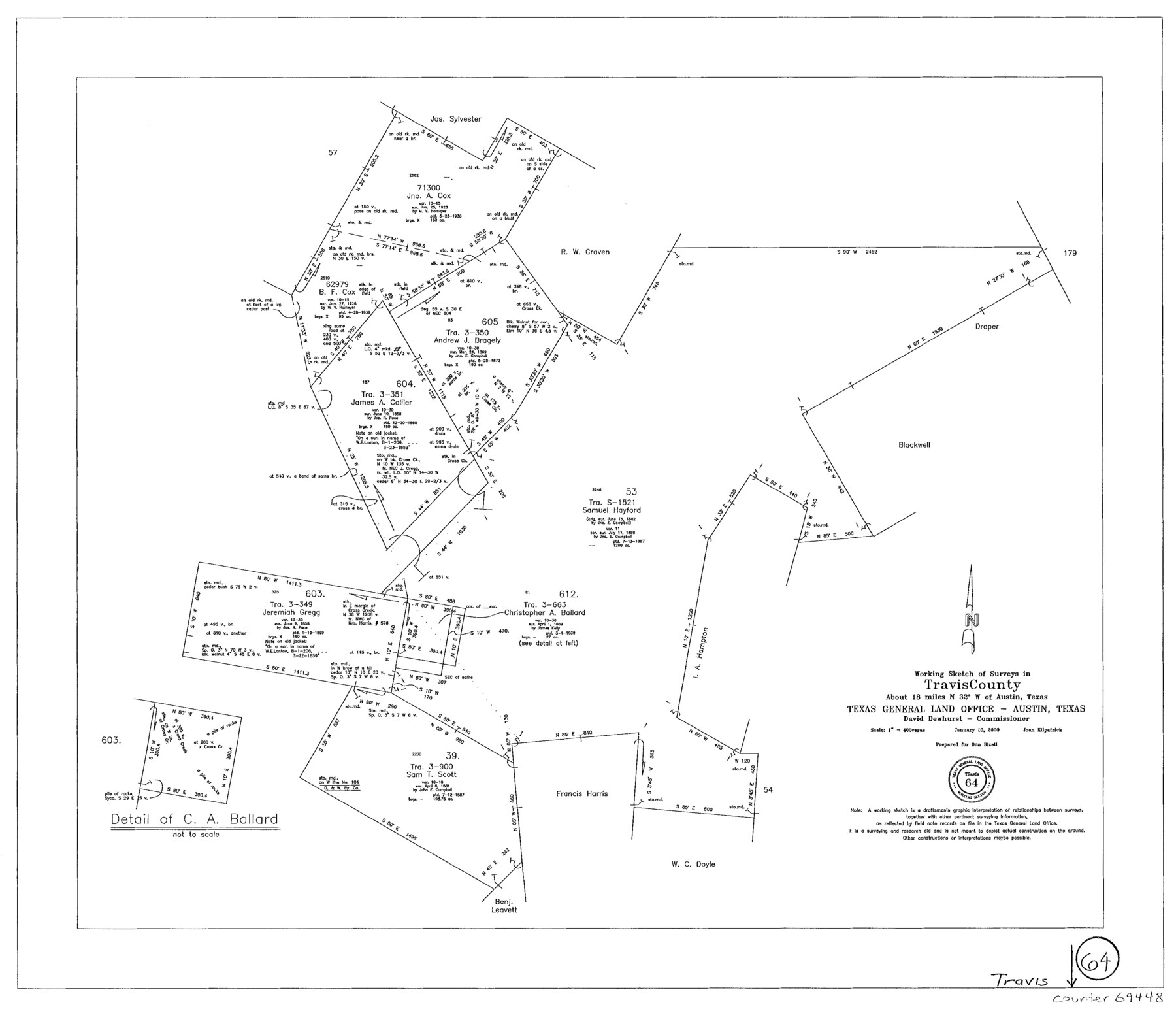
Travis County Working Sketch 64
-
Map/Doc
69448
-
Collection
General Map Collection
-
Object Dates
1/10/2000 (Creation Date)
-
People and Organizations
Joan Kilpatrick (Draftsman)
-
Counties
Travis
-
Subjects
Surveying Working Sketch
-
Height x Width
16.8 x 19.6 inches
42.7 x 49.8 cm
-
Scale
1" = 400 varas
Part of: General Map Collection
Flight Mission No. DQN-3K, Frame 74, Calhoun County

Print $20.00
- Digital $50.00
Flight Mission No. DQN-3K, Frame 74, Calhoun County
1953
Size 16.2 x 16.1 inches
Map/Doc 84365
Flight Mission No. CRC-2R, Frame 132, Chambers County

Print $20.00
- Digital $50.00
Flight Mission No. CRC-2R, Frame 132, Chambers County
1956
Size 18.6 x 22.3 inches
Map/Doc 84748
Tom Green County Rolled Sketch 4

Print $20.00
- Digital $50.00
Tom Green County Rolled Sketch 4
Size 28.2 x 23.6 inches
Map/Doc 7994
Aransas Pass to Baffin Bay

Print $20.00
- Digital $50.00
Aransas Pass to Baffin Bay
1961
Size 42.1 x 35.4 inches
Map/Doc 73414
St. L. S-W. Ry. of Texas Map of Hillsboro Branch in Navarro County, Texas M.P. 621 to M.P. 648

Print $40.00
- Digital $50.00
St. L. S-W. Ry. of Texas Map of Hillsboro Branch in Navarro County, Texas M.P. 621 to M.P. 648
1913
Size 28.0 x 431.2 inches
Map/Doc 94016
Cooke County Working Sketch 17

Print $20.00
- Digital $50.00
Cooke County Working Sketch 17
1950
Size 24.7 x 17.8 inches
Map/Doc 68254
[Subdivision of Nueces Bay and list of Court Decrees]
![2086, [Subdivision of Nueces Bay and list of Court Decrees], General Map Collection](https://historictexasmaps.com/wmedia_w700/maps/2086-1.tif.jpg)
Print $40.00
- Digital $50.00
[Subdivision of Nueces Bay and list of Court Decrees]
1940
Size 34.2 x 48.8 inches
Map/Doc 2086
Goliad County Working Sketch 19

Print $20.00
- Digital $50.00
Goliad County Working Sketch 19
1954
Size 31.5 x 31.8 inches
Map/Doc 63209
Calhoun County Working Sketch Graphic Index

Print $40.00
- Digital $50.00
Calhoun County Working Sketch Graphic Index
1948
Size 48.2 x 40.1 inches
Map/Doc 76484
Morris County Rolled Sketch 2A

Print $20.00
- Digital $50.00
Morris County Rolled Sketch 2A
Size 36.5 x 20.0 inches
Map/Doc 10283
Westliches - Nordamerica

Print $20.00
- Digital $50.00
Westliches - Nordamerica
1867
Size 25.3 x 20.7 inches
Map/Doc 93753
Frio County Rolled Sketch 26

Print $20.00
- Digital $50.00
Frio County Rolled Sketch 26
1994
Size 28.1 x 38.9 inches
Map/Doc 5926
You may also like
Jefferson County Rolled Sketch 44

Print $20.00
- Digital $50.00
Jefferson County Rolled Sketch 44
1957
Size 26.9 x 25.5 inches
Map/Doc 6401
Crane County Sketch File 13b

Print $40.00
- Digital $50.00
Crane County Sketch File 13b
1901
Size 11.4 x 13.8 inches
Map/Doc 19573
Presidio County Rolled Sketch A-1

Print $20.00
- Digital $50.00
Presidio County Rolled Sketch A-1
1889
Size 26.8 x 32.0 inches
Map/Doc 9769
[Texas Gulf Coast from Rio Grande to Sabine Lake]
![72686, [Texas Gulf Coast from Rio Grande to Sabine Lake], General Map Collection](https://historictexasmaps.com/wmedia_w700/maps/72686.tif.jpg)
Print $20.00
- Digital $50.00
[Texas Gulf Coast from Rio Grande to Sabine Lake]
Size 28.0 x 18.3 inches
Map/Doc 72686
Harris County Working Sketch 19

Print $40.00
- Digital $50.00
Harris County Working Sketch 19
1921
Size 42.5 x 55.0 inches
Map/Doc 65911
Pecos County Working Sketch 66

Print $20.00
- Digital $50.00
Pecos County Working Sketch 66
1955
Size 25.8 x 21.2 inches
Map/Doc 71538
Crockett County Sketch File 38

Print $20.00
- Digital $50.00
Crockett County Sketch File 38
1887
Size 20.8 x 30.3 inches
Map/Doc 11220
Shelby County Sketch File 14

Print $4.00
- Digital $50.00
Shelby County Sketch File 14
1872
Size 9.8 x 8.9 inches
Map/Doc 36622
Glasscock County Sketch File 2

Print $20.00
- Digital $50.00
Glasscock County Sketch File 2
1931
Size 35.1 x 16.2 inches
Map/Doc 11559
Culberson County Working Sketch 55

Print $20.00
- Digital $50.00
Culberson County Working Sketch 55
1974
Size 47.1 x 33.7 inches
Map/Doc 68509
Leon County Sketch File 35-1

Print $28.00
- Digital $50.00
Leon County Sketch File 35-1
1966
Size 14.1 x 8.6 inches
Map/Doc 29836
Eastland County Rolled Sketch 14

Print $20.00
- Digital $50.00
Eastland County Rolled Sketch 14
Size 18.5 x 18.3 inches
Map/Doc 5775