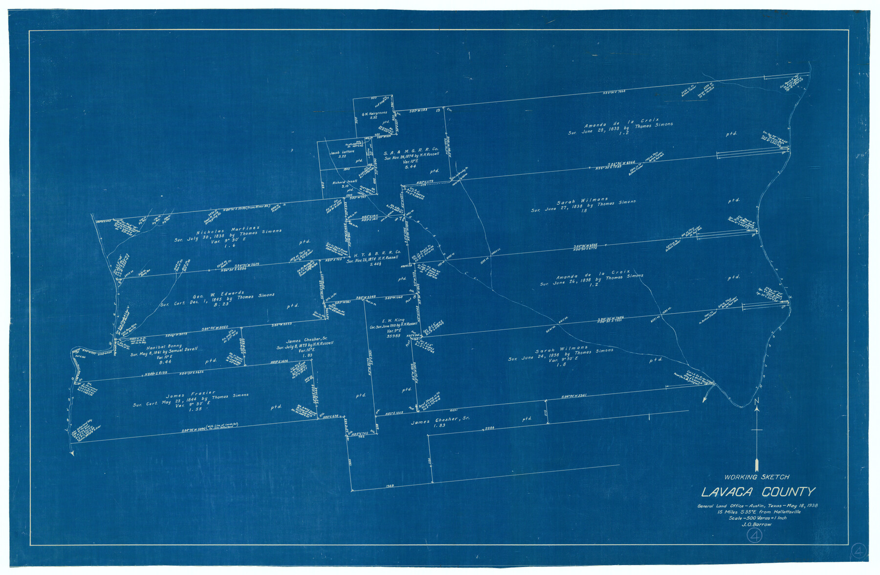
Lavaca County Working Sketch 4
-
Map/Doc
70357
-
Collection
General Map Collection
-
Object Dates
5/18/1938 (Creation Date)
-
People and Organizations
J.O. Barrow (Draftsman)
-
Counties
Lavaca
-
Subjects
Surveying Working Sketch
-
Height x Width
27.7 x 42.4 inches
70.4 x 107.7 cm
-
Scale
1" = 500 varas
Part of: General Map Collection
Map of Runnels County

Print $20.00
- Digital $50.00
Map of Runnels County
1858
Size 24.7 x 25.6 inches
Map/Doc 4004
Colorado County Sketch File 33

Print $44.00
- Digital $50.00
Colorado County Sketch File 33
1847
Size 13.2 x 16.2 inches
Map/Doc 18988
Stonewall County Sketch File 18-1

Print $8.00
- Digital $50.00
Stonewall County Sketch File 18-1
1905
Size 11.3 x 8.6 inches
Map/Doc 37284
Flight Mission No. BQR-13K, Frame 24, Brazoria County

Print $20.00
- Digital $50.00
Flight Mission No. BQR-13K, Frame 24, Brazoria County
1952
Size 18.9 x 22.4 inches
Map/Doc 84072
[G. C. & S. F. Ry., San Saba Branch, Right of Way Map, Brady to Melvin]
![61421, [G. C. & S. F. Ry., San Saba Branch, Right of Way Map, Brady to Melvin], General Map Collection](https://historictexasmaps.com/wmedia_w700/maps/61421.tif.jpg)
Print $40.00
- Digital $50.00
[G. C. & S. F. Ry., San Saba Branch, Right of Way Map, Brady to Melvin]
1916
Size 37.7 x 121.5 inches
Map/Doc 61421
Uvalde County Rolled Sketch 7

Print $20.00
- Digital $50.00
Uvalde County Rolled Sketch 7
1946
Size 23.8 x 15.7 inches
Map/Doc 8092
Austin County Sketch File 10

Print $40.00
- Digital $50.00
Austin County Sketch File 10
1895
Size 25.5 x 21.0 inches
Map/Doc 10875
Plat of Resurvey of Sections 5, 7 and 8, T. 5S., R. 14W. Indian Meridian, Oklahoma

Print $4.00
- Digital $50.00
Plat of Resurvey of Sections 5, 7 and 8, T. 5S., R. 14W. Indian Meridian, Oklahoma
1917
Size 18.5 x 22.6 inches
Map/Doc 75140
Andrews County Rolled Sketch 23

Print $40.00
- Digital $50.00
Andrews County Rolled Sketch 23
1946
Size 78.0 x 13.7 inches
Map/Doc 8396
Montague County Working Sketch 40

Print $20.00
- Digital $50.00
Montague County Working Sketch 40
1995
Size 20.6 x 17.5 inches
Map/Doc 71106
[Surveys along the Red River, Bois d'Arc Creek, Duck Creek, and Choctaw Bayou made under G.W. Smyth, Commissioner]
![74, [Surveys along the Red River, Bois d'Arc Creek, Duck Creek, and Choctaw Bayou made under G.W. Smyth, Commissioner], General Map Collection](https://historictexasmaps.com/wmedia_w700/maps/74.tif.jpg)
Print $20.00
- Digital $50.00
[Surveys along the Red River, Bois d'Arc Creek, Duck Creek, and Choctaw Bayou made under G.W. Smyth, Commissioner]
1834
Size 19.7 x 16.0 inches
Map/Doc 74
Wichita County

Print $20.00
- Digital $50.00
Wichita County
1971
Size 38.1 x 39.8 inches
Map/Doc 73323
You may also like
Terrell County Working Sketch 80

Print $20.00
- Digital $50.00
Terrell County Working Sketch 80
1985
Size 20.7 x 36.4 inches
Map/Doc 69601
Parmer County Sketch File 2

Print $26.00
- Digital $50.00
Parmer County Sketch File 2
1903
Size 7.2 x 8.7 inches
Map/Doc 33626
DeWitt County Working Sketch 4

Print $20.00
- Digital $50.00
DeWitt County Working Sketch 4
1963
Size 37.0 x 45.6 inches
Map/Doc 68594
Williamson County Rolled Sketch 7

Print $40.00
- Digital $50.00
Williamson County Rolled Sketch 7
1924
Size 38.4 x 54.5 inches
Map/Doc 10146
Map of the upper surveys in Robertson's Colony Sold by the State of Coahuila and Texas

Print $20.00
- Digital $50.00
Map of the upper surveys in Robertson's Colony Sold by the State of Coahuila and Texas
Size 26.8 x 22.0 inches
Map/Doc 82
Current Miscellaneous File 7

Print $6.00
- Digital $50.00
Current Miscellaneous File 7
1838
Size 13.8 x 8.5 inches
Map/Doc 73733
Coleman County Sketch File 43

Print $12.00
- Digital $50.00
Coleman County Sketch File 43
1892
Size 9.2 x 8.8 inches
Map/Doc 18775
Andrews County Rolled Sketch 9

Print $20.00
- Digital $50.00
Andrews County Rolled Sketch 9
1930
Size 25.3 x 43.6 inches
Map/Doc 77160
Castro County Rolled Sketch 11

Print $20.00
- Digital $50.00
Castro County Rolled Sketch 11
1940
Size 20.2 x 25.3 inches
Map/Doc 5420
Brazoria County Sketch File 40

Print $8.00
- Digital $50.00
Brazoria County Sketch File 40
1935
Size 14.3 x 8.9 inches
Map/Doc 15049
Sherman County Rolled Sketch 14

Print $20.00
- Digital $50.00
Sherman County Rolled Sketch 14
1975
Size 17.4 x 17.7 inches
Map/Doc 7795
Copy of Surveyor's Field Book, Morris Browning - In Blocks 7, 5 & 4, I&GNRRCo., Hutchinson and Carson Counties, Texas

Print $2.00
- Digital $50.00
Copy of Surveyor's Field Book, Morris Browning - In Blocks 7, 5 & 4, I&GNRRCo., Hutchinson and Carson Counties, Texas
1888
Size 6.9 x 8.8 inches
Map/Doc 62281