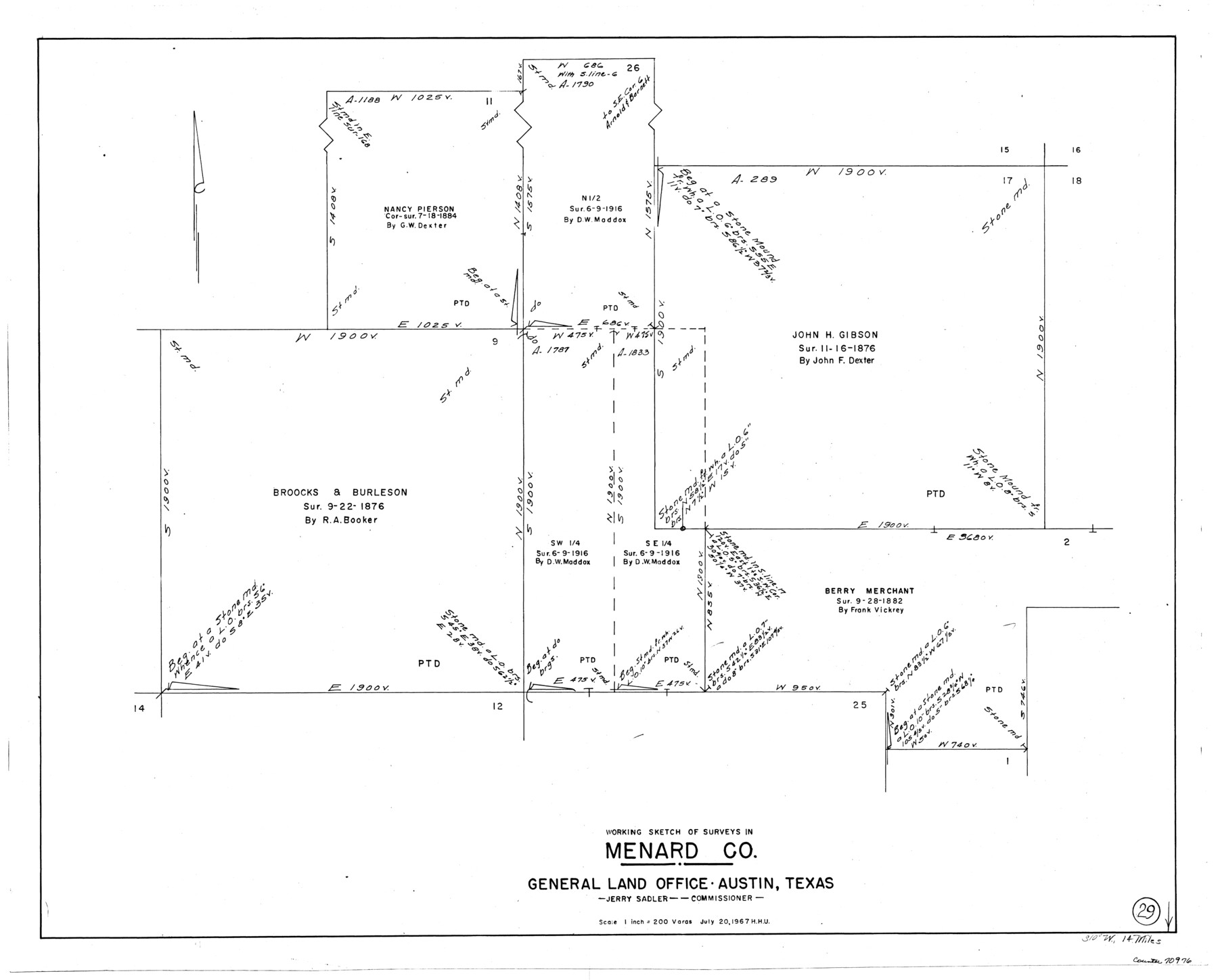
Menard County Working Sketch 29
-
Map/Doc
70976
-
Collection
General Map Collection
-
Object Dates
7/20/1967 (Creation Date)
-
People and Organizations
Herbert H. Ulbricht (Draftsman)
-
Counties
Menard
-
Subjects
Surveying Working Sketch
-
Height x Width
25.8 x 32.0 inches
65.5 x 81.3 cm
-
Scale
1" = 200 varas
Part of: General Map Collection
Morris County Rolled Sketch 2A

Print $20.00
- Digital $50.00
Morris County Rolled Sketch 2A
Size 24.0 x 18.7 inches
Map/Doc 10272
Johnson County Working Sketch 29

Print $20.00
- Digital $50.00
Johnson County Working Sketch 29
2006
Size 26.4 x 37.5 inches
Map/Doc 83060
Map of Orange County

Print $20.00
- Digital $50.00
Map of Orange County
1895
Size 15.5 x 16.2 inches
Map/Doc 3932
Pecos County Sketch File 94

Print $20.00
- Digital $50.00
Pecos County Sketch File 94
1956
Size 25.8 x 17.3 inches
Map/Doc 12185
Red River County Sketch File 4

Print $6.00
- Digital $50.00
Red River County Sketch File 4
Size 9.3 x 11.5 inches
Map/Doc 35100
Jim Hogg County Boundary File 1

Print $16.00
- Digital $50.00
Jim Hogg County Boundary File 1
Size 11.4 x 8.8 inches
Map/Doc 55519
Flight Mission No. BRA-16M, Frame 132, Jefferson County

Print $20.00
- Digital $50.00
Flight Mission No. BRA-16M, Frame 132, Jefferson County
1953
Size 18.6 x 22.3 inches
Map/Doc 85742
Nueces County Rolled Sketch 111

Print $20.00
- Digital $50.00
Nueces County Rolled Sketch 111
1991
Size 24.6 x 36.1 inches
Map/Doc 7119
Flight Mission No. BRE-1P, Frame 47, Nueces County

Print $20.00
- Digital $50.00
Flight Mission No. BRE-1P, Frame 47, Nueces County
1956
Size 18.4 x 22.3 inches
Map/Doc 86636
Map of Coryell County

Print $20.00
- Digital $50.00
Map of Coryell County
1874
Size 22.4 x 26.8 inches
Map/Doc 3445
Wichita County Working Sketch 14

Print $20.00
- Digital $50.00
Wichita County Working Sketch 14
1922
Size 20.8 x 42.1 inches
Map/Doc 72524
Flight Mission No. BQY-15M, Frame 15, Harris County

Print $20.00
- Digital $50.00
Flight Mission No. BQY-15M, Frame 15, Harris County
1953
Size 18.6 x 22.4 inches
Map/Doc 85313
You may also like
Live Oak County

Print $40.00
- Digital $50.00
Live Oak County
1899
Size 52.3 x 38.5 inches
Map/Doc 66905

[Resurvey of Block 1 - W. H. Godair]
![92898, [Resurvey of Block 1 - W. H. Godair], Twichell Survey Records](https://historictexasmaps.com/wmedia_w700/maps/92898-1.tif.jpg)
Print $20.00
- Digital $50.00
[Resurvey of Block 1 - W. H. Godair]
1923
Size 22.4 x 9.5 inches
Map/Doc 92898
Winkler County Working Sketch 20

Print $20.00
- Digital $50.00
Winkler County Working Sketch 20
1990
Size 22.3 x 24.0 inches
Map/Doc 72614
Flight Mission No. BQR-13K, Frame 27, Brazoria County

Print $20.00
- Digital $50.00
Flight Mission No. BQR-13K, Frame 27, Brazoria County
1952
Size 18.7 x 22.5 inches
Map/Doc 84075
Stephens County Working Sketch 33

Print $20.00
- Digital $50.00
Stephens County Working Sketch 33
1978
Size 31.1 x 30.8 inches
Map/Doc 63976
Sabine County Sketch File 7

Print $2.00
Sabine County Sketch File 7
1882
Size 8.6 x 12.7 inches
Map/Doc 35619
The Judicial District/County of Hamilton. Abolished, Spring 1842

Print $20.00
The Judicial District/County of Hamilton. Abolished, Spring 1842
2020
Size 14.9 x 21.7 inches
Map/Doc 96330
Newton County Working Sketch 38

Print $20.00
- Digital $50.00
Newton County Working Sketch 38
1961
Size 36.8 x 29.2 inches
Map/Doc 71284
Flight Mission No. BQR-9K, Frame 44, Brazoria County

Print $20.00
- Digital $50.00
Flight Mission No. BQR-9K, Frame 44, Brazoria County
1952
Size 18.7 x 22.3 inches
Map/Doc 84048
Coleman County Rolled Sketch 8

Print $40.00
- Digital $50.00
Coleman County Rolled Sketch 8
1951
Size 58.8 x 40.8 inches
Map/Doc 8634
Jack County Sketch File 14

Print $8.00
- Digital $50.00
Jack County Sketch File 14
1857
Size 10.0 x 5.7 inches
Map/Doc 27539