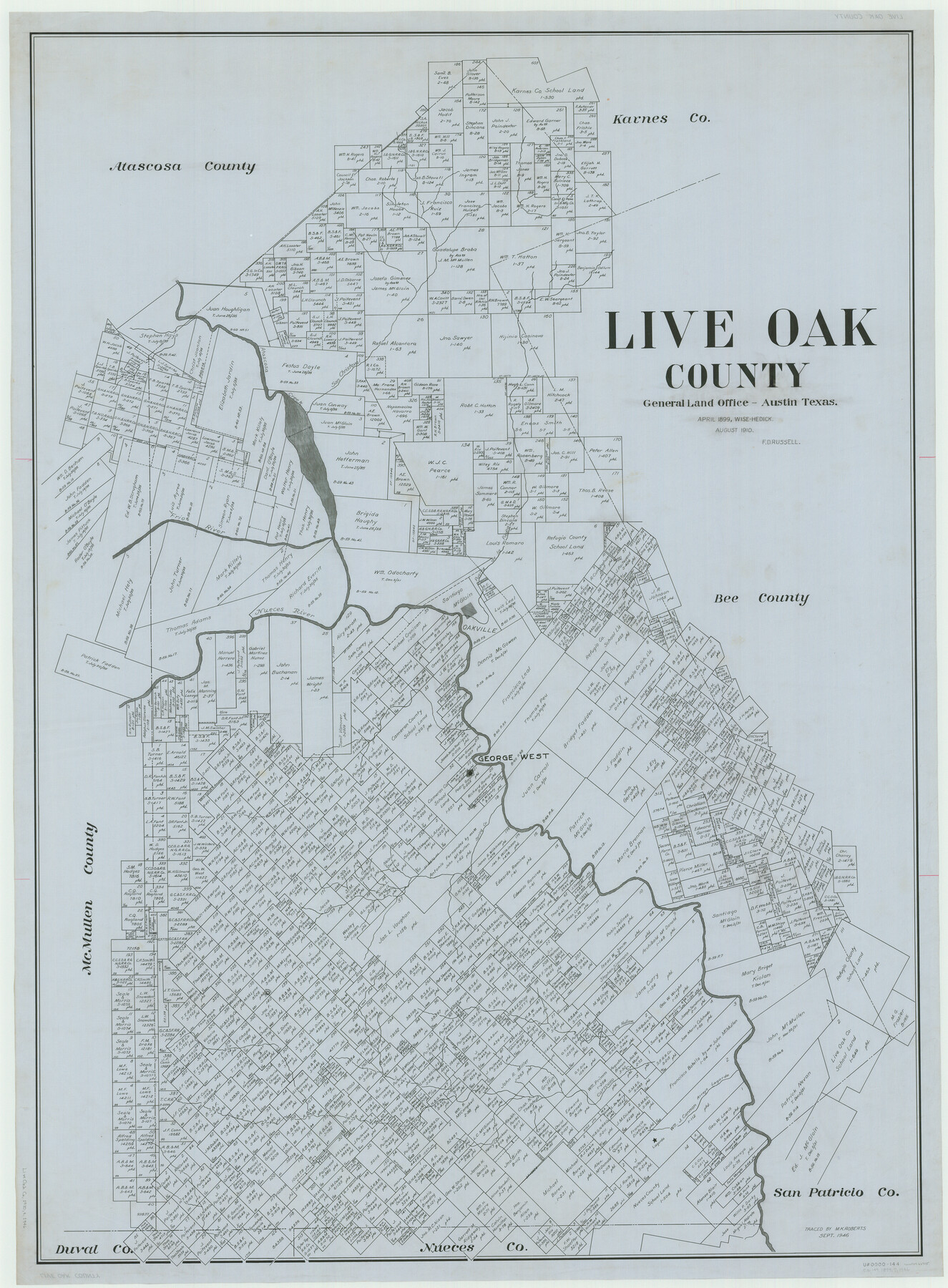
Live Oak County
-
Map/Doc
66905
-
Collection
General Map Collection
-
Object Dates
1899 (Creation Date)
-
People and Organizations
Texas General Land Office (Publisher)
Wise - Hedick (Draftsman)
Wise-Hedick (Compiler)
-
Counties
Live Oak
-
Subjects
County
-
Height x Width
52.3 x 38.5 inches
132.8 x 97.8 cm
-
Comments
Traced in August 1910 by F. D. Russell.
Traced in September 1946 by M. K. Roberts.
Part of: General Map Collection
Anderson County Sketch File 30

Print $4.00
- Digital $50.00
Anderson County Sketch File 30
1989
Size 11.3 x 8.6 inches
Map/Doc 12816
Kinney County Working Sketch 55

Print $20.00
- Digital $50.00
Kinney County Working Sketch 55
1982
Size 25.1 x 24.7 inches
Map/Doc 70237
Baylor County Boundary File 10

Print $38.00
- Digital $50.00
Baylor County Boundary File 10
Size 9.4 x 7.7 inches
Map/Doc 50409
Lavaca County Working Sketch 13

Print $20.00
- Digital $50.00
Lavaca County Working Sketch 13
1958
Size 23.5 x 29.1 inches
Map/Doc 70366
Childress County Sketch File 18a

Print $4.00
- Digital $50.00
Childress County Sketch File 18a
1935
Size 11.3 x 7.1 inches
Map/Doc 18364
Schleicher County Sketch File 5

Print $40.00
- Digital $50.00
Schleicher County Sketch File 5
Size 17.2 x 13.4 inches
Map/Doc 36470
Tom Green County Sketch File XXX

Print $20.00
- Digital $50.00
Tom Green County Sketch File XXX
Size 17.0 x 20.5 inches
Map/Doc 12457
The City of Austin and Suburbs

Print $40.00
- Digital $50.00
The City of Austin and Suburbs
1919
Size 120.7 x 43.9 inches
Map/Doc 88862
Trinity County Sketch File 34A

Print $6.00
- Digital $50.00
Trinity County Sketch File 34A
1921
Size 16.6 x 10.8 inches
Map/Doc 38578
Gaines County Working Sketch 12

Print $20.00
- Digital $50.00
Gaines County Working Sketch 12
1954
Size 27.1 x 37.0 inches
Map/Doc 69312
Flight Mission No. DCL-7C, Frame 37, Kenedy County

Print $20.00
- Digital $50.00
Flight Mission No. DCL-7C, Frame 37, Kenedy County
1943
Size 15.4 x 15.3 inches
Map/Doc 86025
Potter County Rolled Sketch 11

Print $20.00
- Digital $50.00
Potter County Rolled Sketch 11
1986
Size 21.6 x 27.4 inches
Map/Doc 7324
You may also like
Newton County Working Sketch 29

Print $20.00
- Digital $50.00
Newton County Working Sketch 29
1955
Size 21.2 x 39.8 inches
Map/Doc 71275
[Map showing Block 35, Townships 1N-5N]
![93207, [Map showing Block 35, Townships 1N-5N], Twichell Survey Records](https://historictexasmaps.com/wmedia_w700/maps/93207-1.tif.jpg)
Print $40.00
- Digital $50.00
[Map showing Block 35, Townships 1N-5N]
Size 22.8 x 83.0 inches
Map/Doc 93207
Anderson County Working Sketch 6

Print $20.00
- Digital $50.00
Anderson County Working Sketch 6
1913
Size 24.7 x 26.3 inches
Map/Doc 67005
Parker County

Print $20.00
- Digital $50.00
Parker County
1942
Size 42.4 x 35.5 inches
Map/Doc 77391
Crockett County Sketch File 43

Print $20.00
- Digital $50.00
Crockett County Sketch File 43
1880
Size 17.9 x 23.8 inches
Map/Doc 11223
Northeastern United States Including the Great Lakes Region

Northeastern United States Including the Great Lakes Region
1959
Size 25.6 x 19.3 inches
Map/Doc 92395
Sandhills Water Rights Survey, City of Lubbock, Texas

Print $40.00
- Digital $50.00
Sandhills Water Rights Survey, City of Lubbock, Texas
1957
Size 76.1 x 31.4 inches
Map/Doc 93211
Gregg County Rolled Sketch 20

Print $20.00
- Digital $50.00
Gregg County Rolled Sketch 20
1957
Size 34.0 x 44.4 inches
Map/Doc 9070
Garza County Sketch File 4a

Print $4.00
- Digital $50.00
Garza County Sketch File 4a
1883
Size 14.2 x 8.8 inches
Map/Doc 24048
Map of the Mercer Colony in Texas

Print $20.00
- Digital $50.00
Map of the Mercer Colony in Texas
1845
Size 17.1 x 10.6 inches
Map/Doc 87155
Map of the Oregon Territory by the U.S. Ex. Ex.

Print $20.00
- Digital $50.00
Map of the Oregon Territory by the U.S. Ex. Ex.
1841
Size 26.2 x 37.3 inches
Map/Doc 94060
Reconnoissances of Routes from San Antonio de Bexar to El Paso Del Norte

Print $20.00
Reconnoissances of Routes from San Antonio de Bexar to El Paso Del Norte
1849
Size 27.5 x 39.6 inches
Map/Doc 76239