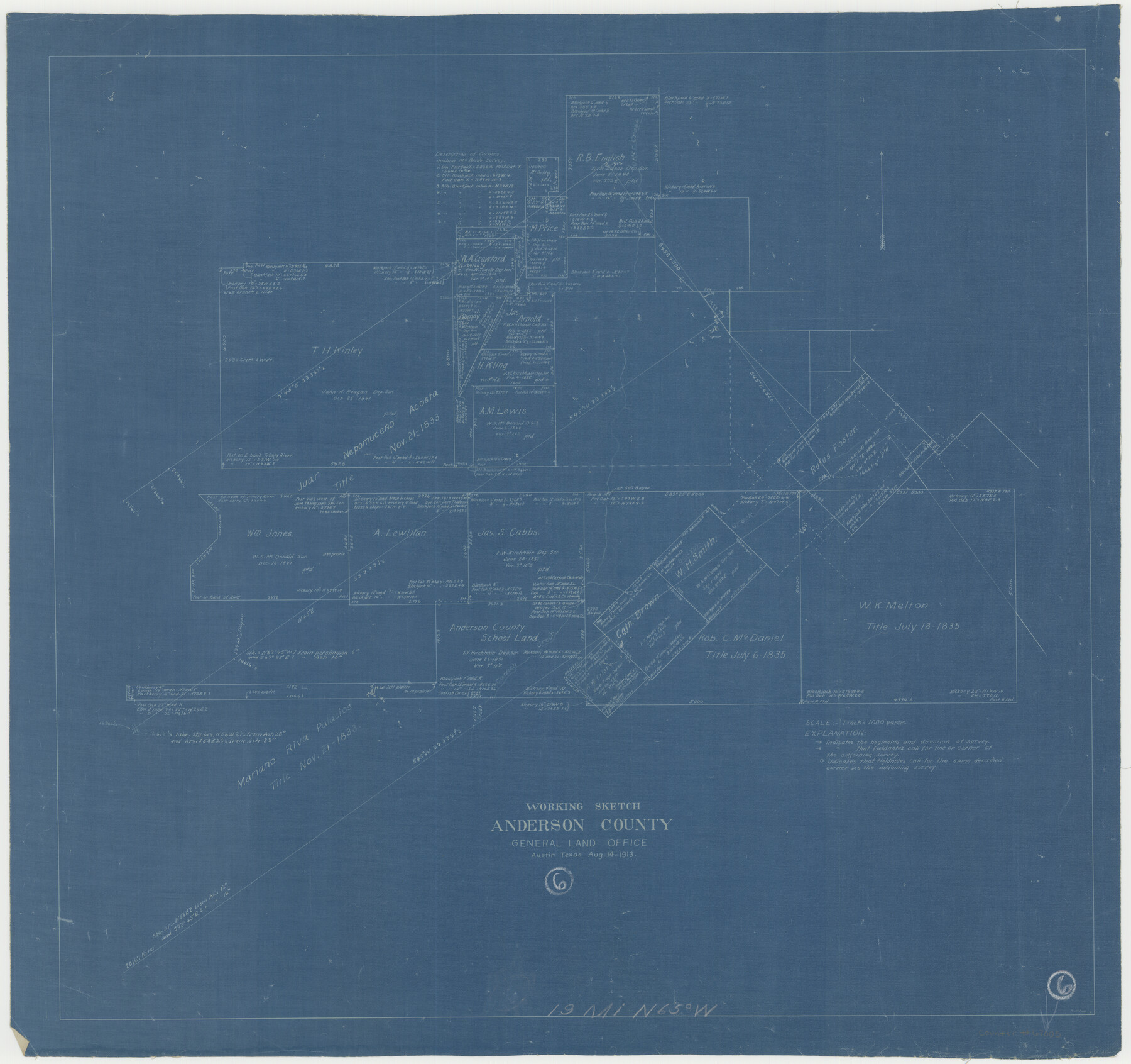
Anderson County Working Sketch 6
-
Map/Doc
67005
-
Collection
General Map Collection
-
Object Dates
8/14/1913 (Creation Date)
-
People and Organizations
John W. Pritchett (Draftsman)
-
Counties
Anderson
-
Subjects
Surveying Working Sketch
-
Height x Width
24.7 x 26.3 inches
62.7 x 66.8 cm
-
Scale
1" = 1000 varas
-
Comments
Surveys located about 19 miles North 65 degrees West of Palestine, Texas.
Part of: General Map Collection
Polk County Sketch File 21

Print $8.00
- Digital $50.00
Polk County Sketch File 21
Size 12.9 x 8.3 inches
Map/Doc 34169
Pecos County Rolled Sketch 122

Print $20.00
- Digital $50.00
Pecos County Rolled Sketch 122
1945
Size 32.5 x 39.1 inches
Map/Doc 7263
Presidio County Rolled Sketch 46

Print $20.00
- Digital $50.00
Presidio County Rolled Sketch 46
1908
Size 19.0 x 15.5 inches
Map/Doc 7342
Flight Mission No. CUG-1P, Frame 23, Kleberg County

Print $20.00
- Digital $50.00
Flight Mission No. CUG-1P, Frame 23, Kleberg County
1956
Size 18.5 x 22.1 inches
Map/Doc 86113
Flight Mission No. CGI-3N, Frame 171, Cameron County

Print $20.00
- Digital $50.00
Flight Mission No. CGI-3N, Frame 171, Cameron County
1954
Size 18.7 x 22.4 inches
Map/Doc 84635
Current Miscellaneous File 63

Print $6.00
- Digital $50.00
Current Miscellaneous File 63
1957
Size 14.1 x 8.8 inches
Map/Doc 74100
Palo Pinto County Working Sketch 1

Print $20.00
- Digital $50.00
Palo Pinto County Working Sketch 1
1903
Size 19.0 x 14.6 inches
Map/Doc 71384
Flight Mission No. DIX-10P, Frame 169, Aransas County

Print $20.00
- Digital $50.00
Flight Mission No. DIX-10P, Frame 169, Aransas County
1956
Size 18.7 x 22.3 inches
Map/Doc 83959
Flight Mission No. CGI-3N, Frame 123, Cameron County

Print $20.00
- Digital $50.00
Flight Mission No. CGI-3N, Frame 123, Cameron County
1954
Size 18.6 x 22.2 inches
Map/Doc 84596
[F. W. & D. C. Ry. Co. Alignment and Right of Way Map, Clay County]
![64725, [F. W. & D. C. Ry. Co. Alignment and Right of Way Map, Clay County], General Map Collection](https://historictexasmaps.com/wmedia_w700/maps/64725-1.tif.jpg)
Print $20.00
- Digital $50.00
[F. W. & D. C. Ry. Co. Alignment and Right of Way Map, Clay County]
1927
Size 18.6 x 11.7 inches
Map/Doc 64725
Val Verde County Working Sketch 72

Print $20.00
- Digital $50.00
Val Verde County Working Sketch 72
1967
Size 19.6 x 23.0 inches
Map/Doc 72207
Eastland County Working Sketch 60

Print $20.00
- Digital $50.00
Eastland County Working Sketch 60
1989
Size 25.5 x 19.5 inches
Map/Doc 68841
You may also like
Leon County Rolled Sketch 33

Print $20.00
- Digital $50.00
Leon County Rolled Sketch 33
1997
Size 26.3 x 36.7 inches
Map/Doc 6617
Upton County Rolled Sketch 33

Print $20.00
- Digital $50.00
Upton County Rolled Sketch 33
1951
Size 39.2 x 33.0 inches
Map/Doc 8076
Falls County Sketch File 21

Print $4.00
- Digital $50.00
Falls County Sketch File 21
1878
Size 8.7 x 9.0 inches
Map/Doc 22394
Map of the H.J. Dorrah survey 16 enlarged from the General Land Office map of the west part of Travis County, Texas

Print $2.00
- Digital $50.00
Map of the H.J. Dorrah survey 16 enlarged from the General Land Office map of the west part of Travis County, Texas
1920
Size 11.1 x 8.6 inches
Map/Doc 612
Map of Townsite of Swearingen, Cottle County, Texas

Print $20.00
- Digital $50.00
Map of Townsite of Swearingen, Cottle County, Texas
1918
Size 28.8 x 17.4 inches
Map/Doc 4464
Blanco County Sketch File 34

Print $4.00
- Digital $50.00
Blanco County Sketch File 34
1879
Size 12.7 x 8.2 inches
Map/Doc 14637
General Highway Map, Madison County, Texas

Print $20.00
General Highway Map, Madison County, Texas
1961
Size 18.1 x 24.6 inches
Map/Doc 79581
Presidio County Rolled Sketch 54

Print $20.00
- Digital $50.00
Presidio County Rolled Sketch 54
1913
Size 17.1 x 18.5 inches
Map/Doc 7348
Borden County

Print $20.00
- Digital $50.00
Borden County
1922
Size 44.7 x 38.7 inches
Map/Doc 66718
Working Sketch Dickens and Kent Counties

Print $20.00
- Digital $50.00
Working Sketch Dickens and Kent Counties
1904
Size 16.3 x 20.7 inches
Map/Doc 90862
Texas-Oklahoma Clarksville Quadrangle

Print $20.00
- Digital $50.00
Texas-Oklahoma Clarksville Quadrangle
Size 22.2 x 18.3 inches
Map/Doc 75109
Jasper County Sketch File 29

Print $20.00
- Digital $50.00
Jasper County Sketch File 29
1947
Size 21.0 x 24.8 inches
Map/Doc 11851