The Judicial District/County of Hamilton. Abolished, Spring 1842
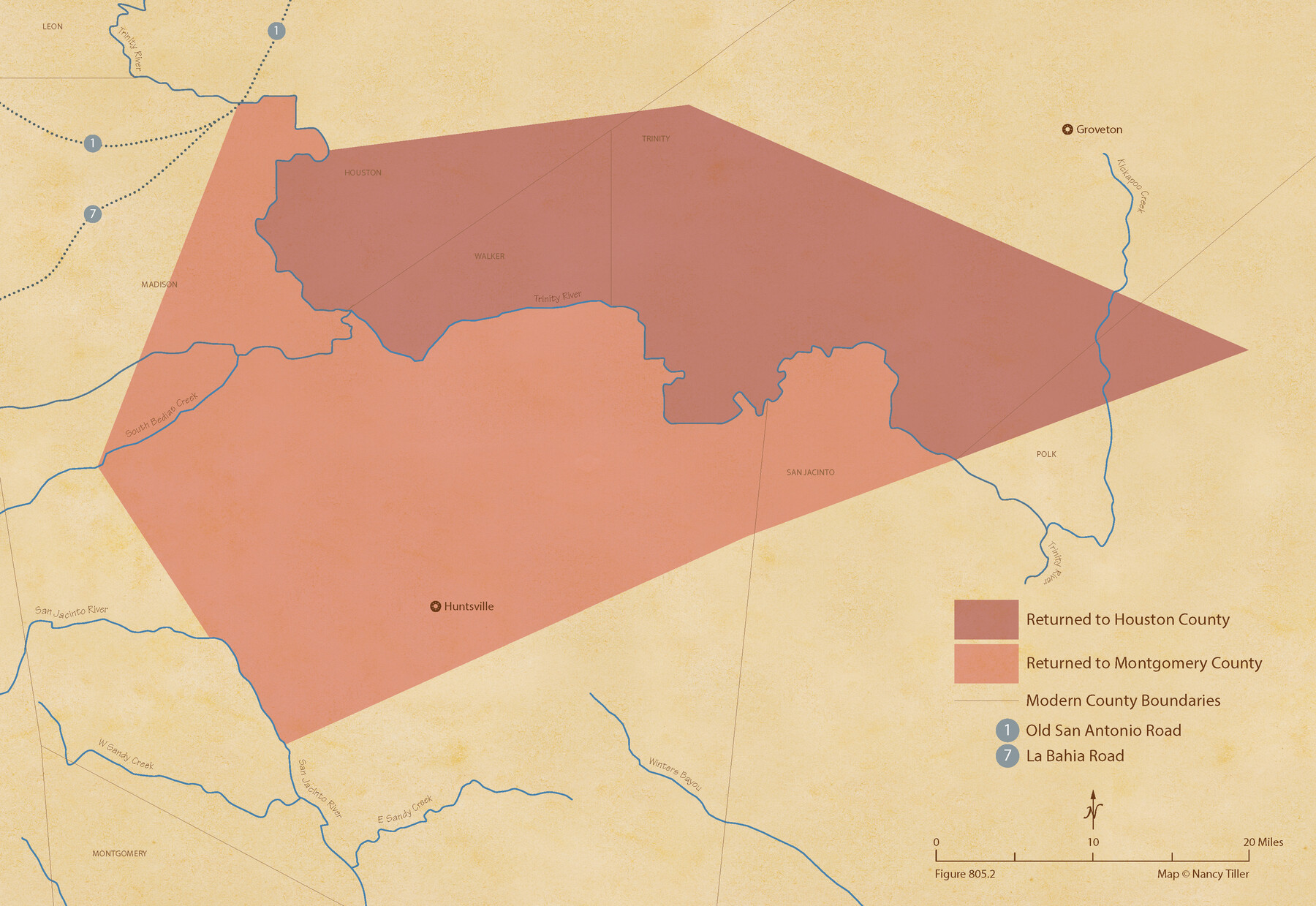
Figure No. 805.2 from 'A Boundary Atlas of Texas, 1821-1845' by Jim Tiller
-
Map/Doc
96330
-
Collection
Nancy and Jim Tiller Digital Collection
-
Object Dates
2020/1/1 (Creation Date)
-
People and Organizations
Jim Tiller (Author)
Nancy Tiller (Cartographer)
Gang Gong (GIS Professional)
-
Subjects
Atlas Republic of Texas Texas Boundaries
-
Height x Width
14.9 x 21.7 inches
37.9 x 55.1 cm
-
Medium
digital image
-
Comments
To purchase a digital PDF copy of "A Boundary Atlas of Texas, 1821-1845" see 96437.
Part of: Nancy and Jim Tiller Digital Collection
The Chief Justice County of Mina. Lands in Conflict with Colorado County

Print $20.00
The Chief Justice County of Mina. Lands in Conflict with Colorado County
2020
Size 15.8 x 21.7 inches
Map/Doc 96062
The Republic County of Victoria. February 2, 1842

Print $20.00
The Republic County of Victoria. February 2, 1842
2020
Size 24.3 x 21.7 inches
Map/Doc 96299
The Empresario Grants. Arthur Goodall Wavell, Proposed Expansion

Print $20.00
The Empresario Grants. Arthur Goodall Wavell, Proposed Expansion
2020
Size 16.0 x 21.7 inches
Map/Doc 96427
The Fisher-Miller Colony. June 7, 1842

Print $20.00
The Fisher-Miller Colony. June 7, 1842
2020
Size 13.8 x 21.7 inches
Map/Doc 96358
The Mexican Municipality of Mina. Created, April 1834

Print $20.00
The Mexican Municipality of Mina. Created, April 1834
2020
Size 10.7 x 21.7 inches
Map/Doc 96028
The Judicial District/County of Menard. Created, January 22, 1841

Print $20.00
The Judicial District/County of Menard. Created, January 22, 1841
2020
Size 22.4 x 21.7 inches
Map/Doc 96335
Republic Counties. January 1, 1840

Print $20.00
Republic Counties. January 1, 1840
2020
Size 24.5 x 21.7 inches
Map/Doc 96313
The Land Offices. No. 7, Milam, December 22, 1836

Print $20.00
The Land Offices. No. 7, Milam, December 22, 1836
2020
Size 23.9 x 21.7 inches
Map/Doc 96420
The Republic County of Lamar. Spring 1842

Print $20.00
The Republic County of Lamar. Spring 1842
2020
Size 16.4 x 21.7 inches
Map/Doc 96204
The Chief Justice County of Gonzales. July 7, 1837

Print $20.00
The Chief Justice County of Gonzales. July 7, 1837
2020
Size 22.3 x 21.7 inches
Map/Doc 96047
The Mexican Department of Brazos. Created, March 18, 1834

Print $20.00
The Mexican Department of Brazos. Created, March 18, 1834
2020
Size 19.7 x 21.7 inches
Map/Doc 95975
The Mexican Municipality of Brazoria. Created, April 28, 1832

Print $20.00
The Mexican Municipality of Brazoria. Created, April 28, 1832
2020
Size 16.5 x 21.7 inches
Map/Doc 96015
You may also like
Harris County Working Sketch 7

Print $20.00
- Digital $50.00
Harris County Working Sketch 7
1900
Size 34.2 x 28.6 inches
Map/Doc 65899
Val Verde County Sketch File 18

Print $8.00
- Digital $50.00
Val Verde County Sketch File 18
1883
Size 13.1 x 8.4 inches
Map/Doc 39225
[Surveys along Green's Creek and the North Bosque River]
![69756, [Surveys along Green's Creek and the North Bosque River], General Map Collection](https://historictexasmaps.com/wmedia_w700/maps/69756.tif.jpg)
Print $2.00
- Digital $50.00
[Surveys along Green's Creek and the North Bosque River]
1846
Size 11.9 x 8.1 inches
Map/Doc 69756
Marion County Rolled Sketch 2

Print $40.00
- Digital $50.00
Marion County Rolled Sketch 2
1954
Size 89.3 x 45.7 inches
Map/Doc 63912
Matagorda County Sketch File 23

Print $4.00
- Digital $50.00
Matagorda County Sketch File 23
1898
Size 14.2 x 8.6 inches
Map/Doc 30785
Cooke County Sketch File 29

Print $16.00
- Digital $50.00
Cooke County Sketch File 29
1873
Size 8.2 x 11.0 inches
Map/Doc 19283
Kleberg County Rolled Sketch 12

Print $20.00
- Digital $50.00
Kleberg County Rolled Sketch 12
1994
Size 25.8 x 36.6 inches
Map/Doc 6553
Brewster County Rolled Sketch K

Print $20.00
- Digital $50.00
Brewster County Rolled Sketch K
1884
Size 19.6 x 13.9 inches
Map/Doc 5321
Plat showing survey of tracts in the C. A. West survey A-337 and the Wm. Standiferd survey A-301 in Bastrop County as surveyed for the Veteran's Land Board

Print $20.00
- Digital $50.00
Plat showing survey of tracts in the C. A. West survey A-337 and the Wm. Standiferd survey A-301 in Bastrop County as surveyed for the Veteran's Land Board
1992
Size 34.9 x 46.8 inches
Map/Doc 61151

Bexar County Working Sketch 6

Print $40.00
- Digital $50.00
Bexar County Working Sketch 6
1945
Size 56.4 x 41.2 inches
Map/Doc 67322
Rio Grande Rectification Project, El Paso and Juarez Valley

Print $20.00
- Digital $50.00
Rio Grande Rectification Project, El Paso and Juarez Valley
1935
Size 10.7 x 29.6 inches
Map/Doc 60866