Kleberg County Rolled Sketch 12
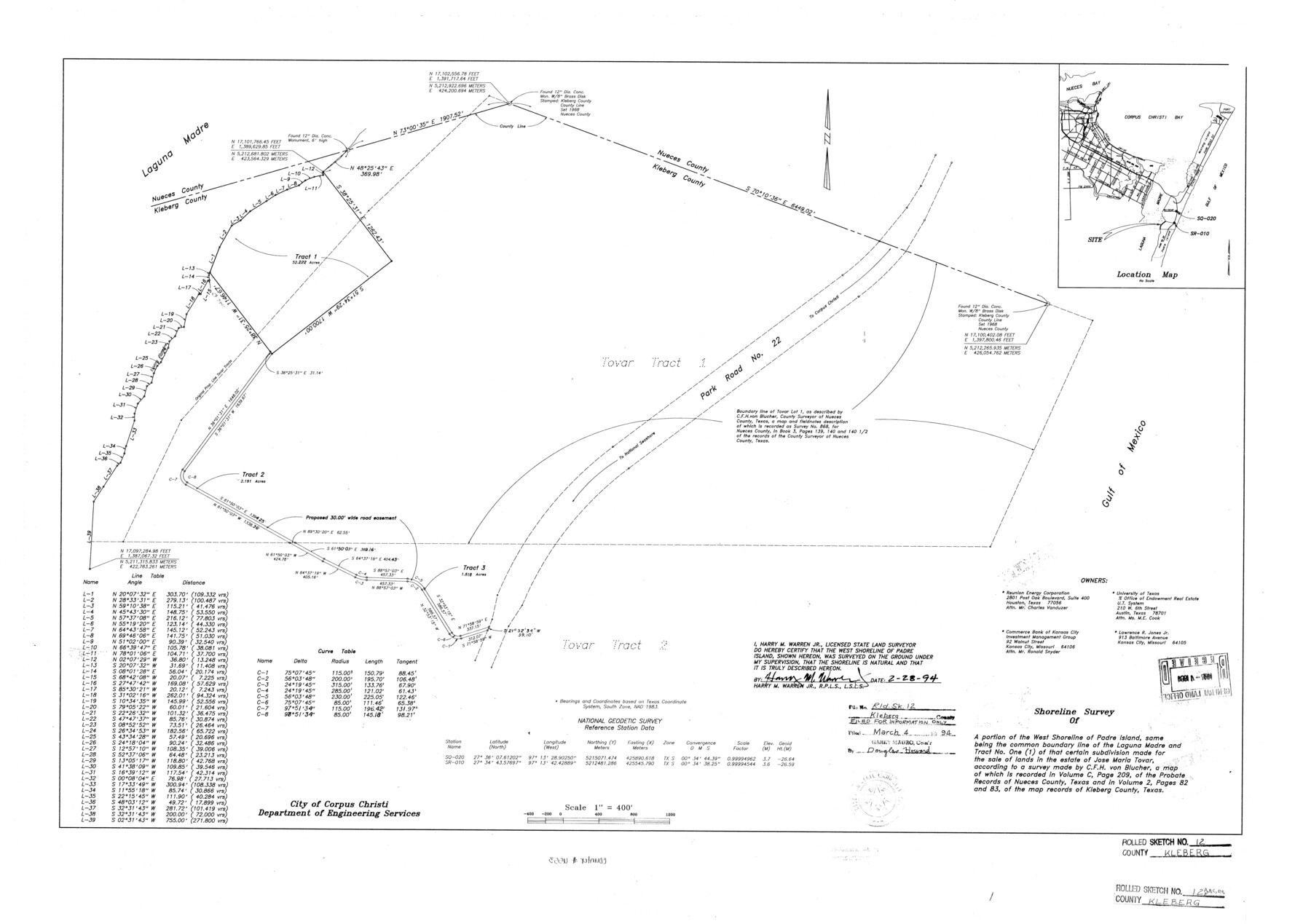
Shoreline survey of a portion of the west shoreline of Padre Island, same being the common boundary line of the Laguna Madre and tract no. one (1) of that certain subdivision made for the sale of lands in the estate of Jose Maria Tovar
-
Map/Doc
6553
-
Collection
General Map Collection
-
Object Dates
2/28/1994 (Creation Date)
3/4/1994 (File Date)
-
People and Organizations
Harry M. Warren, Jr. (Surveyor/Engineer)
-
Counties
Kleberg
-
Subjects
Surveying Rolled Sketch
-
Height x Width
25.8 x 36.6 inches
65.5 x 93.0 cm
-
Comments
Filed for information only.
See Kleberg County Rolled Sketch 12A-F (61769) for accompanying aerial photographs and correspondence.
Related maps

Part of: General Map Collection
Hudspeth County Sketch File 4b

Print $20.00
- Digital $50.00
Hudspeth County Sketch File 4b
1860
Size 13.0 x 39.2 inches
Map/Doc 10492
Angelina County Working Sketch 45

Print $20.00
- Digital $50.00
Angelina County Working Sketch 45
1976
Size 25.8 x 29.7 inches
Map/Doc 67128
Matagorda County Working Sketch 11

Print $20.00
- Digital $50.00
Matagorda County Working Sketch 11
1957
Size 34.6 x 43.6 inches
Map/Doc 70869
Presidio County Working Sketch 60

Print $20.00
- Digital $50.00
Presidio County Working Sketch 60
1957
Size 21.9 x 18.4 inches
Map/Doc 71737
Hemphill County Boundary File 2

Print $54.00
- Digital $50.00
Hemphill County Boundary File 2
Size 8.6 x 32.1 inches
Map/Doc 54621
Controlled Mosaic by Jack Amman Photogrammetric Engineers, Inc - Sheet 38

Print $20.00
- Digital $50.00
Controlled Mosaic by Jack Amman Photogrammetric Engineers, Inc - Sheet 38
1954
Size 20.0 x 24.0 inches
Map/Doc 83493
Flight Mission No. DQO-12K, Frame 40, Galveston County

Print $20.00
- Digital $50.00
Flight Mission No. DQO-12K, Frame 40, Galveston County
1952
Size 18.6 x 22.3 inches
Map/Doc 85230
Flight Mission No. DQN-7K, Frame 36, Calhoun County

Print $20.00
- Digital $50.00
Flight Mission No. DQN-7K, Frame 36, Calhoun County
1953
Size 18.5 x 22.2 inches
Map/Doc 84474
Val Verde County Rolled Sketch 38

Print $20.00
- Digital $50.00
Val Verde County Rolled Sketch 38
Size 30.4 x 19.5 inches
Map/Doc 61781
Coke County Rolled Sketch 21

Print $20.00
- Digital $50.00
Coke County Rolled Sketch 21
1954
Size 14.0 x 24.4 inches
Map/Doc 5522
Dallas County Boundary File 6e

Print $70.00
- Digital $50.00
Dallas County Boundary File 6e
Size 16.6 x 22.5 inches
Map/Doc 52254
Brewster County Rolled Sketch 101

Print $40.00
- Digital $50.00
Brewster County Rolled Sketch 101
1927
Size 74.2 x 42.3 inches
Map/Doc 9192
You may also like
Harris County Rolled Sketch WHW

Print $20.00
- Digital $50.00
Harris County Rolled Sketch WHW
1930
Size 20.7 x 41.6 inches
Map/Doc 6466
Working Sketch in Bastrop County

Print $20.00
- Digital $50.00
Working Sketch in Bastrop County
1921
Size 14.3 x 15.6 inches
Map/Doc 90233
Newton County Working Sketch 10

Print $20.00
- Digital $50.00
Newton County Working Sketch 10
1941
Size 17.1 x 21.6 inches
Map/Doc 71256
Map of Baffin & Alazan Bays, Cayo Infiernillo in Kenedy & Kleberg Counties Showing Subdivision for Mineral Development

Print $20.00
- Digital $50.00
Map of Baffin & Alazan Bays, Cayo Infiernillo in Kenedy & Kleberg Counties Showing Subdivision for Mineral Development
1937
Size 42.4 x 40.4 inches
Map/Doc 3016
La Salle County Working Sketch 50

Print $40.00
- Digital $50.00
La Salle County Working Sketch 50
1985
Size 50.6 x 26.2 inches
Map/Doc 70351
Bandera County Sketch File 21

Print $4.00
- Digital $50.00
Bandera County Sketch File 21
Size 12.7 x 8.1 inches
Map/Doc 14010
El Paso County Rolled Sketch 40

Print $20.00
- Digital $50.00
El Paso County Rolled Sketch 40
1930
Size 11.6 x 16.8 inches
Map/Doc 5826
Presidio County Rolled Sketch 75

Print $20.00
- Digital $50.00
Presidio County Rolled Sketch 75
1938
Size 24.8 x 20.0 inches
Map/Doc 7363
Texas 1971 Official State Highway Map

Digital $50.00
Texas 1971 Official State Highway Map
Size 28.3 x 36.5 inches
Map/Doc 94316
Red River County Working Sketch 75

Print $20.00
- Digital $50.00
Red River County Working Sketch 75
1980
Size 30.4 x 24.6 inches
Map/Doc 72058
Grayson County Working Sketch 2

Print $20.00
- Digital $50.00
Grayson County Working Sketch 2
1939
Size 27.8 x 40.9 inches
Map/Doc 63241
Brazoria County Sketch File 11

Print $4.00
- Digital $50.00
Brazoria County Sketch File 11
Size 10.5 x 8.5 inches
Map/Doc 14965