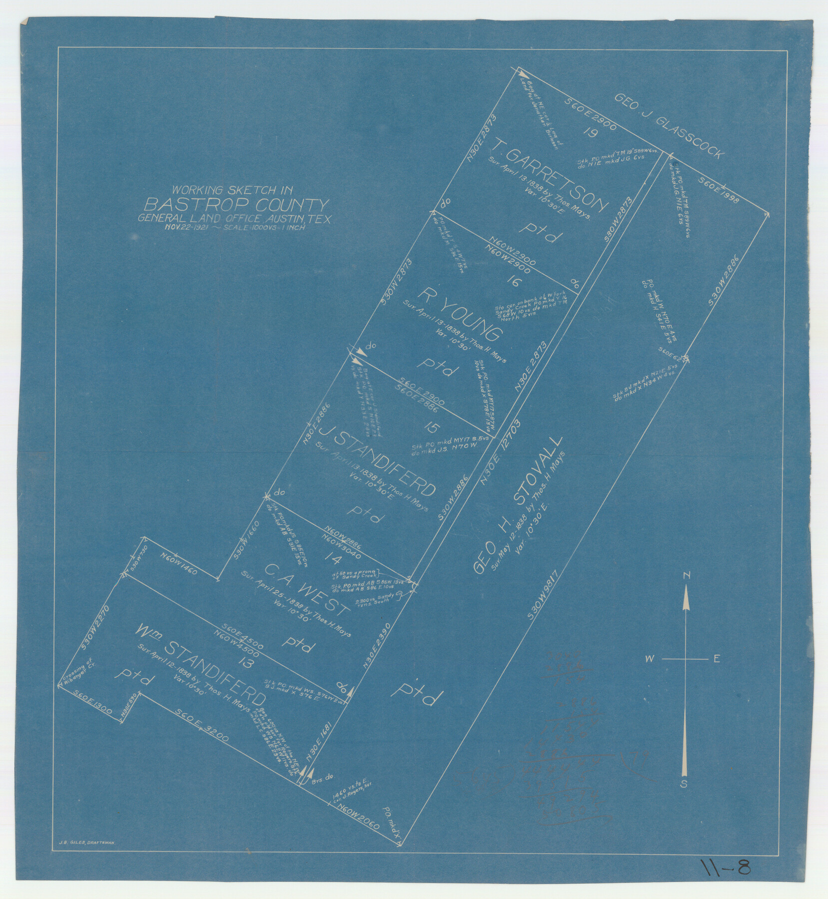
Working Sketch in Bastrop County
11-8
-
Map/Doc
90233
-
Collection
Twichell Survey Records
-
Object Dates
11/22/1921 (Creation Date)
-
People and Organizations
J.B. Giles (Draftsman)
-
Counties
Bastrop
-
Height x Width
14.3 x 15.6 inches
36.3 x 39.6 cm
Part of: Twichell Survey Records
[Sutton, Hale & Ector Co. School Land]
![90102, [Sutton, Hale & Ector Co. School Land], Twichell Survey Records](https://historictexasmaps.com/wmedia_w700/maps/90102-1.tif.jpg)
Print $3.00
- Digital $50.00
[Sutton, Hale & Ector Co. School Land]
Size 9.7 x 16.8 inches
Map/Doc 90102
Revised Sectional Map Number 2, Lands in Texas and Pacific Railway Reservation From Westbrook Station in Mitchell County to Metz Station in Ector County

Print $20.00
- Digital $50.00
Revised Sectional Map Number 2, Lands in Texas and Pacific Railway Reservation From Westbrook Station in Mitchell County to Metz Station in Ector County
Size 25.1 x 19.6 inches
Map/Doc 91366
University of Texas System University Lands

Print $20.00
- Digital $50.00
University of Texas System University Lands
Size 23.2 x 17.6 inches
Map/Doc 93235
Roberts Addition to the City of Morton

Print $3.00
- Digital $50.00
Roberts Addition to the City of Morton
1958
Size 11.8 x 11.4 inches
Map/Doc 92540
[Sketch of part of G. & M. Block 5, G. & M. Block 4, Block M19 and Block 21W]
![93079, [Sketch of part of G. & M. Block 5, G. & M. Block 4, Block M19 and Block 21W], Twichell Survey Records](https://historictexasmaps.com/wmedia_w700/maps/93079-1.tif.jpg)
Print $20.00
- Digital $50.00
[Sketch of part of G. & M. Block 5, G. & M. Block 4, Block M19 and Block 21W]
Size 22.8 x 15.6 inches
Map/Doc 93079
Map of Adrian, the New Town in the Panhandle, Oldham County, Texas (verso - Adrian promotional text)

Print $20.00
- Digital $50.00
Map of Adrian, the New Town in the Panhandle, Oldham County, Texas (verso - Adrian promotional text)
Size 26.0 x 21.5 inches
Map/Doc 92136
Portion of Lands in Parmer County, Texas Owned and For Sale by Capitol Freehold Land and Investment Co., Ltd.

Print $3.00
- Digital $50.00
Portion of Lands in Parmer County, Texas Owned and For Sale by Capitol Freehold Land and Investment Co., Ltd.
Size 16.7 x 11.3 inches
Map/Doc 91550
Working Sketch Compiled from Original Field Showing Surveys in Irion County Located by J. A. McDonald in 1856 and 1858

Print $20.00
- Digital $50.00
Working Sketch Compiled from Original Field Showing Surveys in Irion County Located by J. A. McDonald in 1856 and 1858
Size 13.1 x 13.8 inches
Map/Doc 92191
[I. G. Yates survey and adjacent area south of Runnels County School Land]
![91679, [I. G. Yates survey and adjacent area south of Runnels County School Land], Twichell Survey Records](https://historictexasmaps.com/wmedia_w700/maps/91679-1.tif.jpg)
Print $20.00
- Digital $50.00
[I. G. Yates survey and adjacent area south of Runnels County School Land]
Size 15.1 x 14.5 inches
Map/Doc 91679
Pecos County Sketch

Print $20.00
- Digital $50.00
Pecos County Sketch
1928
Size 38.6 x 21.6 inches
Map/Doc 91616
[B. S. & F. Block M7]
![90393, [B. S. & F. Block M7], Twichell Survey Records](https://historictexasmaps.com/wmedia_w700/maps/90393-1.tif.jpg)
Print $20.00
- Digital $50.00
[B. S. & F. Block M7]
1905
Size 21.7 x 17.9 inches
Map/Doc 90393
Plat of Fee Land Adjoining the Town of Lovington, New Mexico

Print $20.00
- Digital $50.00
Plat of Fee Land Adjoining the Town of Lovington, New Mexico
Size 24.2 x 18.4 inches
Map/Doc 92422
You may also like
Current Miscellaneous File 36

Print $12.00
- Digital $50.00
Current Miscellaneous File 36
Size 10.3 x 12.4 inches
Map/Doc 73952
Flight Mission No. BRE-2P, Frame 16, Nueces County

Print $20.00
- Digital $50.00
Flight Mission No. BRE-2P, Frame 16, Nueces County
1956
Size 18.3 x 22.2 inches
Map/Doc 86725
Terrell County Rolled Sketch 48

Print $20.00
- Digital $50.00
Terrell County Rolled Sketch 48
1959
Size 20.5 x 22.3 inches
Map/Doc 7950
Floyd County Sketch File 34

Print $4.00
- Digital $50.00
Floyd County Sketch File 34
1892
Size 11.3 x 8.9 inches
Map/Doc 22798

Miller-Stevens Subdivision Section 16, Block B

Print $20.00
- Digital $50.00
Miller-Stevens Subdivision Section 16, Block B
1944
Size 24.2 x 39.8 inches
Map/Doc 92401
Brewster County Working Sketch 55

Print $40.00
- Digital $50.00
Brewster County Working Sketch 55
1953
Size 51.1 x 27.5 inches
Map/Doc 67656
Map of north end of Brazos Island

Print $20.00
- Digital $50.00
Map of north end of Brazos Island
1845
Size 24.2 x 18.3 inches
Map/Doc 72920
Garza County Rolled Sketch 7

Print $11.00
- Digital $50.00
Garza County Rolled Sketch 7
1905
Size 10.0 x 15.4 inches
Map/Doc 45229
Palo Pinto County Working Sketch 26

Print $20.00
- Digital $50.00
Palo Pinto County Working Sketch 26
1993
Map/Doc 71409
Flight Mission No. DAG-26K, Frame 56, Matagorda County

Print $20.00
- Digital $50.00
Flight Mission No. DAG-26K, Frame 56, Matagorda County
1953
Size 18.6 x 22.7 inches
Map/Doc 86576
McMullen County Sketch File 4

Print $4.00
- Digital $50.00
McMullen County Sketch File 4
Size 7.9 x 10.1 inches
Map/Doc 31341