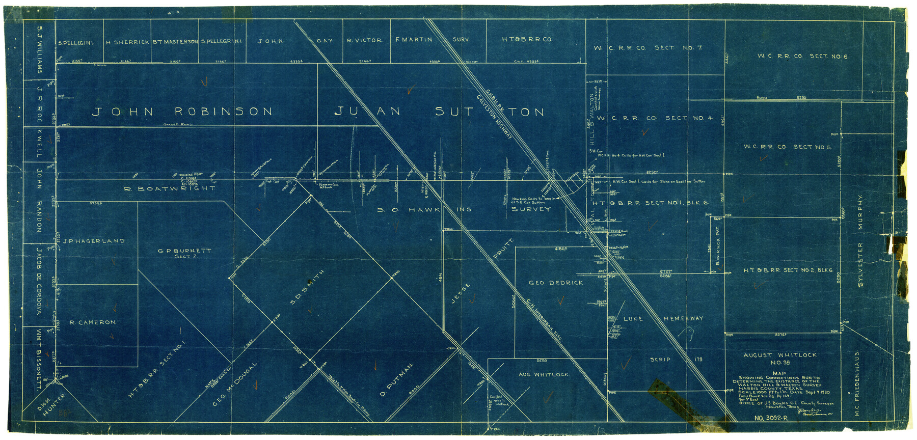
Harris County Rolled Sketch WHW
Map showing connections run to determine the existance of the Walton Hill & Walton survey
-
Map/Doc
6466
-
Collection
General Map Collection
-
Object Dates
9/9/1930 (Creation Date)
-
People and Organizations
J.S. Boyles (Surveyor/Engineer)
-
Counties
Harris
-
Subjects
Surveying Rolled Sketch
-
Height x Width
20.7 x 41.6 inches
52.6 x 105.7 cm
-
Medium
blueprint/diazo
-
Scale
1" = 1000 feet
-
Comments
See Harris County Rolled Sketch WHW2 (6148) for related sketch.
Related maps
Harris County Rolled Sketch WHW2

Print $20.00
- Digital $50.00
Harris County Rolled Sketch WHW2
Size 15.5 x 14.4 inches
Map/Doc 6148
Part of: General Map Collection
Moore County Working Sketch 12

Print $20.00
- Digital $50.00
Moore County Working Sketch 12
1952
Size 33.1 x 28.4 inches
Map/Doc 71194
South Part of Brewster Co.

Print $40.00
- Digital $50.00
South Part of Brewster Co.
1955
Size 48.9 x 41.4 inches
Map/Doc 95438
Newton County Rolled Sketch 6

Print $20.00
- Digital $50.00
Newton County Rolled Sketch 6
Size 24.9 x 45.7 inches
Map/Doc 6842
Real County Working Sketch 58

Print $20.00
- Digital $50.00
Real County Working Sketch 58
1962
Size 24.7 x 28.5 inches
Map/Doc 71950
Tom Green County Rolled Sketch 26

Print $40.00
- Digital $50.00
Tom Green County Rolled Sketch 26
Size 40.0 x 48.3 inches
Map/Doc 10007
Martin County Sketch File 12

Print $20.00
- Digital $50.00
Martin County Sketch File 12
1937
Size 22.9 x 19.5 inches
Map/Doc 12030
Brewster County Rolled Sketch 71

Print $20.00
- Digital $50.00
Brewster County Rolled Sketch 71
1940
Size 29.9 x 42.9 inches
Map/Doc 8491
[Surveys in the Jefferson District on the Sabine River]
![325, [Surveys in the Jefferson District on the Sabine River], General Map Collection](https://historictexasmaps.com/wmedia_w700/maps/325.tif.jpg)
Print $2.00
- Digital $50.00
[Surveys in the Jefferson District on the Sabine River]
1841
Size 8.7 x 7.8 inches
Map/Doc 325
Wharton County Working Sketch 8

Print $20.00
- Digital $50.00
Wharton County Working Sketch 8
1983
Size 37.2 x 32.3 inches
Map/Doc 72472
Uvalde County Sketch File 32

Print $12.00
- Digital $50.00
Uvalde County Sketch File 32
2008
Size 8.5 x 11.0 inches
Map/Doc 89025
Township 8 North Range 14 West, North Western District, Louisiana

Print $20.00
- Digital $50.00
Township 8 North Range 14 West, North Western District, Louisiana
1854
Size 19.7 x 24.7 inches
Map/Doc 65874
Dallas County Sketch File 17

Print $20.00
- Digital $50.00
Dallas County Sketch File 17
Size 17.1 x 18.0 inches
Map/Doc 11285
You may also like
Webb County Rolled Sketch 53

Print $40.00
- Digital $50.00
Webb County Rolled Sketch 53
1944
Size 83.5 x 28.6 inches
Map/Doc 49483
Chicago, Rock Island, Texas & Mexico

Print $20.00
- Digital $50.00
Chicago, Rock Island, Texas & Mexico
1920
Size 23.9 x 13.8 inches
Map/Doc 64423
C. B. Livestock Co.'s West-Ranch, Bailey County, Texas

Print $2.00
- Digital $50.00
C. B. Livestock Co.'s West-Ranch, Bailey County, Texas
Size 11.2 x 8.9 inches
Map/Doc 90381
[J. Blackwell survey 150, E. Parker, Asa Dorsett survey 827 and surrounding surveys]
![90422, [J. Blackwell survey 150, E. Parker, Asa Dorsett survey 827 and surrounding surveys], Twichell Survey Records](https://historictexasmaps.com/wmedia_w700/maps/90422-1.tif.jpg)
Print $20.00
- Digital $50.00
[J. Blackwell survey 150, E. Parker, Asa Dorsett survey 827 and surrounding surveys]
Size 35.0 x 30.3 inches
Map/Doc 90422
Atlantic Coast to the Rocky Mountains

Atlantic Coast to the Rocky Mountains
1956
Size 42.3 x 29.5 inches
Map/Doc 94410
Kleberg County Rolled Sketch 10-12

Print $20.00
- Digital $50.00
Kleberg County Rolled Sketch 10-12
1951
Size 38.8 x 34.9 inches
Map/Doc 9371
[Panhandle Counties]
![89923, [Panhandle Counties], Twichell Survey Records](https://historictexasmaps.com/wmedia_w700/maps/89923-1.tif.jpg)
Print $20.00
- Digital $50.00
[Panhandle Counties]
1930
Size 42.3 x 42.8 inches
Map/Doc 89923
Carson County Working Sketch 2

Print $3.00
- Digital $50.00
Carson County Working Sketch 2
1907
Size 16.7 x 10.0 inches
Map/Doc 67873
General Highway Map, Randall County, Texas

Print $20.00
General Highway Map, Randall County, Texas
1940
Size 18.3 x 25.0 inches
Map/Doc 79224
Starr County Sketch File 31A

Print $20.00
- Digital $50.00
Starr County Sketch File 31A
1936
Size 24.5 x 13.3 inches
Map/Doc 12335
Roberts County Working Sketch 18

Print $20.00
- Digital $50.00
Roberts County Working Sketch 18
1975
Size 35.6 x 39.7 inches
Map/Doc 63544
Sabine Pass and Lake

Print $40.00
- Digital $50.00
Sabine Pass and Lake
1992
Size 49.2 x 28.6 inches
Map/Doc 69828