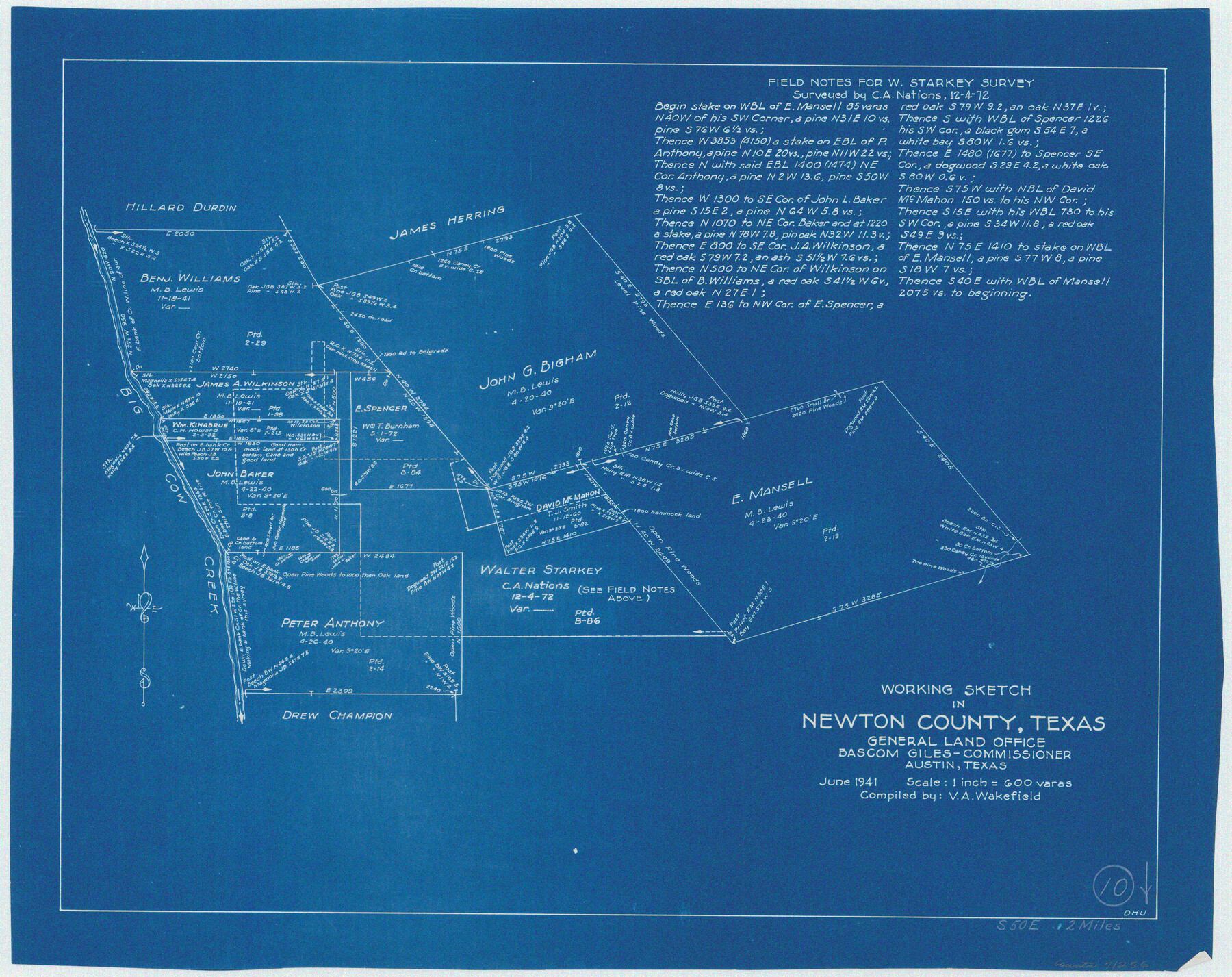
Newton County Working Sketch 10
-
Map/Doc
71256
-
Collection
General Map Collection
-
Object Dates
6/1941 (Creation Date)
-
People and Organizations
Dorothy H. Underwood (Draftsman)
V.A. Wakefield (Compiler)
-
Counties
Newton
-
Subjects
Surveying Working Sketch
-
Height x Width
17.1 x 21.6 inches
43.4 x 54.9 cm
-
Scale
1" = 600 varas
Part of: General Map Collection
Coryell County Sketch File 8

Print $6.00
- Digital $50.00
Coryell County Sketch File 8
1853
Size 16.0 x 10.2 inches
Map/Doc 19357
Brewster County Rolled Sketch A

Print $40.00
- Digital $50.00
Brewster County Rolled Sketch A
Size 26.7 x 94.8 inches
Map/Doc 8925
El Paso County Working Sketch 54

Print $20.00
- Digital $50.00
El Paso County Working Sketch 54
1992
Size 31.5 x 29.0 inches
Map/Doc 69076
Topographical Map of the Rio Grande, Sheet No. 16

Print $20.00
- Digital $50.00
Topographical Map of the Rio Grande, Sheet No. 16
1912
Map/Doc 89540
Jefferson Co.

Print $20.00
- Digital $50.00
Jefferson Co.
1978
Size 47.0 x 41.1 inches
Map/Doc 77329
Dallas County Sketch File 1

Print $4.00
- Digital $50.00
Dallas County Sketch File 1
1853
Size 7.2 x 7.0 inches
Map/Doc 20394
Starr County Sketch File 46 1/2

Print $20.00
- Digital $50.00
Starr County Sketch File 46 1/2
1978
Size 17.9 x 17.2 inches
Map/Doc 12344
Coast of Texas and its defences

Print $20.00
- Digital $50.00
Coast of Texas and its defences
Size 27.8 x 18.2 inches
Map/Doc 72684
Hudspeth County Working Sketch 45

Print $20.00
- Digital $50.00
Hudspeth County Working Sketch 45
1983
Size 34.7 x 43.2 inches
Map/Doc 66330

Parker County Boundary File 3a

Print $34.00
- Digital $50.00
Parker County Boundary File 3a
Size 11.2 x 8.8 inches
Map/Doc 57840
Sabine County Sketch File 9

Print $6.00
Sabine County Sketch File 9
1912
Size 12.7 x 8.0 inches
Map/Doc 35624
You may also like
Maverick County Sketch File 3

Print $40.00
- Digital $50.00
Maverick County Sketch File 3
Size 18.3 x 11.6 inches
Map/Doc 31033
[Blueprint of unknown Block/Surveys]
![92139, [Blueprint of unknown Block/Surveys], Twichell Survey Records](https://historictexasmaps.com/wmedia_w700/maps/92139-1.tif.jpg)
Print $20.00
- Digital $50.00
[Blueprint of unknown Block/Surveys]
Size 24.7 x 26.8 inches
Map/Doc 92139
Cottle County Sketch File 4

Print $16.00
- Digital $50.00
Cottle County Sketch File 4
Size 8.2 x 4.2 inches
Map/Doc 19466
Cass County Working Sketch 47b

Print $20.00
- Digital $50.00
Cass County Working Sketch 47b
1992
Size 32.3 x 36.4 inches
Map/Doc 76063
Outer Continental Shelf Leasing Maps (Louisiana Offshore Operations)

Print $20.00
- Digital $50.00
Outer Continental Shelf Leasing Maps (Louisiana Offshore Operations)
1959
Size 18.1 x 14.3 inches
Map/Doc 76110
Map of Dallas County

Print $20.00
- Digital $50.00
Map of Dallas County
1861
Size 23.5 x 20.0 inches
Map/Doc 3467
Edwards County Working Sketch 50

Print $20.00
- Digital $50.00
Edwards County Working Sketch 50
1950
Size 35.8 x 28.9 inches
Map/Doc 68926
Crockett County Sketch File 75

Print $20.00
- Digital $50.00
Crockett County Sketch File 75
Size 26.3 x 28.8 inches
Map/Doc 11234
Map of Eastern Portion G.C. & S.F.R.R.Co., Block 194

Print $20.00
- Digital $50.00
Map of Eastern Portion G.C. & S.F.R.R.Co., Block 194
Size 35.6 x 26.8 inches
Map/Doc 92421
Gillespie County Rolled Sketch 6

Print $20.00
- Digital $50.00
Gillespie County Rolled Sketch 6
2005
Size 18.2 x 24.6 inches
Map/Doc 83253
Flight Mission No. DAG-23K, Frame 180, Matagorda County

Print $20.00
- Digital $50.00
Flight Mission No. DAG-23K, Frame 180, Matagorda County
1953
Size 18.4 x 16.0 inches
Map/Doc 86515
Baylor County Sketch File A7

Print $6.00
- Digital $50.00
Baylor County Sketch File A7
1899
Size 9.1 x 14.6 inches
Map/Doc 14091