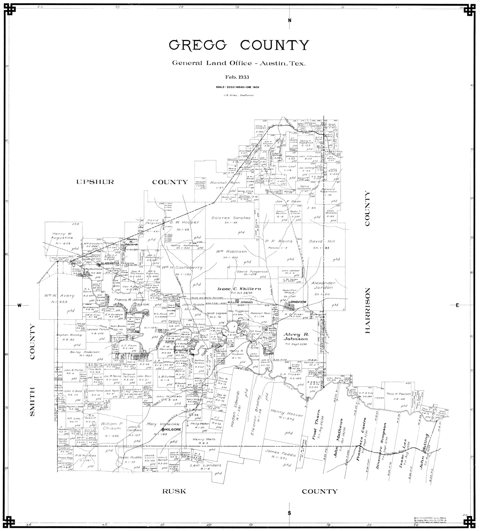
Gregg County
-
Map/Doc
77295
-
Collection
General Map Collection
-
Object Dates
1933 (Creation Date)
-
People and Organizations
J. Bascom Giles (Draftsman)
-
Counties
Gregg
-
Subjects
County
-
Height x Width
40.3 x 36.4 inches
102.4 x 92.5 cm
Part of: General Map Collection
Uvalde County Sketch File 32

Print $12.00
- Digital $50.00
Uvalde County Sketch File 32
2008
Size 8.5 x 11.0 inches
Map/Doc 89025
Travis County Rolled Sketch 17

Print $20.00
- Digital $50.00
Travis County Rolled Sketch 17
1940
Size 18.8 x 25.4 inches
Map/Doc 8019
Dallam County Boundary File 2

Print $18.00
- Digital $50.00
Dallam County Boundary File 2
Size 8.7 x 4.3 inches
Map/Doc 52053
Flight Mission No. DCL-3C, Frame 156, Kenedy County

Print $20.00
- Digital $50.00
Flight Mission No. DCL-3C, Frame 156, Kenedy County
1943
Size 18.5 x 22.3 inches
Map/Doc 85804
Pecos County Working Sketch 62

Print $40.00
- Digital $50.00
Pecos County Working Sketch 62
1952
Size 32.3 x 59.1 inches
Map/Doc 71534
Val Verde County Rolled Sketch 79

Print $20.00
- Digital $50.00
Val Verde County Rolled Sketch 79
1983
Size 25.6 x 21.7 inches
Map/Doc 8141
Brewster County Rolled Sketch 148B

Print $20.00
- Digital $50.00
Brewster County Rolled Sketch 148B
1994
Size 28.0 x 36.3 inches
Map/Doc 5315
Reeves County Rolled Sketch 29

Print $20.00
- Digital $50.00
Reeves County Rolled Sketch 29
1986
Size 21.6 x 27.5 inches
Map/Doc 7498
El Paso County State Real Property Sketch 2

Print $20.00
- Digital $50.00
El Paso County State Real Property Sketch 2
2007
Size 24.4 x 36.2 inches
Map/Doc 88671
Flight Mission No. CRK-3P, Frame 65, Refugio County

Print $20.00
- Digital $50.00
Flight Mission No. CRK-3P, Frame 65, Refugio County
1956
Size 18.5 x 22.4 inches
Map/Doc 86907
[Sketch for Mineral Application 26649-26650 - Sabine River, Harry A. Wolan]
![65566, [Sketch for Mineral Application 26649-26650 - Sabine River, Harry A. Wolan], General Map Collection](https://historictexasmaps.com/wmedia_w700/maps/65566.tif.jpg)
Print $40.00
- Digital $50.00
[Sketch for Mineral Application 26649-26650 - Sabine River, Harry A. Wolan]
Size 72.0 x 36.9 inches
Map/Doc 65566
Orange County Rolled Sketch 18

Print $20.00
- Digital $50.00
Orange County Rolled Sketch 18
Size 11.6 x 12.6 inches
Map/Doc 7182
You may also like
[Sketch for Mineral Application 24072, San Jacinto River]
![65592, [Sketch for Mineral Application 24072, San Jacinto River], General Map Collection](https://historictexasmaps.com/wmedia_w700/maps/65592.tif.jpg)
Print $20.00
- Digital $50.00
[Sketch for Mineral Application 24072, San Jacinto River]
1929
Size 39.7 x 21.0 inches
Map/Doc 65592
Baylor County Sketch File 20

Print $8.00
- Digital $50.00
Baylor County Sketch File 20
1887
Size 12.9 x 8.2 inches
Map/Doc 14195

Flight Mission No. BRA-16M, Frame 83, Jefferson County

Print $20.00
- Digital $50.00
Flight Mission No. BRA-16M, Frame 83, Jefferson County
1953
Size 18.5 x 22.3 inches
Map/Doc 85695
Lampasas County Sketch File 6

Print $4.00
- Digital $50.00
Lampasas County Sketch File 6
1871
Size 8.0 x 6.8 inches
Map/Doc 29400
Atascosa County Rolled Sketch 5B1

Print $20.00
- Digital $50.00
Atascosa County Rolled Sketch 5B1
Size 14.6 x 11.7 inches
Map/Doc 5090
The Republic County of Nacogdoches. Proposed, Late Fall 1837

Print $20.00
The Republic County of Nacogdoches. Proposed, Late Fall 1837
2020
Size 17.5 x 21.7 inches
Map/Doc 96242
Carte du Mexique et de la Floride des Terres Angloises et des Isles Antilles du Cours et des Environs de la Riviere Mississipi

Print $20.00
- Digital $50.00
Carte du Mexique et de la Floride des Terres Angloises et des Isles Antilles du Cours et des Environs de la Riviere Mississipi
1703
Size 21.8 x 30.0 inches
Map/Doc 94852
University Land, El Paso County

Print $20.00
- Digital $50.00
University Land, El Paso County
1906
Size 25.1 x 31.4 inches
Map/Doc 2428
Kerr County Working Sketch 8

Print $20.00
- Digital $50.00
Kerr County Working Sketch 8
1948
Size 18.1 x 23.6 inches
Map/Doc 70039
General Highway Map, Starr County, Texas

Print $20.00
General Highway Map, Starr County, Texas
1961
Size 25.1 x 18.3 inches
Map/Doc 79659
Reagan County Working Sketch 12

Print $20.00
- Digital $50.00
Reagan County Working Sketch 12
1948
Size 24.1 x 44.9 inches
Map/Doc 71852