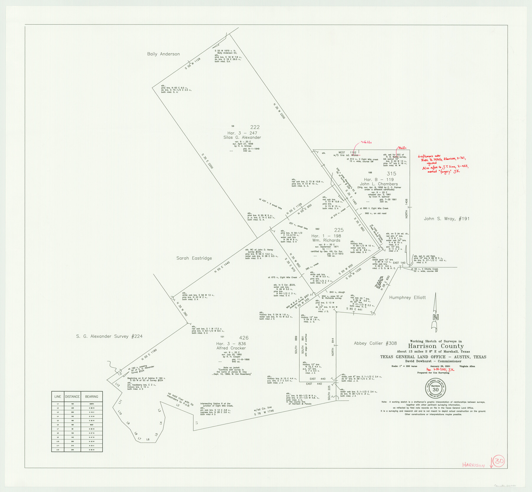
Harrison County Working Sketch 30
-
Map/Doc
66050
-
Collection
General Map Collection
-
Object Dates
1/26/2001 (Creation Date)
1/30/2001 (Revision Date)
-
People and Organizations
Virginia Allen (Draftsman)
Joan Kilpatrick (Draftsman)
-
Counties
Harrison
-
Subjects
Surveying Working Sketch
-
Height x Width
29.5 x 31.9 inches
74.9 x 81.0 cm
-
Scale
1" = 200 varas
Part of: General Map Collection
Marion County Working Sketch 33

Print $20.00
- Digital $50.00
Marion County Working Sketch 33
1983
Size 16.0 x 20.7 inches
Map/Doc 70809
Crockett County Working Sketch 85

Print $40.00
- Digital $50.00
Crockett County Working Sketch 85
1976
Size 23.4 x 54.8 inches
Map/Doc 68418
Colorado County Working Sketch Graphic Index

Print $40.00
- Digital $50.00
Colorado County Working Sketch Graphic Index
1946
Size 52.7 x 42.4 inches
Map/Doc 76500
Right of Way and Track Map, International & Gt. Northern Ry. operated by the International & Gt. Northern Ry. Co. Gulf Division, Mineola Branch

Print $40.00
- Digital $50.00
Right of Way and Track Map, International & Gt. Northern Ry. operated by the International & Gt. Northern Ry. Co. Gulf Division, Mineola Branch
1917
Size 27.8 x 118.1 inches
Map/Doc 64704
Nautical Chart 152-SC - Galveston Bay, Texas

Print $20.00
- Digital $50.00
Nautical Chart 152-SC - Galveston Bay, Texas
1972
Size 15.1 x 32.6 inches
Map/Doc 69892
Burnet County Boundary File 4

Print $30.00
- Digital $50.00
Burnet County Boundary File 4
Size 8.8 x 8.1 inches
Map/Doc 50872
King County Working Sketch 12

Print $20.00
- Digital $50.00
King County Working Sketch 12
1975
Size 42.6 x 28.4 inches
Map/Doc 70176
Tom Green County Rolled Sketch 12A

Print $40.00
- Digital $50.00
Tom Green County Rolled Sketch 12A
1951
Size 42.9 x 50.4 inches
Map/Doc 10003
Pecos County Boundary File 1

Print $2.00
- Digital $50.00
Pecos County Boundary File 1
Size 10.1 x 8.0 inches
Map/Doc 57854
Bell County Working Sketch 9

Print $20.00
- Digital $50.00
Bell County Working Sketch 9
1954
Size 32.3 x 27.9 inches
Map/Doc 67349
Terry County Working Sketch Graphic Index

Print $20.00
- Digital $50.00
Terry County Working Sketch Graphic Index
1970
Size 41.2 x 33.8 inches
Map/Doc 76712
Presidio County Sketch File 1

Print $40.00
- Digital $50.00
Presidio County Sketch File 1
1857
Size 24.7 x 16.0 inches
Map/Doc 11703
You may also like
Jim Hogg County Sketch File 6

Print $20.00
- Digital $50.00
Jim Hogg County Sketch File 6
1939
Size 17.9 x 19.6 inches
Map/Doc 11886
Flight Mission No. CRC-1R, Frame 96, Chambers County

Print $20.00
- Digital $50.00
Flight Mission No. CRC-1R, Frame 96, Chambers County
1956
Size 18.6 x 22.3 inches
Map/Doc 84711
Moore County Working Sketch 1

Print $20.00
- Digital $50.00
Moore County Working Sketch 1
1909
Size 32.0 x 32.4 inches
Map/Doc 71183
Johnson County Working Sketch 25

Print $20.00
- Digital $50.00
Johnson County Working Sketch 25
1998
Size 13.3 x 25.4 inches
Map/Doc 66638
Mitchell County Working Sketch 4, draft

Print $40.00
- Digital $50.00
Mitchell County Working Sketch 4, draft
Size 25.7 x 59.5 inches
Map/Doc 78202
Flight Mission No. CLL-1N, Frame 85, Willacy County

Print $20.00
- Digital $50.00
Flight Mission No. CLL-1N, Frame 85, Willacy County
1954
Size 18.4 x 22.1 inches
Map/Doc 87031
Pecos County Working Sketch 132

Print $40.00
- Digital $50.00
Pecos County Working Sketch 132
1979
Size 34.6 x 49.3 inches
Map/Doc 71606
Atascosa County Sketch File 40

Print $40.00
- Digital $50.00
Atascosa County Sketch File 40
1881
Size 15.2 x 12.6 inches
Map/Doc 13835
Crosby County Working Sketch 7

Print $20.00
- Digital $50.00
Crosby County Working Sketch 7
1938
Size 33.8 x 21.6 inches
Map/Doc 68441
Crockett County Working Sketch 28

Print $20.00
- Digital $50.00
Crockett County Working Sketch 28
1923
Size 31.4 x 24.6 inches
Map/Doc 68361
Stephens County Working Sketch 4

Print $20.00
- Digital $50.00
Stephens County Working Sketch 4
1919
Size 32.1 x 26.5 inches
Map/Doc 63947
Kinney County

Print $40.00
- Digital $50.00
Kinney County
1955
Size 51.9 x 48.2 inches
Map/Doc 95559