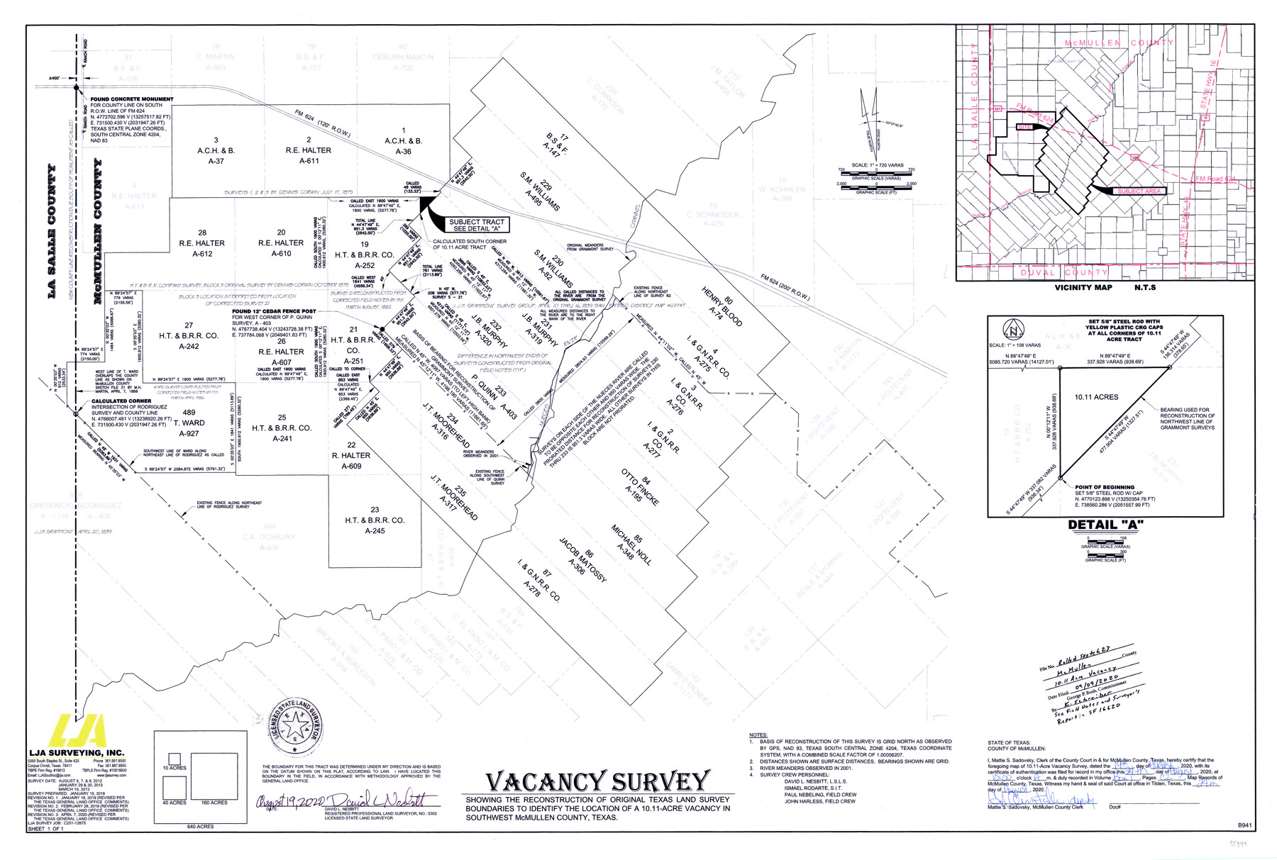
McMullen County Rolled Sketch 23
Vacancy survey showing the reconstruction of original Texas land survey boundaries to identify the location of a 10.11 acre vacancy in southwest McMullen County, Texas
-
Map/Doc
95949
-
Collection
General Map Collection
-
Object Dates
2020/8/19 (Creation Date)
2020/9/9 (File Date)
2019/3/19 (Survey Date)
-
People and Organizations
David L. Nesbitt (Surveyor/Engineer)
Ismael Rodarte (Chainman/Field Personnel)
Paul Nebeling (Chainman/Field Personnel)
John Harless (Chainman/Field Personnel)
-
Counties
McMullen
-
Subjects
Surveying Rolled Sketch
-
Height x Width
24.5 x 36.3 inches
62.2 x 92.2 cm
-
Medium
mylar, print
-
Scale
1" = 720 varas
-
Comments
See field notes and surveyor's report in SF-16620.
Part of: General Map Collection
Copy of Surveyor's Field Book, Morris Browning - In Blocks 7, 5 & 4, I&GNRRCo., Hutchinson and Carson Counties, Texas

Print $2.00
- Digital $50.00
Copy of Surveyor's Field Book, Morris Browning - In Blocks 7, 5 & 4, I&GNRRCo., Hutchinson and Carson Counties, Texas
1888
Size 6.9 x 8.8 inches
Map/Doc 62260
Map of the Roman Empire to illustrate Ancient History, engraved for Olney's school atlas

Print $20.00
- Digital $50.00
Map of the Roman Empire to illustrate Ancient History, engraved for Olney's school atlas
1845
Size 12.1 x 19.0 inches
Map/Doc 93550
Wood County Working Sketch 7

Print $20.00
- Digital $50.00
Wood County Working Sketch 7
1942
Size 41.0 x 37.7 inches
Map/Doc 62007
Right of Way and Track Map, Texas & New Orleans R.R. Co. operated by the T. & N. O. R.R. Co., Dallas-Sabine Branch

Print $40.00
- Digital $50.00
Right of Way and Track Map, Texas & New Orleans R.R. Co. operated by the T. & N. O. R.R. Co., Dallas-Sabine Branch
1918
Size 24.6 x 56.4 inches
Map/Doc 64631
Nueces County Rolled Sketch 63A

Print $20.00
- Digital $50.00
Nueces County Rolled Sketch 63A
1979
Size 25.0 x 36.7 inches
Map/Doc 6910
Flight Mission No. BRE-2P, Frame 44, Nueces County

Print $20.00
- Digital $50.00
Flight Mission No. BRE-2P, Frame 44, Nueces County
1956
Size 18.7 x 22.9 inches
Map/Doc 86746
Johnson County

Print $20.00
- Digital $50.00
Johnson County
1859
Size 22.0 x 29.6 inches
Map/Doc 3732
Galveston County Rolled Sketch 28

Print $347.00
- Digital $50.00
Galveston County Rolled Sketch 28
Size 22.6 x 18.1 inches
Map/Doc 6068
[Sketch for Mineral Application 33721 - 33725 Incl. - Padre and Mustang Island]
![2878, [Sketch for Mineral Application 33721 - 33725 Incl. - Padre and Mustang Island], General Map Collection](https://historictexasmaps.com/wmedia_w700/maps/2878.tif.jpg)
Print $20.00
- Digital $50.00
[Sketch for Mineral Application 33721 - 33725 Incl. - Padre and Mustang Island]
1942
Size 29.8 x 22.7 inches
Map/Doc 2878
Calhoun County NRC Article 33.136 Sketch 13

Print $24.00
Calhoun County NRC Article 33.136 Sketch 13
2023
Map/Doc 97272
Dallam County Working Sketch Graphic Index

Print $40.00
- Digital $50.00
Dallam County Working Sketch Graphic Index
1926
Size 41.3 x 50.9 inches
Map/Doc 76516
Matagorda County

Print $40.00
- Digital $50.00
Matagorda County
1920
Size 40.6 x 48.6 inches
Map/Doc 73232
You may also like
Edwards County Sketch File 19

Print $20.00
- Digital $50.00
Edwards County Sketch File 19
Size 17.1 x 23.7 inches
Map/Doc 11430
Energy Map of Texas

Print $20.00
- Digital $50.00
Energy Map of Texas
2020
Size 36.0 x 36.0 inches
Map/Doc 96436
Sulphur River and Cuthand Creek, Hardison Lake Sheet

Print $20.00
- Digital $50.00
Sulphur River and Cuthand Creek, Hardison Lake Sheet
1919
Size 13.4 x 18.0 inches
Map/Doc 78327
Travis County Rolled Sketch 54

Print $20.00
- Digital $50.00
Travis County Rolled Sketch 54
Size 25.2 x 36.7 inches
Map/Doc 8046
[Surveys made in Peters Colony by Thomas Leckie]
![1984, [Surveys made in Peters Colony by Thomas Leckie], General Map Collection](https://historictexasmaps.com/wmedia_w700/maps/1984.tif.jpg)
Print $20.00
- Digital $50.00
[Surveys made in Peters Colony by Thomas Leckie]
1859
Size 15.1 x 13.4 inches
Map/Doc 1984
Liberty County Rolled Sketch JLW

Print $40.00
- Digital $50.00
Liberty County Rolled Sketch JLW
1935
Size 28.0 x 85.5 inches
Map/Doc 9665
Special Map of the Great Southwest for Burke's Texas Almanac

Print $20.00
Special Map of the Great Southwest for Burke's Texas Almanac
1885
Size 42.1 x 28.5 inches
Map/Doc 76214
Coke County Sketch File 8

Print $20.00
- Digital $50.00
Coke County Sketch File 8
Size 20.2 x 27.8 inches
Map/Doc 11106
[Victoria District]
![1945, [Victoria District], General Map Collection](https://historictexasmaps.com/wmedia_w700/maps/1945.tif.jpg)
Print $20.00
- Digital $50.00
[Victoria District]
Size 34.8 x 25.6 inches
Map/Doc 1945
Young County Sketch File 14

Print $20.00
- Digital $50.00
Young County Sketch File 14
1895
Size 10.9 x 27.3 inches
Map/Doc 12712
Free & Williams Subdivision of the north half of Outlots 56 and 57

Print $20.00
- Digital $50.00
Free & Williams Subdivision of the north half of Outlots 56 and 57
Size 10.9 x 29.5 inches
Map/Doc 475
Flight Mission No. CLL-1N, Frame 191, Willacy County

Print $20.00
- Digital $50.00
Flight Mission No. CLL-1N, Frame 191, Willacy County
1954
Size 18.3 x 22.0 inches
Map/Doc 87061